
Petrographic and Structural Study of Stalactites and Stalagmites of Mfamosing Camp II Cave in Cross River State, South Eastern Nigeria
- Mbee, Sarah Barigbue
- Prof. N Egesi
- 541-553
- Jun 26, 2024
Petrographic and Structural Study of Stalactites and Stalagmites of Mfamosing Camp II Cave in Cross River State, South Eastern Nigeria
*Mbee, Sarah Barigbue, & Prof. N Egesi
Department of Geology, University of Port Harcourt, Choba, Rivers State, Nigeria
*Corresponding author
DOI: https://doi.org/10.51584/IJRIAS.2024.905048
Received: 20 April 2024; Revised: 22 May 2024; Accepted: 27 May 2024; Published: 26 June 2024
ABSTRACT
This study investigated the petrographic and structural features of Mfamosing camp II cave stalactites and stalagmites. The cave is in the karst region of Udukpani in Cross River State, Southeast Nigeria. The objective of the study was to gain insights into the mineral composition, texture and structure of the stalactites and stalagmites of the cave through petrographic analysis. The study employed a methodology that involved field study, collection of representative samples, preparation of thin sections, and examination under a petrographic microscope. Field observations revealed that the stalactite and stalagmites were leucocratic in color. The rocks exhibited similar texture which was fine grained. The cave contained large number of stalactites and stalagmites of varrying lengths (icicle and cone dome shapes) with stromalitic features on the wall. The petrographic analysis revealed the predominance of carbonates (calcite) as the primary mineral. The average estimated minerals composition present were 54.5% of Calcite, 5.3% of Quartz, and 2% of feldspar for stalactites. 51% of Calcite, 5% of Quartz, and 2.67% of feldspar for stalagmites. The results shows that the major mineral composition of the speleothems the cave are CaO.
INTRODUCTION
The background of this study is rooted in the geological formation of speleothems in the Mfamosing camp II cave. Mfamosing camp II cave is one of the most distinctive features of the Karst topography of Mfamosing limestone region. A cave is a naturally formed opening in the Earth’s surface that extends beyond the area illuminated by natural light and is large enough for humans to enter. Caves, discovered within diverse rock formations and shaped by distinct geological mechanisms, exhibit a wide range of dimensions, ranging from compact chambers to vast systems of interlinked tunnels that extend over several miles. Caves, when depicted on maps or in cross sections, may appear complex or disorganised, but they typically comprise three primary components: (1) passages, (2) chambers, and (3) one or more entrances. The positioning of a cave is predominantly influenced by geological or hydrological factors, which determine its form, magnitude, and measurements (Davies and Morgan, 2023).
Speleothems consist primarily of calcium carbonate and form in caves through the process of chemical precipitation from water drips or thin films. Stalactites and stalagmites are two prevalent types of speleothems found in caves. Stalactites hang down from the cave’s roof or wall, while stalagmites rise vertically from the cave floor.
Caves are highly significant, primarily because they contain mineral formations called speleothems. The presence of speleothems in karst caves has yielded valuable information about historical climate fluctuations on a worldwide level, spanning from orbital to seasonal time periods (Gabriella et al., 2018). The importance of these speleothems as indicators of previous climates is widely recognised. The Mfamosing camp II cave contains a significant number of speleothems that can offer valuable information about the current climate conditions in the area. Although caves are often linked with karst, it is crucial to acknowledge that within karst systems, caves attract substantial research and public attention. The location of a cave is typically determined by geological or hydrological factors, which dictate its shape, size, and dimensions. The importance of a cave is not solely determined by its size; even a cave of modest proportions can possess valuable resources or qualities. The mineral value and resources of caves have been largely underestimated.
Speleothems are frequently used terrestrial formations for reconstructing regional paleoclimatic conditions, primarily by analysing stable oxygen isotopes. However, the isotopic signals are very prone to undergoing post-depositional recrystallization. The uncertainty of the isotopic dataset’s reliability can only be resolved through a comprehensive petrographic analysis. Dipanwita et al (2022) propose that integrating isotopic investigations with comprehensive petrography can enhance the precision of paleoclimate assessments and mitigate the potential for misinterpretation caused by diagenetic alterations in carbonate. The objective of this study is to analyse the petrography and mineralogy of the limestone cave rock in Mfamosing camp II.
The Study Area
The study area is situated within the Odukpani Local Government Area of Cross River State, Nigeria. The study area is situated within the geographical coordinates of approximately 5° N and 6° N latitude and 8° E and 9° E longitude (as shown in figure 1). The study area has a humid tropical climate characterised by distinct wet and dry seasons. The rainy season spans from April to November, characterised by two distinct peaks in June to July and September to October. The arid season spans from December to April, reaching its pinnacle of drought and high temperatures in March. The harmattan weather prevails during the arid season, specifically from December to February. This phenomenon is distinguished by a parched and gritty breeze, accompanied by exceptionally frigid nighttime temperatures. The annual precipitation fluctuates between 2000mm and 4300mm, while the average temperature ranges from 22°C to 25°C (Nigerian Meteorological Agency NIMET, 2012). The region is defined by its elevated and uneven terrain, which is composed of fragmented and irregular landforms consisting of eroded steep ridges and deep valleys. Vegetation refers to the plant coverings found on the Earth’s surface, which are determined by the distribution of rainfall. Specific areas within the region are characterised by expansive rainforests and mangrove forests, while other regions showcase thriving freshwater vegetation, such as densely populated rubber tree cultivation. The climate conditions generally facilitate the flourishing of dense rainforest vegetation.
Geology of the study area
The location of the Mfamosing camp II cave is on the Calabar Flank. The Calabar Flank, is located inside the West African Rift System, has great geological importance. It is located in the southeastern region of Nigeria and the southern section of Cameroon (Figure 2). This region’s geological composition is unique due to the interplay of sedimentary sequences, tectonic features, and volcanic influences, setting it apart from other locations worldwide. Ibe et al. (2005) have shown that the Calabar Flank Basin is of Mesozoic age. Specifically, the basin’s age ranges from around 252 million years ago to 66 million years ago. The Calabar Flank is underlain by a significant number of sedimentary strata. The formations consist of shales, sandstones, limestone, and marl. The formation of these sedimentary strata may be attributed to the gradual buildup and settling of silt over millions of years, a process often associated with the Gulf of Guinea (Akaegbobi et al., 2004). The Calabar Flank is characterised by an abundant presence of limestone, a remarkable geological formation. An instance of this is the Mfamosing Limestone Formation, a geological formation located on the Calabar Flank. The importance of these findings stems from the use of limestone in cement production, as well as its role in indicating the sea’s encroachment and the diagenetic history of the region. According to Oden, 1992.
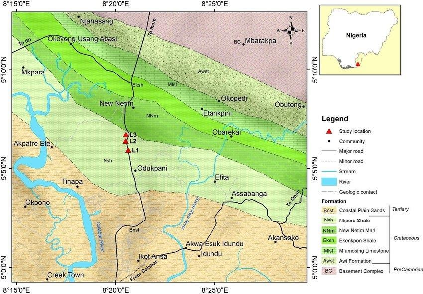
Figure 1: Geological Map of Calabar Flank showing the study location (adapted from Google Earth, 2019).
Mfamosing Limestone Formation
The Mfamosing limestone originated in the Calabar Flank as a result of deposition. The Calabar Flank is geologically linked to the subsided portion of the Southern Nigerian Continental margin. The region is mainly defined by a prevailing network of step faults that trend in a northwest to southeast direction. The presence of this fault system has resulted in the formation of a horst, referred to as Itu high, and a trough, known as Ikang low, in the area. The horst functioned as the site where carbonate sediments accumulated, while clastic materials were deposited in the graben. The Ikang trough underwent uninterrupted clastic sedimentation throughout its deposition period, while the Itu high remained a stable carbonate platform where around 450m of the Mfamosing Limestone was deposited (Reijer and Petters, 1987). The Mfamosing Limestone is overlaid by a significant sequence of shale units, varying in colour from black to grey, which is referred to as the Ekenkpon Formation. The Ekenkpon shales are overlain by a significant deposit of marl referred to as the New Netim Marl (Perch – Neilson and Petters, 1981). The New Netim Marl is overlain by a stratum of carbonaceous dark grey shale known as the Nkporo Formation (Reyment, 1955). Figure 3 illustrates the configuration of rock strata in the Calabar Flank, where the Mfamosing limestone is found.
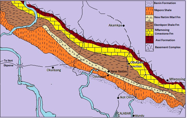
Figure 2: Geology outline map and stratigraphy unit of the Calabar flank (After Abdulrahman 2016)
LITERATURE REVIEW
The southeastern Nigeria is dominated by Cretaceous and Tertiary sediments but there are isolated basement units exposed in Obudu plateau area and Oban Massif. The Oban Massif is a continuation of the Precambrian shield of the Cameroon to the east. The southeastern Nigeria has Obudu plateau and Oban Massif as the only Precambrian basement outcrops in southeastern Nigeria. They are giant spurs forming the western prolongation of the Cameroon Mountain into the Cross Rivers plain of southeastern Nigeria (Ekwueme, 1991). The basement complex has undergone series of tectonism, magmatism and region metamorphism which has led to the development of fractures; fold, faults among others creating favourable site for mineralization, (Ekwueme 2003, 2013).
According to the research conducted by Udofia and Udo (2021), the karst features seen at the study sites in the Mfamosing Limestone Calabar Flank in South Eastern Nigeria are indicative of tropical climates. Among the features that were shown were towers, pinnacles, karrens, subterranean caverns, speleotherms, phreatic tubes, dolines, uvalas, and plains devastated by corrosion. In their statement, they emphasised that the exceptional karst features would definitely provide students of carbonate geology with an exceptional field experience. In addition, it was pointed out that the humid tropical Mfamosing karst landforms had an interesting topology that might attract tourists. For the sake of preservation, it is suggested that the Federal Government of Nigeria and the United Nations formally designate these areas as world heritage sites. The security of future geotourism locations would be guaranteed by this measure. According to research on the Mfamosing Limestone conducted by Essien and Edet (2001), calcite is the main mineral structure found in the limestone, with quartz being a minor mineral inclusion.
To put it simply, caves are formed when limestone dissolves. As it moves through the soil, carbon dioxide undergoes a chemical reaction that turns it into a weak acid, a process known as precipitation. The gradual dissolving process wears away the limestone from the bedding planes, joints, and cracks, resulting in the formation of caves. Caves are formed and some of these locations are enlarged as a result of this process (British Geological Survey, NERC 2023). Cave formations known as speleothems may be the outcome of a number of different mineral precipitation processes. The majority of the time, they are composed of minerals such as calcite or aragonite that are washed down from above by water that runs or seeps into the cave. It is possible to find a wide variety of speleothems in limestone caves and other cave types. There is a vast variety of speleothem forms, sizes, and hues (Geology research 2023).
Flowstones, stalactites, stalagmites, columns, helictites, and cave pearls are all examples of speleothems, a collective noun for certain cave structures. Geological formations may be described as speleothems. Stalactites are long, elongated mineral structures that, when hanging from a cave’s ceiling, seem like icicles. When calcium carbonate (CaCO3)-containing water falls from the sky and evaporates, it leaves behind calcium carbonate deposits that eventually turn into stalagmites. A stalactite forms when calcium carbonate builds up over time and does not dissolve easily. The floor of a cave often displays vertical formations called stalactites. Stalagmites are created when calcium carbonate-containing water falls or washes over the cave floor, then evaporates, leaving behind a layer of calcium carbonate on the floor. According to the National Geographic Society (2023), a stalagmite forms as calcium carbonate builds up and hardens over time.
Stalactites and stalagmites form a continuous column of calcium carbonate as they develop together and eventually meet. As a consequence of this procedure, columns are formed. Calcium carbonate is deposited when water rushes over a cave’s surface, creating flowstones. Depending on the mineral deposition and flow pattern inside the material, they may assume various shapes and sizes, such as sheets, ribbons, and draperies. Among the many forms that speleothems may take, helical, curved, or twisted helictites stand out. These formations are thought to have been created by capillary action, which is the process of water being drawn up through small cracks or holes in the cave wall. The formations are complex and often delicate because the water causes the precipitation of calcium carbonate as it flows. Small, spherical speleothems called “cave pearls” are created when calcium carbonate-laden water droplets fall or roll over a cave floor, forming layers around a nucleus (National Geographic Society 2023). One kind of speleothem is cave pearls.
The time it takes for a speleothem to grow to a size where it can be identified may range from hundreds of thousands to millions of years. Slowly but surely, speleothems are built up. Cave ecosystems cannot be fully understood without them, since they hold the key to revealing past climate, hydrology, and geological events (Geology Science, 2018). In order to comprehend cave environments, cave civilizations are extremely significant.
Importance of speleothems as pleoclimate indicators
Scientists strive to obtain further climate data from speleothems. The rocks possess the capacity to function as a climate record through the utilisation of oxygen isotope ratios. Water encompasses two prominent forms of oxygen that are of great importance in paleoclimate research: heavy and light. The distribution of these different oxygen types in water varies depending on air temperature, the total amount of ice on Earth, and the level of local precipitation—all essential elements of the climate puzzle. The ratio exhibits partial conservation in the cave rocks, allowing scientists to employ this clue to obtain insights into the climate conditions during the rock’s formation. Lately, scientists have started using the oxygen isotope ratio to track changes in rainfall levels. More precisely, they note that there is a correlation between heavy rainfall and an increased abundance of light oxygen. Moreover, this approach enables them to ascertain the origin of the rainfall, whether it came from the ocean or inland sources.
MATERIALS AND METHOD MATERIALS
The following materials and equipment were used during the course of this research.
- Topographic map: The base map serves as a guide as well as platform on which the geology is superpo
- Geologic hammer: This is essential equipment for sample collection especially, in the basement terrains.
- Geology field notebook: This was used to take on the spot records of measurements, observations, sketches among others.
- Sample bags: Sample bags were used to carry rock samples from one location to another in the field and back to the ba
- Masking tape: This was used to label our sample in terms of the field name as well as the location. It helps to eliminate mix up of rock sample
- Marker pen and pencil: They were used to label samples and to fill the field notebook respectively.
- Global positioning system: This was used to locate the coordinates (Longitudes and Latitudes)
- Hand lens: The hand lens aided in seeing microstructures and minerals in a higher resolution.
- Camera: This was used to import the field view to the office or laboratory for further observation and studie
Methods
This research commenced with a desk study, and geologic field mapping. The study involved collection of samples in the study area. The standard method of data acquisition, analysis and interpretation was adopted in this study.
Field Method
In the field, data acquisition of outcrops, exposures, stream channels, and quarries were visited. Detailed field observation and recording were made in real time in the study area.
The likely rock type symbols as well as structures were plotted on the base map in the field. Rock samples were collected in proportion to the cave dimension (about 3mx4m which is about a room dimension). Eight rock samples were collected in total. Four for stalactites and four for stalagmites.
Petrographic study
The rock samples collected were taken to the laboratory for thin section analysis (Figure 3).
Procedure for preparation Petrographic Analysis
The impregnation method was used in which the samples were cut, grind and poured into a cut glass tube with paper under it and consolidated using epoxy and heat.
The samples were polished (the paper was polished off as well) using polishing glass with carborandum sprinkled on it. The purpose was to smoothen one surface. It was done in both clockwise and anticlockwise direction.
The polished samples were then washed with clean water and then dried with hot plate with polished surface facing upward.
Glass slide surface was polished with abrasive F600 and then washed. Glass sides was then washed with a clean water and then dried with hot plate with polished surface facing upward.
Araldite A and B were mixed and a known quantity was picked with the aid of a spatula and smired on the polished surface of the glass slide.
Polished rock samples were placed on the glass slide with forceps.
The mounted samples is then placed on the mounting jag already on the hot plate.
The mounted sample is left on the hot plate for about 20-2mins and then removed.
The samples were taking to the petrographic microscope for viewing and study.
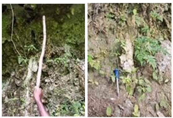
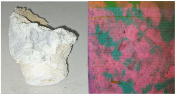
(a) An Outcrop of Stalactites (b) An Outcrop of Stalagmites
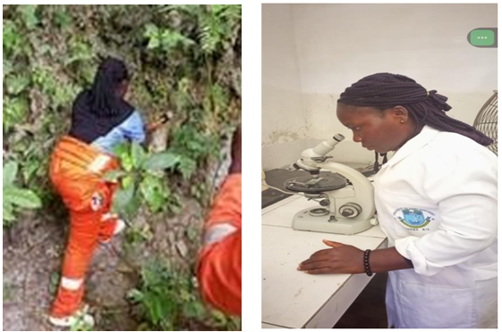
(c) Collection of Samples for Study Area (d) Petrographic Study of the Samples
Figure 3: Shows sample collection in the field, laboratory analysis and petrographic studies during the course of the study.
RESULTS AND DISCUSSION
Thin section and petrographic result
The results of the rock sample analysis are shown in figure 4 to 6 and the visual estimate of the mineralogical content are show on Tables 1 and Table 2. Eight slides were gotten from the thin sectioning of the speleothem samples from the cave. Four samples for stalactites and four for stalagmites. The slides obtained from the thin sectioning of the mineral samples were studied using petrographic microscope under plane polarized light (PPL) and cross polarized light (XPL). A visual estimate of the various concentrations (in percentage) of the identified minerals was obtained. The hand specimen from the study area revealed that the speleothems in the the cave were leucocratic in nature (light coloured rock).
Table 1: Visual estimate of sample Stalactites
| Sample No. | Calcite (%) | Quartz (%) | Feldspar (%) |
| 1 | 56 | 3 | 3 |
| 2 | 53 | 7 | 1 |
| 3 | 55 | 6 | 2 |
| 4 | 54 | 5 | 2 |
| Average | 54.5 | 5.3 | 2 |
Sample 1
Sample 2

Sample 3
Sample 4
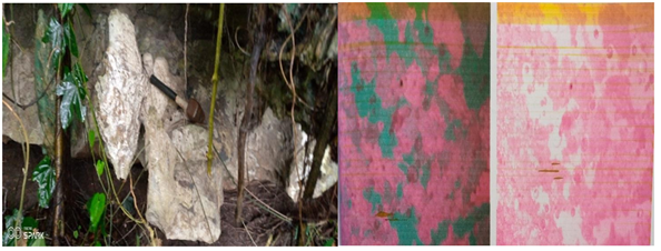
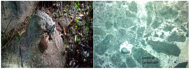
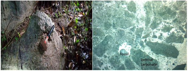
Figure 4: shows Pictures of stalactites (Field photographs versus microphotograph)
Table 2: Visual estimate of mineral composition of sampled Stalagmites
| Sample No. | Calcite (%) | Quartz (%) | Feldspar (%) |
| 5 | 46 | 5 | 3 |
| 6 | 48 | 4 | 3 |
| 7 | 59 | 6 | 2 |
| 8 | 51 | 5 | 2.67 |
| Average | 51 | 5 | 2.67 |
Sample 5
Sample 6
Sample 7
Sample 8
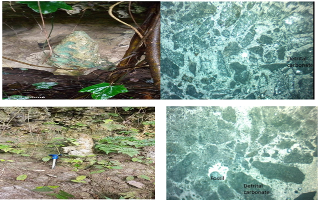
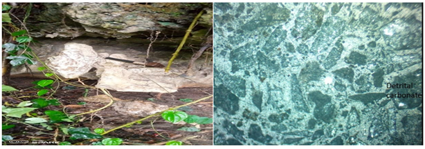
Figure 5: Showing pictures of stalagmites (field photographs versus microphotographs)
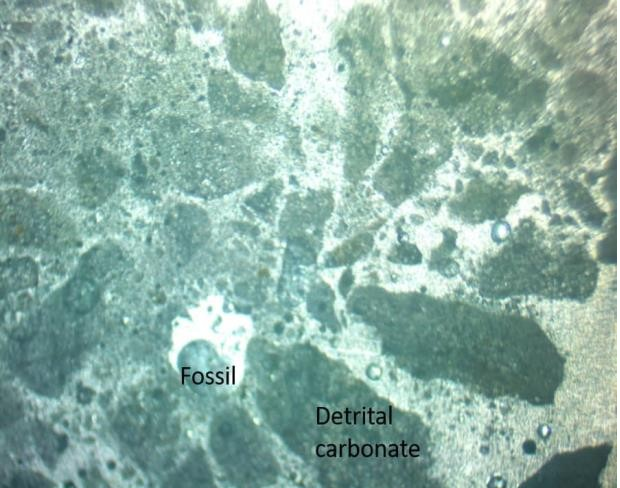
Figure 6: Photomicrograph of Mfamosing speleothems showing the presence of microfossils
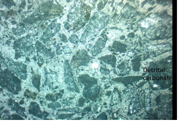
Figure 7: Photomicrograph of Mfamosing speleothems showing the presence of carbonate mineral (CaCO3)
DISCUSSION
When examined using a petrographic microscope, the samples exhibited a similar texture characterized by the existence of detrital rock fragments enclosed in a matrix of very fine- grained minerals. The primary constituents of these are carbonate (calcite), quartz, and plagioclase feldspar. Furthermore, there exist minute quantities of chlorite flakes and microfossils.
Carbonate minerals can be categorised into three types: detrital carbonates, which are the most prevalent and mainly consist of calcite; chemical carbonates; and carbonates originating from microfossil remains.
The samples contain a large amount of detrital carbonates. The grains exhibit a sub- rounded morphology and exhibit the characteristic interface colours commonly observed in carbonate minerals. Some grains display recurrent or lamellar twinning, which resembles the twinning observed in plagioclase feldspar. Nevertheless, plagioclase feldspar exhibits minimal interference colours. Calcite (CaCO3) is the most likely composition of carbonate grains. Dolomite, which closely resembles calcite, cannot originate from detrital sources when observed under a microscope.
Quartz is a common detrital mineral present in all samples. The mineral is present in grains that exhibit an irregular to sub-rounded morphology. These grains are characterised by their lack of cleavage, minimal interference colours, and either a wavy or complete extinction. Some grains develop reaction rims due to the replacement of silica with carbonate.
Plagioclase feldspar fragments are considerably less abundant in comparison to carbonates. Their morphology is characterised by subhedral to angular shape, indicating their origin from detritus. Their appearance is characterised by a distinct and easily identifiable pattern of repeated or lamellar twinning.
Petrographic examination also identified diverse shapes like rounded, sub rounded, irregular, subhedral, angular.
Microfossils: Due to the coiled multi chambered shells, this fossil is an Ammonoid, a Devonian – Cretaceous cephalopod mollusks of marine origin. Due to the presence of these fossils (Ammonoids), the depositional environment of the cave can be said to be marine because these devonian to cretaceous cephalopod thrived in marine environment. The photomicrographs of the samples are shown in figure 8 & 9.
Structural and morphological features of Mfamosing camp II cave
Stalactites and stalagmites are mineral formations commonly found in caves in karst regions. They were found in large quantities in the study cave.
Stalactites: the Stalactites were icicle-shaped formations that hung from the ceilings of the cave. The stalactites were soft, elongated, and crystalline and vary in length 3cm-13cm.
Stalagmites: the Stalagmites grew upward from the floor of the cave and were formed by the same process as stalactites. Mineral-rich water drips onto the cave floor, leaving minerals behind as it evaporates. The stalacmites were solid, crystalline and were longer and bigger than the stalactites (20-65cm).
They occurred as a result of prolonged geological processes involving sedimentation, dissolution, and precipitation of calcium carbonate.
Stromalitic structures were also seen on the cave walls and something like erosion or dissolution were also seen.
The cave is a limestone karst cave. The cave has a width ranging from 10 to 40 metres and includes passages, chambers, and entrances that are decorated with speleothems. The cave’s interior is completely lacking in light, which makes it necessary to use a lamp in order to enter. The cave entrance is adequately roomy for human entry and corresponds to the cave description given by Davies and Morgan (2023). The cave is currently flooded due to the nearby river overflowing, and there is a wetland area at the bottom of the cave.
CONCLUSION
Study of the Petrographic and Structural Features of Mfamosing camp II cave in Cross River State, Southeast Nigeria has unraveled a great detail about the geological, structural, and petrographic characteristics of the cave. Petrographic analysis revealed a predominant mineral composition of calcite (CaCO3) alongside quartz, and plagioclase feldspar. The depositional environment of the cave is marine because of the presence of micro fossils (Ammonoids). Structural features like karst topography, stalactites and stalagmites with varying lengths and shapes were discovered during the field work. They occurred as a result of prolonged geological processes involving sedimentation, dissolution, and precipitation of calcium carbonate. The average estimated minerals composition present is 54.64% of Calcite, 5.33% of Quartz, and 2% of feldspar for stalactites. 51% of Calcite, 5% of Quartz, and 2.67% of feldspar for stalagmites. The results show that the major mineral composition of the rocks in the cave is CaO.
REFERENCES
- Aber, J. S. (2003). Structural geology of rocks and regions (3rd ed.). Wiley.
- Adeleye, D. R., Obasi, R. A., & Adelusi, O. (2018). Geological and structural interpretation of the Lower Benue Trough and the Calabar Flank, southeastern Nigeria, from aeromagnetic data. Journal of African Earth Sciences, 147, 57-71.
- Akaegbobi, I. M., Esu, E. O., Essien, N., & Oden, I. (2004). Geology of the Cross River State, Nigeria. Journal of Mining and Geology, 40(1), 67-78.
- British Geological Survey, NERC (2023). https://www2.bgs.ac.uk/mendips/caveskarst/ caveform. htm#:~:text=Caves % 20are % 20 formed % 20 by % 20 the, enlarged % 20 enoug h % 20 to % 20 form % 20 caves.
- Climate Change Science (2023) Paleoclimate studie https://iu.pressbooks.pub/zkilibar/
- Cross River State Ministry of Environment and Mineral Resou (2019). Geological survey report: Mfamosing limestone deposit.
- Davies, W. E. and Morgan M. (2023) U.S. Department of the Interior / U.S. Geological Survey Geology of Caves. https://pubs.usgs.gov/gip/7000072/report.pdf retrieved 12th september 2023
- Dipanwita Sengupta, Som Dutt, and Subhojit Saha (2022) Coherent nature of speleo thems petrographic and isotopic proxies for climate change: A case study from northwestern Himalaya. Geological Journal Volume 57, Issue 7 p. 2904-2913
- Ekwueme, N., (1990). Petrology of southern Obudu Plateau, Bemenda Massif, southeastern Nigeria. In: Rocci. G and Deschamps M. (ed). Recent data in African Earth science. CIFEG Occassional publications, 22, 155-158.
- Ekwueme, B. N., Gabriel, B. A., and Bassey, E. E., (2013). The chemical composition and industrial quality of barite mineralization in Calabar Flank, Oban Massif, Mamfe Embayment and Obudu Plateau, Southeastern Nigeria. Global Journal ofGeological Science, (13),1, 53-
- Essien N. U. and Edet E (2008). Factor Analysis of the distribution of trace and minor elemental oxides and clay minerals in the Mfamosing Limestone, Southeastern Nigeria. International Journal of Natural and Applied Sciences. Vol. 3, pg: 35 and 36.
- Fisher, R. V., & Schmincke, U. (1984). Pyroclastic Rocks. Springer-Verlag.
- Gabriella Koltai, Hai Cheng, and Christoph Spötl (2018). Palaeoclimate significance of speleothems in crystalline rocks: a test case from the Late Glacial and early Holocene
- Geology science (2023) What are speleothems and how do they form? https://geologyscience.com/forums/topic/what-are-speleothems-and-how-do-they- fonn/?amp
- Holli Riebeek (2005). Paleoclimatology. NASA Earth Observation Ibe, K., Oden, M. I., Oden, M. A., & Ibe, A. E. (2005). The Calabar Flank, SE Nigeria: A structure developed on a continental volcanic platform. Journal of African Earth Sciences, 42(5), 348-358.
- International journal of Geology, agriculture and environmental science 2013. Nigerian Meteorological Agency NIMET, 2012.
- MacGregor, C.L.V., Hellstrom, J.C., Woodhead, J.D., Drysdale, R.N., Eberhard, R.S., 2022. Low impact of sampling speleothems − reconciling scientific study with cave conservation. International Journal of Speleology, 51(1), 1-11. https://doi.org/10.5038/1827-806X.51.1.2406
- National Geographic Society (2023) Sedimentary Rock https://education.nationalgeographic.org/resource/sedimentary-rock/
- Nyong, E.E (1995). Geological Excursion Guide book to Calabar Flank and Oban Massif. In the 31st Annual conference of the Nigerian Mining Geosciences Society, Calabar, March 12-
- Obaje NG (2009) Geology and Mineral Resources of Nigeria. Springer, Dordrecht Heidelberg London, p 110.
- Oden, I. (1992). Geology of Nigeria’s sedimentary basins. Nigerian Mining and Geosciences Society.
- Okeke, F. N., & Onwuemesi, G. (2017). Petrographic and geochemical study of limestone samples from Mfamosing, Nigeria. Journal of Geology and Mining Research, 9(3), 29-38.
- Perch – Nielson, K. and W. Peters, (1981). Cretaceous and Eocence Microfossil ages, from the southern Benue Trough, Nigeria. Paleontographica (125) 2 102-120. Petters, S. W. (1982). Central West African Cretaceous-Tertiary benthic foraminifera and stratigraphy. Paleontographica (179)1-104.
- Rahaman, A. (1988). Recent advances in the study of the basement complex of Nigeria. Precambrian Research, 38(1-4), 1-13.
- Reijers, T.J.A and S.W. Petters, (1987). Depositional enviroment and diagenesis of Albian carbonates in Calabar Flank, S. E. Nigeria: Journal of Petroluem Geology. (10), 283-294.
- Reyment, R, A., (1965). Aspects of the Geology of Nigeria, Ibadan University. Press, Ibadan, 455.
- Stokes, T.R., P. Griffiths, and Ramsey. 2007. Preliminary microclimate study of forested karst sinkholes, Nimpkish River Area, Northern Vancouver Island, British Columbia, Canada. Poster presented at 17th Australasian Conference on Cave and Karst Management, Buchan, Victoria
- Udofia, P. , Udo, I. G. (2021) Karst Morphology and Geotourism Potential of Mfamosing Limestone Calabar Flank, South Eastern Nigeria. The Journal of Applied Geology and Geophysics. ISSN: 2321–0990, p-ISSN: 2321–0982.Volume 9, Issue 3 Ser. II. PP 15-30