
Assessment of Reservoir Quality of the Cretaceous Yolde Sandstone: A Case Study of Doma Stream, Gongola Basin, Northern Benue Trough, Northeast Nigeria.
- Bello, M. U.
- Maigari, A. S.
- Emmanuel, E.
- Michael, O. I
- 148-158
- Nov 30, 2023
- Poultry
Assessment of Reservoir Quality of the Cretaceous Yolde Sandstone: A Case Study of Doma Stream, Gongola Basin, Northern Benue Trough, Northeast Nigeria.
*Bello, M. U., Maigari, A. S., Emmanuel, E., and Michael, O. I.
Department of Applied Geology, Faculty of Science, Abubakar Tafawa Balewa University, Bauchi
*Corresponding Author
DOI: https://doi.org/10.51244/IJRSI.2023.1011011
Received: 05 November 2023; Revised: 19 November 2023; Accepted: 21 November 2023; Published: 30 November 2023
ABSTRACT
Sedimentology, petrography and petrophysical studies were applied to the Cretaceous Yolde Formation sediments along the Doma stream, to evaluate its reservoir quality. The Yolde Formation along the Doma Stream is composed of lithologies that are laterally extensive and have reached a thickness of about 80m. They are lithologically made of sandstones with dark grey mudstones, laminated shales and grey to pale yellow limestones. The Sandstones are structurally characterized by planar, tabular and trough cross-beds, convolute beds, and hummocky cross-stratifications with reactivation surfaces. Some of the sediments are bioturbated. The petrophysical evaluation indicated porosity values ranging from 6% to 26%, and permeability values between 12.7mD and 108mD. These values are comparable to the reservoir rocks of proven petroleum basins of the North Sea and Niger Delta. Therefore, the Yolde Sandstones of the study area can have great potential to serve as good reservoir rock in the Gongola Basin.
Keywords: Reservoir rock, porosity, permeability, Univariate, bivariate plots, Petrography, Yolde Sandstone, Gongola Basin.
INTRODUCTION
The Gongola Sub-basin is a petroleum frontier basin in Nigeria and part of a mega rift system termed the West and Central African Rift System (WCARS) within which several petroleum exploration successes were recorded in the neighboring countries of the Chad (Doba, Doseo, and Bongor fields), the Niger (Termit-Agadem Basin), Sudan (Muglad Basin) and more recently the Kolmani River-II discovery from the Sub Gongola Basin. Major reservoirs of hydrocarbon accumulations discovered in the WCARS are sandstones of the late Albian to Cenomanian age e.g., Bentiu Formation in the Muglad Basin and Sedigi Formation in the Termit-Agadem Basin (Lirong et al., 2013; Wan et al., 2014). These formations are lateral equivalents to the Yolde Formation of the Gongola Sub-basin of the Northern Benue Trough of Nigeria (Abubakar, 2014).
The Nigerian government’s attempt to expand its petroleum reserves led to oil exploration in northern Nigeria. The Nigerian National Petroleum Corporation (NNPC) drilled around 23 exploratory wells in the Nigerian sector of the Chad Basin but only encountered gas shows. This task was carried out by NNPC’s Frontier Exploration Services arm (FES), which was then under National Petroleum Investment Management Services (NAPIMS), as explained by Obaje (2019). In 1999, Shell Nigeria Exploration and Production Company (SNEPCO) drilled the first well in the Benue Trough, Kolmani River-I, to a depth of approximately 3 km and encountered only 33 billion standard cubic feet of gas with a small amount of oil. Two other wells, Kuzari-I and Nasara-I, were also reported dry. More recently, on February 2, 2019, President Muhammadu Buhari flagged off the drilling of Kolmani River II, a deeper well compared to Kolmani River I, near Barambu village in Alkaleri Local Government Area of Bauchi State. It was drilled to a total depth of about 13,701 feet (4,110m). The uncertainty of oil accumulation in northern Nigeria was put to rest on 11th October 2019, when the Nigerian National Petroleum Corporation verified the discovery of hydrocarbon (oil and gas) deposits in the Gongola basin which has estimated reserves of 1 billion barrels of crude oil and 500 billion cubic feet of gas deposit. According to the geology of these findings, Yolde Sandstone was believed to be a potential reservoir rock. However, little is known about the depositional conditions and reservoir capability of this significant reservoir unit (the Yolde Formation).
Reservoir rocks are primarily sedimentary rocks that result from the recycling of rock debris due to the weathering of pre-existing rocks, such as sandstone, limestone, dolomite, and shale. The reservoir rocks’ interconnected pore spaces enable petroleum to migrate and accumulate in a trap. This interconnectivity is described as permeability, which measures the hydrocarbon flow’s ease in the reservoir. A good reservoir system comprises the reservoir, trap, and impervious stratum, usually called caprock or seal, such as shale, overlying the reservoir. The ability of the reservoir rock to host and produce hydrocarbons largely depends on the degree of reservoir connectivity and the porosity/permeability characteristics of the reservoir unit during sediment deposition and subsequent burial. This research evaluates the Yolde sandstone facies’ reservoir capability extent and their impact on reservoir quality on the exposed part of the Yolde formation along the Doma Stream. Figure 1 is the map of the study area.
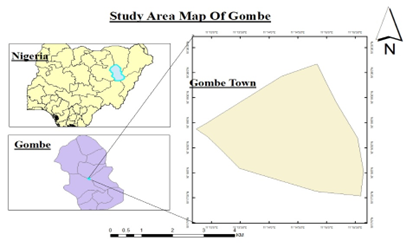
Figure 1: Map of the study area.
GEOLOGIC SETTING
The Benue Trough of Nigeria is part of the West and Central African Rift System (WCARS); a mega-tectonic structure formed by the tension generated due to the separation of the African and South American plates during the Early Cretaceous (Sarki et al., 2014). It is over 1000 km in length and exceeds 150 km in width. Its southern outcrop limit is the northern boundary of the Niger Delta Basin, while the northern outcrop limit is the southern boundary of the Chad Basin separated from the Benue Trough by an anticlinal structure termed the “Dumbulwa-Bage High”. The trough is filled with up to 6000 m of Cretaceous e Paleogene sediments (Abubakar, 2014; Sarki et al., 2014). The Benue Trough bifurcates into the Gongola arm and Yola arm and is arbitrarily subdivided into Southern, Central, and Northern sectors as shown in Figure 2.
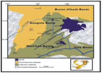
Figure 2: Geological Map of Northern Benue Trough (Modified from Zaborski et al 1997)
Most researchers such as Carter et al. (1963), Offodile (1976), Benkhelil (1989), Obaje et al. (2004), Abubakar (2014), Tukur et al. (2015) among many others have described the stratigraphy of the Northern Benue Trough, as seen in Figure 3, that comprises the continental lower cretaceous Bima formation, the Cenomanian transitional marine Yolde formation and the marine late Cenomaniane Santonian Dukul, Jessu, Sekuliye formations, Numanha Shales and Lamja sandstones. The Cenomanian transitional Yolde formation, the subject of this study, was earlier recognized by Carter et al. (1963) as the transitional marine beds conformably on the Bima formation (Figure 3), although the boundary between the two formations has been difficult to ascertain in both Gongola and Yola Sub-basins.
The lower part of the Yolde formation consists of alternating sandstones and dark-grey mudstones, while the upper part consists of bedded sandstones with argillaceous intercalations. Bioturbations and trace fossils are common towards the top while groove marks are on some beds. It was earlier interpreted as fluvial at its base and shallow marine at its upper part (Zarboski et al.,1997). Volcanic plugs of Tertiary age were reported in some of the Cretaceous formations in the Northern Benue Trough (Carter et al., 1963; Sarki Yandoka et al., 2014).
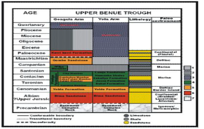
Figure 3: Diagram showing the stratigraphy of the Northern Benue Trough (Obaje et al, 1999)
METHODOLOGY
Fieldwork and laboratory analyses were used in this work. The fieldwork was conducted to produce a stratigraphic log of sedimentary succession, collect sandstone samples for laboratory analysis, analyze paleontological features and identify facies of the Cretaceous Yolde Formation. About 80 meters of the stratigraphic section were produced based on observations of various features, including color, sedimentary structures, texture, fossils, bioturbations, bed thickness, and geometry. From the base, it consists of dark grey bioturbated mudstone. The bed passes into laminated fine to medium-grained sandstones, Oil-stained medium-grained sandstones, planar, and tabular cross-bedded medium-grained sandstone with pebble lag deposits, Heterolitihic beds of sandstones and mudstones, Heterolithicc beds of sandstones and shales, bioturbated limestone to trough cross-bedded coarse-grained sandstone as shown in Figure 4.
A total of 16 sandstone samples were collected for granulometric analysis. Each sample, weighing 200 g, was subjected to a mechanical sieve shaker for 10 minutes, using standard sieves, as described by Krumbein and Pettijohn (1938). The graphical parameters, including graphic mean, standard deviation, skewness and kurtosis, were calculated using the formula of Folk and Ward (1957).
Petrographic analysis was conducted on 7 samples using a petrographic microscope to identify the framework minerals such as quartz, feldspar, and other rock fragments. The number of each mineral was counted and percentages were calculated. The obtained percentages were then plotted on Folk’s sandstone classification to determine the type of sandstone in the samples. A falling head permeameter test was conducted on 7 cores to determine the porosity and permeability of the Yolde Sandstone.
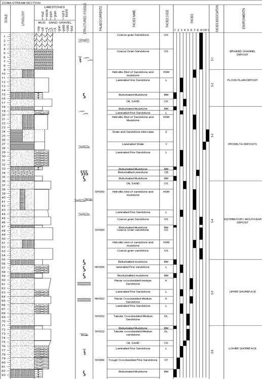
Figure 4: Stratigraphic section of Yolde formation along Doma stream
RESULTS AND DISCUSSION
The results obtained were presented and discussed as follows:
Univariate grain size parameters
The graphic mean size for the samples DM1 to DM16 ranges from 1.64ø to 2.65ø, which indicates that the samples are made up of medium to fine-grained sands. The fluctuation of the values may suggest a change in the strength of the depositional medium.
Table 1: Summary of Univariate grain size parameters
| Sample No | Mean (Mz) | Standard Deviation (δI) | Kurtosis (Kg) | Skewness (Ski) |
| DM1 | 1.67
Medium-grained |
1.25
Poorly sorted |
0.98
Mesokurtic |
0.29
Fine skewed |
| DM2 | 1.67
Medium-grained |
1.27
Poorly sorted |
0.95
Mesokurtic |
0.79
Strongly fine skewed |
| DM3 | 1.64
Medium-grained |
0.59
Moderately well sorted |
0.97
Mesokurtic |
0.93
Strongly fine skewed |
| DM4 | 2.16
Fine-grained |
0.75
Moderately sorted |
1.23
Leptokurtic |
0.74
Strongly fine skewed |
| DM7 | 2.20
Fine-grained |
0.80
Moderately sorted |
1.35
Leptokurtic |
0.91
Strongly fine skewed |
| DM8 | 2.65
Fine-grained |
0.94
Moderately sorted |
1.53
Very leptokurtic |
0.83
Strongly fine skewed |
| DM9 | 2.44
Fine-grained |
0.84
Moderately sorted |
1.35
Leptokurtic |
1.33
Strongly fine skewed |
| DM10 | 2.11
Fine-grained |
0.77
Moderately sorted |
1.27
Leptokurtic |
0.76
Strongly fine skewed |
| DM11 | 2.10
Fine-grained |
0.73
Moderately sorted |
1.21
Leptokurtic |
0.70
Strongly fine skewed |
| DM12 | 2.32
Fine-grained |
0.80
Moderately sorted |
1.36
Leptokurtic |
0.68
Strongly fine skewed |
| DM13 | 2.37
Fine-grained |
0.83
Moderately sorted |
1.33
Leptokurtic |
0.67
Strongly fine skewed |
| DM14 | 1.7
Medium grained |
0.69
Moderately well sorted |
1.30
Leptokurtic |
1.07
Strongly fine skewed |
| DM15 | 2.63
Fine-grained |
0.93
Moderately sorted |
1.53
Very leptokurtic |
0.93
Strongly fine skewed |
| DM16 | 2.19
Fine-grained |
0.84
Moderately sorted |
1.47
Leptokurtic |
1.00
Strongly fine skewed |
The standard deviation values indicate that the samples ranged from moderately well sorted (0.59ø) to poorly sorted (1.27ø), with an average of 0.86ø, suggesting that the entire formation is moderately sorted. The samples analyzed have skewness values ranging from 0.29ø to 1.33ø, indicating that they are positively fine skewed to strongly fine positively skewed, with strongly positively skewed values predominating with an average of 0.83 ø. This could be because the depositing current removed much of the silts and clays. The kurtosis values (Table 1) for the samples range from 0.95ø to 1.53ø (Mesokurtic to very Leptokurtic), with an average of 1.00ø (Mesokurtic).
Petrographic analysis
Six sandstone samples, ranging from fine to coarse-grained, were thin-sectioned and studied petrographically. The sandstones mainly comprise quartz, feldspars, and rock fragments as framework elements, with mica and other matrix and cement. The framework compositions of these sandstones are varied and are presented in Table 2.
Table 2 Textural Maturity and Petrographic Components
| S/N | Sample ID | Sorting | Roundness | Sphericity | Grain Fabric | Framework Component | |||||
| Quartz % | Feldspar % | Mica | Opaque % | Cement Matrix % | Rocks Fragment % | ||||||
| 1 | DM1 | Poorly sorted | Sub rounded | High | Grain supported | 76 | – | 1 | 2 | 16 | 5 |
| 2 | DM2 | Poorly sorted | Sub rounded | High | √ | 79 | 3 | 1 | – | 13 | 4 |
| 3 | DM2(c) | Well sorted | Sub angular | Low | √ | 84 | 7 | 3 | 0 | 2 | 4 |
| 4 | DM5 | Poorly sorted | Sub angular | High | √ | 90 | 2 | 3 | 2 | 1 | 2 |
| 5 | DM6 | Poorly sorted | Sub angular | Low | √ | 82 | 2 | 2 | 7 | 2 | 5 |
| 6 | DM8 | Moderately sorted | Sub angular | Low | √ | 86 | 3 | 2 | 2 | 6 | 1 |
The texture of these sandstones shows that sorting ranges from poorly to well sorted, with poorly sorted sandstones being predominant. The grain shape ranges from subangular to sub-rounded, with sub-angular grains being more common. The sphericity varies from low to high. Quartz comprises an average of 86% of the framework grains of the sandstones. Monocrystalline quartz is dominant, while polycrystalline quartz occurs in very few samples. Most quartz grains are characterized by various features such as dust lines, and quartz overgrowths. Feldspars range from 2 – 7%, with potassium feldspars dominating, followed by plagioclase feldspar. Twinning of the feldspar is a common feature in most of the studied samples. Mica makes up 1-3% of the grains, while opaque minerals range between 0 – 7% in some samples.
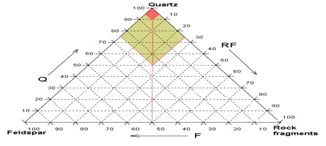
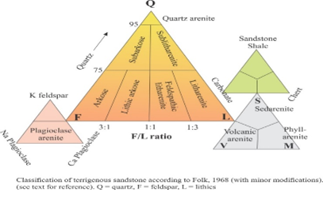
Based on Folk’s (1980) sandstone classification, the samples fall within the sublthic sandstone as seen in Figure 5, and their textural maturity ranges from submature to texturally matured.
(a)
(b)
Figure 5: (a) Sandstone classification plot showing the category of the Yolde sandstone studied,
(b) Sandstone classification scheme adopted after Folk, (1980)
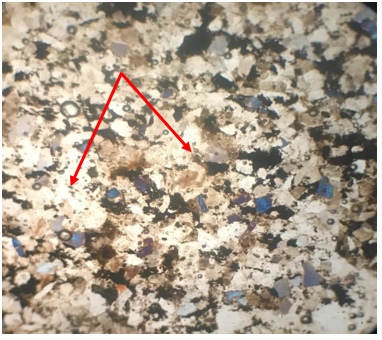
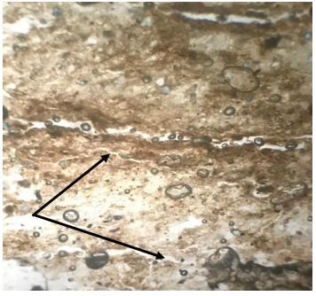
Petrographic analysis revealed that much of the Yolde’s Sandstone primary porosity has been destroyed by mineral cementation. However, secondary porosity has been identified in some samples. (Fig 6)
(a) (b)
Figure 6. (a) Photomicrograph of sample DM2 showing mineral cementation destroying porosity as indicated by the red arrows, (b) Photomicrograph of sample DM1 showing secondary porosity created by fissures as indicated by the black arrows.
Permeameter analysis
A total of eight (8) core samples were prepared and subjected to falling head permeameter and porosimeter analysis in order to determine their porosity and permeability. The results are presented in Table 3.
Table 3: Summary of porosity and permeability results
| Sample ID | Permeability (Md) | Porosity (%) |
| DM3 | 17.8 Poor | 7 Poor |
| DM4 | 12.9 Poor | 17 Good |
| DM5 | 29.7 Moderate | 22 V. Good |
| DM6 | 10.4 Poor | 18 Good |
| DM7 | 91.4 Good | 6 Good |
| DM12 | 486 V. Good | 26 Poor |
| DM13 | 108 Good | 18 V. Good |
| M13B | 44.2 Moderate | 17 Good |
As seen from Table 3, the porosity evaluated ranged between 6% – 26%, with an average of 17%, while the permeability ranged from 12.9 – 108 mD.
DISCUSSION
Reservoir rocks, which play a critical role in oil and gas exploration and production, possess two essential attributes – porosity and permeability. Porosity refers to the void spaces within the rock that can store fluids such as oil and gas, while permeability represents the ability of these fluids to flow through the interconnected pore spaces. Porosity and permeability are dependent upon the physical properties of the reservoir rocks, which are determined by their mineralogical and textural maturity. Petrographic analysis helps to identify the mineral composition and texture of the rocks, while Granulometric analysis determines the grain size distribution. Both of these analyses are used to understand the porosity and permeability of the reservoir rock, which are crucial factors in the success of oil and gas exploration.
The granulometric analysis shows that the sorting in the Yolde Sandstone varies from poor to moderately well-sorted. The moderately well-sorted sandstones are found in the thick sandstone facies of the prodelta sands and distributary mouth bar deposits. On the other hand, poor sorting is associated with the floodplain deposits and mixed sands of braided channel deposits (as shown in Fig. 8). The skewness values for the Yolde Sandstone are generally positive, which suggests that although the parking of the grains is generally good, there may have been crystallizations of secondary minerals in the voids. This could have led to a loss of porosity to some extent. Positive skewness indicates the occurrence of fine materials between grains.
Petrographic analysis showed that the Yolde Sandstone is grain-supported and texturally and mineralogically mature based on mineral composition and grain shape.
CONCLUSION
The purpose of this research is to evaluate the reservoir potential of the Cretaceous Yolde sandstone in the Doma stream area of the Gongola sub-basin, located in the northern Benue trough of Nigeria. The study utilized sedimentological and petrophysical methods to determine the sediments’ porosity and permeability and to reconstruct the Cretaceous Yolde formation’s paleo-depositional environments. As a result of these investigations, the following discoveries were made:
- The Yolde sediment in the studied area was formed in fluvial (braided river) and transitional (deltaic) environments. The studied section shows multiple cycles of progradation and retrogradation but can be summarized by a one-cycle facies model which indicates prograding facies succession that ranges in thickness for several meters and coarsens upward sequence. This depositional model is capable of producing both permeable and impermeable sediments which have the potential to deposit reservoir units and also form stratigraphic traps.
- The sandstone samples analyzed contain mostly quartz, feldspars, and mica as framework elements with other matrix and cement. The texture of these sandstones indicates that they are poorly to well sorted, with moderately well sorting dominant. The grain shapes vary from subangular to subrounded with subrounded shapes being the most dominant, and the sphericity is predominantly high, suggesting that the samples studied are texturally matured. The framework composition of these sandstones varies, and quartz comprises an average of 86% of the framework grains making them mineralogically matured.
- The graphic mean size of the various samples ranges from 1.64ø – 2.65ø, which means medium to fine-grained sands. The fluctuation of the values may reflect a change in the strength of the deposition medium. The standard deviation values indicate that the samples ranged from moderately well-sorted (0.59ø) to poorly sorted (1.27ø) with an average of 0.86ø, implying that the whole formation is moderately sorted.
- The samples analyzed have skewness values ranging from 0.29ø to 1.33ø, indicating positively fine-skewed to strongly fine positively skewed values, respectively. However, strongly positively skewed values predominate with an average of 0.83ø. This may be because much of the silt and clay were removed by the current. The kurtosis values for the various samples range from 0.95ø to 1.53ø (Mesokurtic to very Leptokurtic) with an average of 1.00ø (Mesokurtic).
- The porosity of the sandstones evaluated ranges between 6% – 26%, with an average of 17%, while the permeability ranges from 12.9 – 108md. Bivariate analysis shows that the sandstones studied were mostly formed in river systems, with only a few samples formed on beaches and barrier islands.
Based on the significant thickness of the exposed Sandstone unit of the Yolde formation, and the petrophysical evaluation of the Yolde Sandstones, it indicates a considerable amount of porosity and permeability. This level of porosity and permeability is comparable to that of many well-known reservoir rocks found in prolific petroleum basins. Therefore, the Yolde Sandstone has the capacity to store and transmit hydrocarbons in commercial quantities.
REFERENCES
- Abubakar, M. B., 2014. Petroleum potentials of the Nigerian Benue trough and Anambra Basin: a regional synthesis. Nat. Resour. 5 (1), 25e58.
- Benkhelil, J. (1989). The origin and evolution of the Cretaceous Benue Trough (Nigeria). J Afr Earth Sci; 8:251–82.
- Boggs, S. Jr., (2006). Principles of Sedimentology and Stratigraphy (4th eds.). Prentice Hall, Upper Saddle River, New Jersey, 1 – 139p.
- Carter, J. D., Barber, W., Tait, E.A., Jones, G.P., (1963). The geology of parts of the Adamawa, Bauchi and Bornu Provinces in Northeastern Nigeria. Geol. Surv. Niger. Bull. 30, 53e61.
- Folk, R. L., (1974). Petrology of Sedimentary rocks. Austin Texas, Hemphill Book Store In: Scolle P.A. (Ed), A Colour illustrated guide to constituents, textures, cement and porosities sandstones and associated rocks. American Association of Petroleum Geologists Memoir, 28, p170.
- Folk, R.L., Ward, W. C., (1957). Brazor River Basin: study the significance of grain size parameter. J Sediment Pet; 31:514–29.
- Krumbein W.C., Pettijohn, F.J., (1938). Manual of sedimentary petrography. Appleton Century Crofts, New York, 549 p,
- Lirong, D., Dingsheng, C., Zhi, L., Zhiwei, Z., Jingchun,W., (2013). Petroleum geology of the Fula sub-basin, Muglad Basin, Sudan. J. Pet. Geol. 36, 43e60.
- Nabage, N., Maigari, A.S., Abdullahi, I., Yelwa, N.A., Aliyu, M., & Saamson, S., (2019). Reservoir Potential of Gombe Sandstone around Kalshingi Area, Northern Benue Trough, N-E, Nigeria. Science Forum (Journal of Pure and Applied Sciences).
- Nichols, G. J., (2009). Sedimentology and Stratigraphy. John Wiley and Sons, New York, p. 452.
- Obaje, N. G., Wehner, H., Abubakar, M.B., Isah, M.T., (2004). Nasara 1 well Gongola Basin (Upper Benue trough, Nigeria): source rock evaluation. J. Petrol. Geol. 27
- Offodile, M. E., (1976). The Geology of the Middle Benue, Nigeria. Paleontological Institution of the University of Uppsala, Sweden. Special Volume 4, 1e116.
- Sarki Yandoka, B. M., Abdullah, W.H., Abubakar, M.B., Hakimi, M.H., Adegoke, A.K., (2015). Geochemical characterisation of Early Cretaceous lacustrine sediments of Bima Formation, Yola Sub-basin, Northern Benue Trough, NE Nigeria: organic matter input, preservation, paleoenvironment and paleoclimatic conditions. Mar. Petrol. Geol. 61, 82e94.
- Sarki Yandoka, B. M., Abubakar, M.B., Abdullah, Wan Hasiah, Amir Hassan, M.H., Adamu, Bappah U., Jitong, John S., Aliyu, Abdulkarim H., Adegoke, A.K. (2014). Facies analysis, palaeo environmental reconstruction and stratigraphic development of the Early Cretaceous sediments (Lower Bima Member) in the Yola Sub-basin, Northern Benue Trough, NE Nigeria. J. Afr. Earth Sci. 96, 168e179.
- Shettima, B., Buba, I., Mohammed, S., Yunusa, A., Hamidu, H., Usman, A., (2016). Reservoir Potentials of the Cretaceous Gombe Sandstone, Gongola Basin, Upper Benue Trough, North Eastern Nigeria. IOSR Journal of Applied Geology and Geophysics (IOSR-JAGG).
- Shettima, B., Bukar, M., Kuku, A., Shettima, B., & Kamale, I., (2020). Incised Valley Depositional System of the Cretaceous Yolde Formation of the Gongola Sub-basin Northern Benue Trough N.E. Nigeria. European Journal of Engineering Research and Science.
- Tukur, A., Samaila, N.K., Grimes, S.T., Kariya, I.I., Chaanda, M.S., (2015). Two member subdivisions of the Bima Sandstone, upper Benue trough, Nigeria: based on sedimentological data. J. Afr. Earth Sci. 104, 140e158.
- Zaborski, P., Ugodulunwa, F., Idornigie, A., Nnabo, P., Ibe, K., (1997). Stratigraphy and structure of the Cretaceous Gongola Basin, Northeast Nigeria. Bull Centre Rech Explo Prod. Elf Aquitaine; 21(1):154–85.