
Harnessing Geospatial Techniques for Designing Lakeshore Circumferential Green Parks
- Rick Jayson A. Tatlonghari
- 281-302
- Mar 3, 2025
- Geology
Harnessing Geospatial Techniques for Designing Lakeshore Circumferential Green Parks
Rick Jayson A. Tatlonghari
Planning Section, GEOCORP, Los Baños, Laguna, Philippines
DOI: https://doi.org/10.51244/IJRSI.2025.12020025
Received: 23 January 2025; Revised: 31 January 2025; Accepted: 03 February 2025; Published: 03 March 2025
ABSTRACT
Laguna de Bay, the largest inland body of water in the Philippines, is an essential resource for millions of Filipinos. However, the lake has suffered severe environmental degradation due to rapid industrialization, population growth, and mismanagement, resulting in pollution and declining water quality. Despite efforts such as the development of the Laguna de Bay Basin master plan, significant improvements remain elusive. This study proposes the creation of Lakeshore Circumferential Green Parks as a practical and sustainable solution. By integrating green infrastructure and promoting environmental stewardship at the barangay level, this initiative offers a strategy for revitalizing Laguna de Bay. Geospatial techniques were employed to assess the lake’s current conditions and propose a design that optimizes legal easement areas for ecological restoration. This concept seeks to convert the shoreland into a multifunctional green area, encouraging biodiversity, improving recreational options, and enhancing environmental resilience. The green park is expected to foster community engagement, promote environmental education, and strengthen the connection between local residents and the lake. It will provide multiple benefits, including enhanced air quality, flood control, and recreational spaces, while contributing to the economic development of surrounding areas. By prioritizing sustainability and inclusive participation, the initiative aims to create a resilient and thriving environment for future generations, ensuring the long-term preservation of Laguna de Bay.
Keywords: Laguna de Bay, Laguna Lake, Lakeshore, Green Park, Urban Planning, Geospatial, GIS, Remote Sensing, Sustainable Development, Climate Change
INTRODUCTION
Laguna de Bay, commonly known as Laguna Lake, is the largest inland body of water in the Philippines and one of the largest lakes in Asia, ranking approximately tenth globally and the third largest in Southeast Asia, following Tonle Sap in Cambodia and Lake Toba in Sumatra. Spanning approximately 911 square kilometers, the lake is a vital source of livelihood, freshwater, and recreation for millions of Filipinos (Laguna de Bay | Lake, Philippines, 2025). It plays a crucial role in the economic vitality of Metro Manila and supports the ecosystems of Laguna and Rizal provinces.
Beyond its ecological and economic significance, Laguna de Bay serves multiple functions. In several areas, it acts as a vital transportation corridor connecting towns and cities along its shoreline, a role it has fulfilled since the Spanish era as a passenger boat navigation route. The lake also supplies water to the Kalayaan Pumped Storage Hydroelectric Project in Kalayaan, Laguna, while supporting local fisheries and serving as a crucial stopover for migratory birds. Additionally, it is a popular recreational area and an essential irrigation source for agricultural lands. In places like Los Baños, the lakefront has been integrated into municipal parks, allowing residents to enjoy its scenic views throughout the day.
However, population expansion, rapid industrialization, and resource misallocation have significantly degraded Laguna de Bay (Lakepedia, 2024). Various stakeholders attempt to influence policy and law enforcement for their own benefit, leading to mismanagement and environmental harm. Poor waste disposal practices, water contamination, and unchecked pollution—especially from commercial and industrial zones—have transformed the lake into a vast sewer, characterized by offensive odors and heightened water turbidity. Addressing these challenges requires urgent and coordinated efforts to restore and protect this invaluable natural resource.
Since the establishment of the Laguna Lake Development Authority (LLDA) in 1966, the Philippine government has exerted so much effort to restore the quality of the lake. The formulation of the Laguna de Bay Basin: Land and Water Use and Physical Development Plan 2011-2020 and the Laguna Lake Master Plan (2016 and Beyond: Towards Climate Resilience and Sustainable Development) are evident documents that show that a lot of minds are helping the institutions to restore the ecological quality and economic benefits of the lake. However, there has been no noticeable improvement in water quality or widespread enforcement of the law, particularly under Article 51 of PD 1067, also known as the Water Code of the Philippines.
Recognizing the urgent need for its restoration and rehabilitation, LLDA has developed a master plan in 2016 that remains open to new strategies, particularly for lakeshore barangays that significantly impact the lake’s health. Currently, LLDA includes particular procedures and standards for developing and managing shoreland areas to promote environmental protection and resource sustainability. This involves the shoreland development clearance (SDC) process, which necessitates verification of the mandatory 12.50-meter elevation above sea level for sites within lakeshore barangays. The goal is to avoid flooding and conserve the lake’s ecosystem while still allowing for appropriate development. Furthermore, adherence to these guidelines ensures that local communities can thrive without compromising the natural resources that support their livelihoods. By balancing development with ecological preservation, the LLDA aims to foster a sustainable future for both the lake and the surrounding populations.
Meanwhile, numerous initiatives exist to preserve lakes worldwide, yet research continues to highlight the persistent and detrimental impacts on their ecosystems. One approach to mitigating these effects involves replenishing essential minerals like calcium or introducing beneficial bacteria to improve water quality. These bacterial treatments help break down pollutants responsible for murky water, foul odors, and sludge accumulation. However, by reducing the availability of nutrients that sustain weeds and algae, they can inadvertently disrupt the ecological balance over time (Advanced Water Technologies, 2018). Given these environmental concerns, alternative nature-based solutions are being explored. One promising strategy is the creation of green spaces to enhance the surrounding environment. This initiative, known as the Green Revolution at Laguna Lake, integrates sustainable architecture, environmental awareness, and innovative energy solutions. These efforts can significantly improve the ecological health of Laguna de Bay, ensuring the well-being of future generations in the surrounding areas, including parts of Metro Manila.
The conservation and restoration of Laguna de Bay require a multifaceted approach, with the scientific community—particularly the academic sector—playing a crucial role. By providing essential evidence, researchers help shape effective policies for the lake’s revitalization. To achieve realistic and sustainable development, it is imperative to consider and contextualize both biophysical and social factors in policymaking and program execution (Lasco and Javier, 2017). In line with this, and in addition to the mandatory elevation of 12.50 meters above sea level for all development projects along the Laguna de Bay lakeshore, this study proposes the establishment of Lakeshore Circumferential Green Parks. Utilizing a simple geospatial technique, the proposed green park design aims to optimize the legal easement of the shoreland efficiently and sustainably, ensuring long-term ecological balance. By integrating nature-based solutions and fostering inclusive participation among local government units, communities, and key stakeholders. This initiative ensures that shoreland development aligns with environmental conservation efforts. Moreover, it promotes community engagement and strengthens the connection between local residents and their natural surroundings. Prioritizing green spaces and accessibility will not only enhance the overall quality of life for residents but also safeguard the fragile lakeshore ecosystem, fostering a sustainable and resilient environment for future generations.
OBJECTIVES
The general objective of this study is to demonstrate the effectiveness of simple geospatial techniques in rapid assessments and urban planning in shoreland areas, supporting sustainable development in municipalities and provinces in Laguna de Bay and parts of Metro Manila.
Specifically, the study’s objectives are:
- Utilize simple geospatial techniques to conduct a rapid assessment of Laguna de Bay, highlighting existing conditions, challenges, and potential for sustainable development.
- Employ geospatial analysis to develop a sustainable urban development design plan for the Laguna de Bay area, particularly focusing on the lakeshore areas.
- Evaluate the feasibility, practicality, and potential impact of the proposed sustainable urban development design using geospatial data, and analyze the potential benefits for the Laguna de Bay area.
METHODOLOGY
a. The Study Area
Laguna de Bay, often called Laguna Lake, is the Philippines’ largest lake. The lake spans an area of 911–949 km² (352–366 sq mi) and has an average depth of about 2.8 meters (9 ft 2 in). The shoreline of the lake extends for 220 km (140 mi), exhibiting a crow’s foot shape (Map 1).
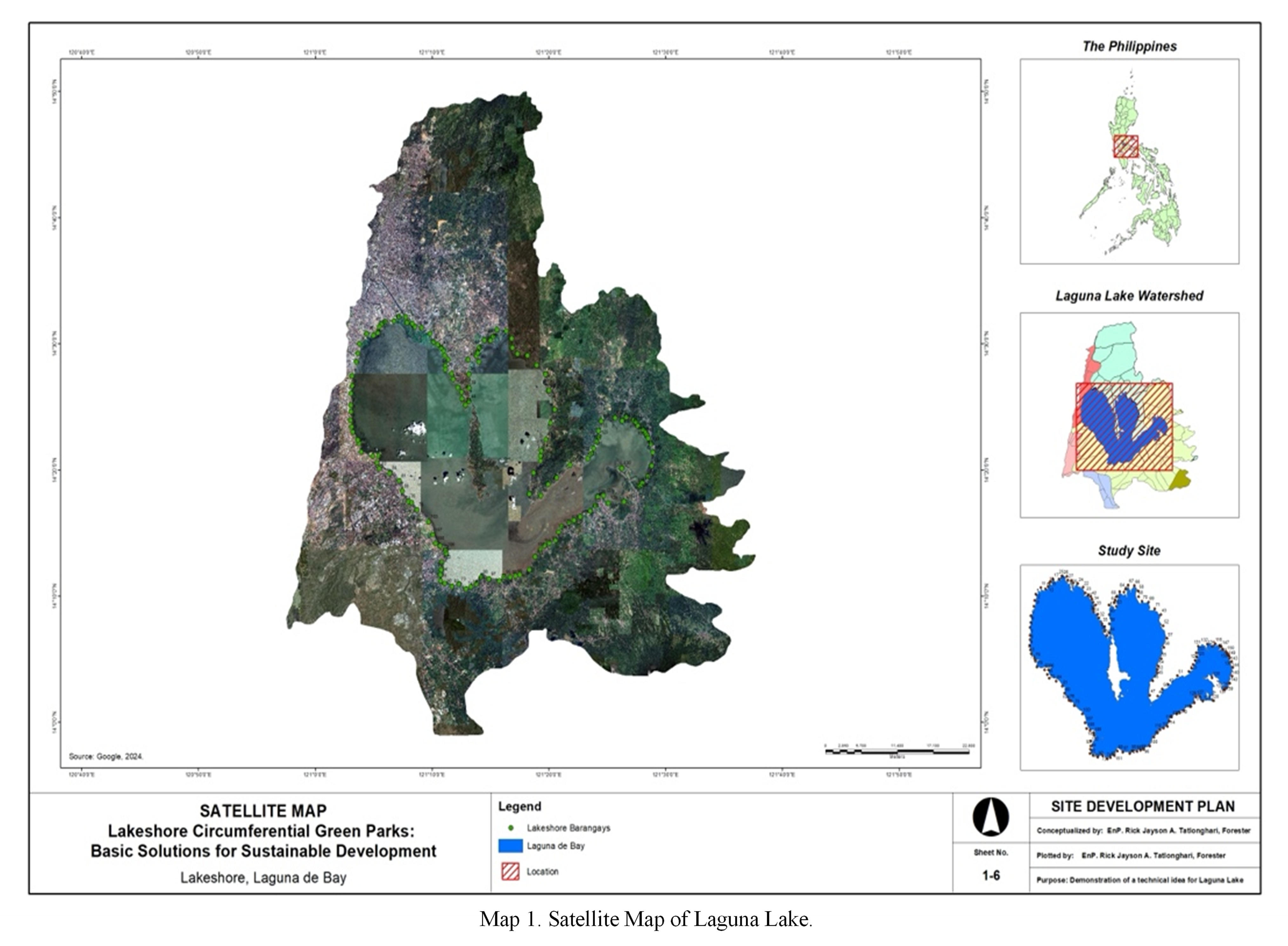
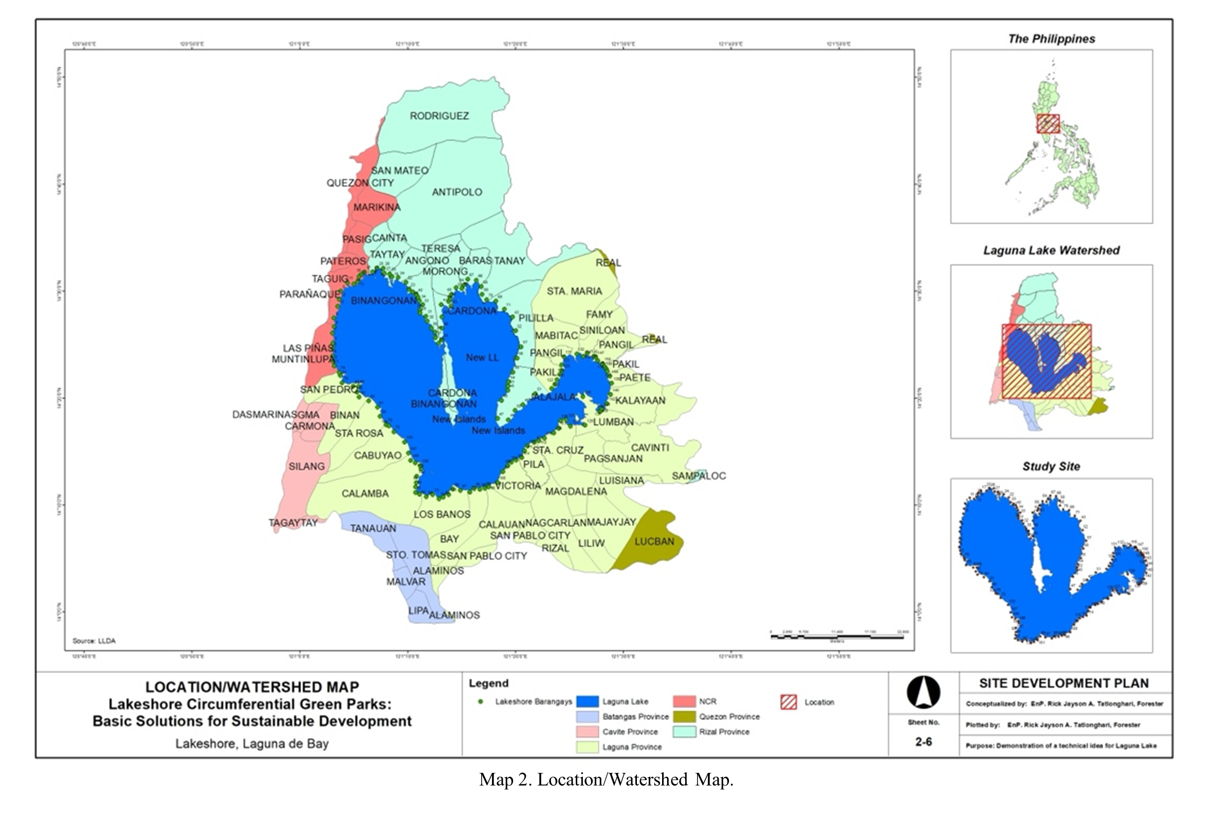
It is located southeast of Metro Manila, between the provinces of Rizal to the north and Laguna to the south. In the north, the lake contains two peninsulas and numerous islands. The largest island, Talim, is thickly populated. The lake’s southern shore is home to communities such as Calamba, Los Baños, Bay, Calauan, Victoria, Pila, and Santa Cruz. The eastern bay (Lumban, Kalayaan, Paete, Pakil, Pangil, Siniloan, and Mabitac) is less populous than the western section, which is intensively developed (San Pedro, Biñan, Santa Rosa, and Cabuyao). Twelve cities, 49 municipalities, and several villages encircle the lake, housing a population of approximately 6 million. The lake’s watershed area includes the provinces of Rizal and Laguna, as well as towns in Batangas, Cavite, Quezon, and Metro Manila. The largest of its 21 tributaries is the Pagsanjan River, which supplies 35% of its water. Other notable rivers are the Balanak, Marikina, Mangangate, Tunasan, and San Pedro. Despite its numerous tributaries, the lake has only one major outflow: the Pasig River, which flows into Manila Bay (Map 2) (Lakepedia, 2024).
b. Data Gathering and Analysis
Building on data and insights from previous studies, a rapid assessment of the Laguna de Bay’s condition was carried out. This was complemented by an in-depth spatial and investigative analysis utilizing Geographic Information System (GIS) and Remote Sensing (RS) to provide a comprehensive evaluation of the area. Generally, the methodology for this study consists of three stages: (1) data acquisition from previous studies and available geodatabases and satellite harvesting (collection of secondary and primary data); (2) geoprocessing, manipulation, cleaning, analysis, and storage for spatial data science (geodata engineering); and (3) the site’s evaluation using spatial analysis, encompassing current conditions, obstacles, sustainable development potential, and visualizing the suggested design plan (geovisualization).
All the maps used in this study were gathered from the internet and previous studies. Locating densely populated lakeshore areas and delineating current lakeshore shapes was done through Landsat 8 and Landsat 9 through the U.S. Geological Survey (USGS). Harvested satellite images were subjected to algorithmic rasterization using QGIS with 10,000 tile sizes and 1 map unit per pixel. A simple multi-criteria analysis based on the hazards developed by DENR-MGB RIVA and used by Laguna Province was adopted to identify areas that are prone to flooding and liquefaction (based on available data only) that needed to be considered and to rate areas according to a set of criteria in determining risk and exposure areas that need to be considered in sustainable development.
All the gathered maps were digitized, edited, manipulated, and analyzed using open-source GIS software, particularly QGIS. Analog maps from the internet, after being rectified into WGS 1984 using georeferencer, were digitized using on-screen digitizing to employ large-scale mapping[1] to have a more accurate map since a wrong map will result in the wrong plan, while readily available shapefiles undergo data engineering to clean and standardize the boundaries and coordinates to be used. For spatial analysis, basic spatial data science was applied, while for investigative analysis, 3D analysis was used.
Specifically, the following processes were conducted:
- Satellite harvesting was done using QGIS and Python.
- Georectification of downloaded available thematic maps using the QGIS georeferencer.
- On-screen digitizing was used to delineate boundaries and the study area.
- Output was manipulated using geoprocessing and some other plugins in QGIS and Python to delineate areas and other important spatial data and information.
- Construction of a three-dimensional model to have a bird’s-eye view of the area was done using a 3D analyst (Qgis2threejs) for better visualization of reality.
- Map layout for presentation and reference.
LIMITATIONS AND SCOPE OF THE STUDY
The rapid urban assessment and design planning in this study are constrained by the available socio-demographic, environmental, and economic data collected for the entire lake. Additionally, the study relies solely on thematic maps at a scale of 1:250,000, including soil erosion, high-risk multi-hazard maps, population density, political boundaries, built-up areas, rivers, lakes, slopes, and land use. To facilitate rapid assessment and planning, only the latest Landsat 8 and 9 imagery from the USGS and a digital elevation model from NASA were utilized.
Given limitations in time, data availability, and financial resources, this study specifically focuses on the development of lakeshore circumferential green parks along Laguna de Bay. The proposed use of easements and shoreland development is framed within the three pillars of sustainability—economic, social, and environmental—to address interconnected challenges and promote a balanced, sustainable approach to urban planning.
REVIEW OF RELATED LITERATURE
A. Importance of Lake Restoration
Laguna de Bay basin (or region) is considered the most significant, vibrant, and rapidly expanding economic hub in the country due to its numerous applications and advantages. It serves as the receptacle for the overflow of Metro Manila’s population and the expansion of urbanization and industrialization. Because of the region’s development, the lake has seen escalating levels of pollution from agricultural, industrial, and home effluent. The exponential increase in population may lead to scarcities in food and water, exacerbating traffic congestion and causing environmental deterioration, all of which would profoundly affect Laguna de Bay and its surrounding areas (Laguna Lake Development Authority, 2016).
For a variety of reasons, the restoration of the lake is of utmost importance. From an ecological standpoint, it aids in biodiversity conservation and the long-term viability of aquatic environments. Lakes play a vital role in the hydrological cycle because they serve as important storage areas for freshwater. Lakes offer social benefits by providing possibilities for recreation, enhancing the visual appeal of landscapes, and contributing to local economies through tourism and fisheries. From a health standpoint, the process of restoring lakes guarantees the purity of water for consumption, swimming, and other leisure activities, thereby diminishing the hazards linked to waterborne contaminants and illnesses. Lake restoration refers to the methods and efforts employed to restore degraded or contaminated lakes to a healthier condition. This is urgently needed in the case of Laguna de Bay to ensure the long-term viability of the lake’s ecosystems, improve the quality of the water, and maintain its worth for future generations.
Poikane et al. (2024) highlight that the most effective and widely utilized approach for lake restoration is reducing nutrient loading, both from external catchment sources and within the lake itself. In contrast, their study indicates that hydrological alterations and nature-based solutions are employed far less frequently. Moreover, their analysis reveals that strategies for managing non-native invasive species are rarely implemented, as they are often perceived as ineffective. Given such limitations, a comprehensive strategy that tackles the underlying factors leading to deterioration and takes into account the wider context of the surrounding watershed is needed to rejuvenate lakes to their previous state of vigor (Western Environmental Liner, 2024).
Moreover, the process of lake restoration aids in the preservation of ecological equilibrium and sustains a diverse range of plant and animal species (National Academies of Sciences, Engineering, and Medicine, 1992; Tammeorg, 2024). Healthy lakes enhance local economies by fostering heightened tourism, recreation, and property values. Additionally, they play a crucial role in economic endeavors such as fishing and transportation (Tammeorg, 2024; Western Environmental Liner, 2024). Lakes function as leisure spaces, fostering physical exertion and psychological welfare. Additionally, they have a vital role in establishing and preserving a sense of community identity and cultural history (Western Environmental Liner, 2024). In summary, lake restoration is essential for improving the health of lakes, which has positive impacts on both nature and human societies.
B. Laguna de Bay Basin Master Plan[2]
Laguna Lake is exclusively overseen by a specialized agency of the Philippine government, making it unique in the country. The formation of the Laguna Lake Development Authority (LLDA) in 1966 as a quasi-government agency responsible for the preservation, development, and sustainability of Laguna de Bay and its 21 major tributary rivers aimed to establish a structured framework for implementing regulations governing the utilization of lakes. The purpose of the organization is to stimulate the implementation of integrated water resource management in the Laguna de Bay Region, which is sensitive to climate change. The primary objectives are to preserve the ecological integrity of the region and promote sustainable economic growth. The LLDA is responsible for the development and implementation of measures to manage and protect the environment, monitor water quality, preserve natural resources, and promote community-based management of natural resources. It mandates the regulation of fish pens and cages and the implementation of the environmental user fee system. LLDA collaborates with local governments to manage and process both industrial and domestic waste, as well as assist in determining the permissible amount of water extraction for specific uses (Vargas-Nguyen, Vanessa, 2015).
The LLDA has developed a Master Plan which outlines a comprehensive strategy aimed at promoting sustainable development and climate resilience in the Laguna de Bay region. Its primary objectives are:
- Environmental Protection: Reducing pollution levels by implementing stricter regulations on industrial and agricultural waste disposal;
- Sustainable Development: Promoting eco-friendly practices and technologies to ensure the long-term sustainability of the region;
- Climate Resilience: Enhancing the region’s resilience to climate change through various adaptation and mitigation measures; and
- Community Engagement: Involving local communities in the planning and implementation process to ensure their needs and concerns are addressed.
While the key components of the said master plan are:
- Environmental User Fee System (EUFS): A system that imposes fees on industries and businesses that discharge wastewater into the lake, encouraging them to adopt cleaner practices.
- River Rehabilitation Program: Initiatives aimed at restoring and maintaining the health of the rivers and tributaries flowing into Laguna de Bay.
- Zoning and Management Plan (ZOMAP): A plan that designates specific zones for different uses, such as residential, commercial, and agricultural areas, to minimize environmental impact.
- Laguna de Bay Carbonshed Project: A project focused on enhancing the lake’s capacity to sequester carbon, contributing to climate change mitigation.
The Laguna de Bay Basin Master Plan is implemented through a combination of regulatory measures, community participation, and partnerships with various stakeholders, including government agencies, private sectors, and local communities. The plan is open for updates to incorporate new strategies and address emerging challenges.
The expected outcomes of the master plan once implementation was successful are the following:
- Improved water quality and reduced pollution levels in Laguna de Bay.
- Enhanced biodiversity and ecosystem health in the region.
- Increased awareness and participation of local communities in environmental conservation efforts.
- Strengthened resilience to climate change impacts, such as flooding and drought
The master plan is a crucial step towards ensuring the sustainable development and environmental protection of the Laguna de Bay region. By addressing the unique challenges faced by the area, the plan aims to create a healthier and more resilient environment for current and future generations.
The aforementioned master plan regards Laguna Lake’s water resources as a driving force for social and economic progress, not only within the basin but also for the entire country. Furthermore, the master plan views these resources as a crucial element in guaranteeing environmental sustainability. Therefore, the basin plan will be incorporated into the planning hierarchy, spanning from the national level down to the municipal level. Hence, it is imperative to horizontally synchronize the plan with the development planning, which encompasses diverse development concerns under the revised master plan.
C. Green Parks
Green parks are vital elements of urban and rural settings, offering several ecological, social, and economic advantages. Several articles (Manila Bulletin, 2025; Green-Ecolog, 2024; Schottland, 20219, Gibbens, 2019) highlight the significance of green parks along lakeshores, addressing ecological, economic, and social dimensions.
- Ecological Importance: Green parks function as natural air purifiers by sequestering pollutants and emitting oxygen; therefore, they enhance air quality. Moreover, green spaces offer habitats for diverse flora and fauna, enhancing biodiversity and promoting ecological stability. Arboreal and vegetative elements in green spaces contribute to alleviating the urban heat island phenomenon by offering shade and cooling surrounding areas (Cameron McCosh, 2024).
- Health and Well-being: People widely recognize the health advantages linked to green parks. Studies have demonstrated that access to green spaces can alleviate stress, boost mental health, and improve general well-being. Engaging in regular physical activities, such as walking, jogging, and cycling in parks, aids in the prevention of chronic diseases and enhances physical fitness. The presence of green parks promotes outdoor activities and social connections, vital for mental and emotional well-being. Furthermore, the visual appeal of green parks imparts a sense of serenity and repose, providing a necessary respite from the frenetic pace of metropolitan existence(Manila Bulletin, 2025).
- Social and Cultural Benefits: Green parks serve as social hubs that promote community involvement and harmony. They offer a venue for individuals of many ages and backgrounds to convene, converse, and participate in leisure pursuits. Parks frequently organize cultural events, festivals, and community activities, enhancing the cultural tapestry of the region and fostering social inclusion. The accessibility and inclusion of green parks are vital for fostering social fairness, as they provide free or low-cost recreational opportunities for all individuals, irrespective of socioeconomic position (Manila Bulletin, 2025).
- Economic Value: The economic influence of green parks transcends their direct ecological and social advantages. Well-maintained parks may elevate property prices, attract tourism, and invigorate local economies. Green parks yield financial benefits for communities by offering ecological services, like stormwater management and flood mitigation. The presence of green spaces can also reduce healthcare costs by promoting healthier lifestyles and improving public health. Parks also generate employment opportunities in landscaping, maintenance, and recreation, thereby enhancing local labor markets (Cameron McCosh, 2024).
- Climate Change Mitigation and Adaptation: Green parks play an important role in mitigating climate change. Trees and vegetation elements in parks trap carbon dioxide, contributing to the mitigation of greenhouse gas emissions. Green parks augment urban resilience by offering natural barriers against extreme weather phenomena, including floods and heatwaves. They enhance water management by promoting groundwater recharge and mitigating runoff. Integrating sustainable design features, green parks can exemplify climate-resilient urban development (Schottland, 2019; Gibbens, 2019).
- Challenges and Opportunities: Notwithstanding their countless advantages, green parks encounter obstacles like land-use pressures, pollution, and insufficient funds for maintenance. Urbanization and population expansion can jeopardize the availability and accessibility of green places. Nonetheless, these issues also offer potential for new solutions, like the development of green roofs, vertical gardens, and the use of green infrastructure in urban planning. Cooperative initiatives among governments, communities, and the corporate sector can aid in the preservation and enhancement of green parks (Manila Bulletin, 2025).
Green places are crucial for providing ecosystem services. Public green areas, like Burnham Park in Baguio City in the Philippines, facilitate social interaction among individuals from different socioeconomic backgrounds, including the wealthy, the disadvantaged, the elite, and the working class. Additionally, many perceive these public green places as a way to get a decent income. Some green spaces function not as locations for moral rejuvenation but rather as areas for mental and physical leisure (Saloma, C., 2021).
The Department of Budget and Management (2018) asserts that the key to achieving livability and sustainability lies in the transformation of unused spaces into green spaces. Therefore, the development of an interconnected green park in the shoreland of Laguna Lake not only will provide essential ecosystem services but also foster a sense of community inclusivity and will surely improve the quality of life for current and future generations of each lakeshore barangay.
D. Sustainable Development
Sustainable development (SD) has become a widely accepted and influential approach to development. The concept has garnered widespread attention, unlike other development concepts, and seems likely to continue as the dominant development paradigm for an extended period. Different scholars have linked the concept of development to a range of meanings, interpretations, and theories (Mensah, J., & Ricart Casadevall, S., 2019).
According to Mazza (2021), classical economists laid the foundation for the sustainability notion. The concept of sustainable development was already a topic of discussion in the debate on limitations and expansion. Malthus, Ricardo, Mill, Hicks, Pigou, and numerous other scholars had forecasted that the depletion of natural resources would result in a deceleration and eventual halt of economic expansion. Sustainable development encompasses the deliberate and systematic planning and execution of economic, social, and environmental initiatives with a primary focus on safeguarding the environment and ensuring long-term sustainability.
In 2015, during the 70th General Assembly of the United Nations, all United Nations Member States agreed upon the Sustainable Development Goals (SDGs), also referred to as the Global Goals. This agreement, known as the “Transforming Our World: The 2030 Agenda for Sustainable Development” resolution, outlines a common plan for achieving peace, prosperity, and environmental sustainability. It tackles worldwide issues like poverty, inequality, climate change, and environmental degradation. The Sustainable Development Goals (SDGs) have the objective of eradicating poverty, safeguarding the environment, and promoting peace and prosperity for everyone by the year 2030 (United Nations, 2015). Regarded as the most ambitious international agreement ever achieved by the United Nations, since then, the planning process has primarily used this agreement as a framework for setting aims and objectives to eliminate poverty and attain sustainable development at a local level.
E. GIS and Remote Sensing for Sustainable Urban Planning
In contemporary times, geographic information systems (GIS) are widely regarded as an essential field of study within the realm of information technology. It is defined as an organized collection of hardware, software, geographic data, and personnel designed to efficiently capture, store, update, manipulate, analyze, and display all forms of geographically referenced data and information for a particular set of purposes (Tatlonghari, 2024). Remote sensing, on the other hand, collects data on a worldwide scale through satellites, on a local scale through airplanes, or, more recently, through smaller unmanned aerial vehicles (UAVs, often known as drones) and handheld devices (van der Linden et al., 2018).
GIS-assisted spatial planning may contribute to environmentally acceptable development and help resolve conflicts that would otherwise arise (Babu, 2000). People widely use GIS to assess environments and scenarios. This technology facilitates the simple organization and easy graphic presentation of geographic data, both spatially and temporally (Tripathy, 2000).
Sustainable urban planning is one of GIS’s primary uses. Urban planners use GIS as a spatial database and tool for conducting research and presenting their findings. Different stages, levels, sectors, and parts of urban planning can utilize GIS in different ways. With the ease of use and features of GIS software getting better and the price of GIS tools going down quickly, GIS has become a useful and affordable planning information system. It’s becoming more and more important to plan networks that will help people perform their jobs well. The increasing integration of GIS with planning models, representations, and the web will enhance its utility in town planning. Today, the primary challenges of using GIS in urban planning are not technical but rather revolve around information accessibility. Rapidly evolving regulations and a shortage of trained personnel hinder the effective utilization of GIS, limiting its full potential in decision-making and development (Rudrawar, 2020).
Often a challenge is the availability of useful information that can assist planning decisions; various studies have underlined the importance of environmental evaluations offering spatially explicit data in a timely, cost-effective, and repeatable manner. One such element influences urban planning. Using remote sensing (RS) and a geographic information system (GIS) to extract important data could be one way to help overcome the challenges mentioned above, since GIS and RS in land use planning for identifying suitable sites require desirable, accurate, timely, accessible, comprehensive, reliable, and affordable spatial information. Hence, the use of geographic information systems to provide such information is imperative (Tatlonghari, 2002; Wellman et al., 2020).
Specifically, the use of GIS and remote sensing in urban planning for Laguna de Bay is crucial. GIS and remote sensing help in accurately mapping land use and land cover changes over time, essential for understanding urban expansion and its impact on natural resources (Mather & Koch, 2011). These technologies allow for continuous monitoring of environmental changes, such as deforestation and urban sprawl, enabling informed decisions to mitigate negative impacts (Campbell & Wynne, 2011). Furthermore, since Laguna de Bay is a vital water resource, GIS and remote sensing assess the hydrologic effects of urbanization, crucial for sustainable water management (Maidment, 2002). Analyzing spatial data helps planners study urban growth patterns and predict future expansion, aiding infrastructure and service planning (Clarke, 2003). Also, accurate topographic and hydrological data from GIS and remote sensing help identify flood-prone areas and develop flood mitigation strategies (Burrough & McDonnell, 1998). Data from GIS and RS support the development of policies and plans for sustainable urban development, providing a scientific basis for decision-making (Batty, 2005). Lastly, interactive maps and visualizations from GIS and remote sensing engage the public in the planning process, fostering transparency and community involvement (Sieber, 2006).
RESULTS AND DISCUSSION
A. Rapid Assessment of the Laguna de Bay
Laguna de Bay is bordered by 151 lakeshore barangays spanning 29 towns (Table 1 and Map 3), with a total population of approximately 2,127,806 and 466,620 households (PSA, 2020). These figures highlight the vast number of communities that directly rely on the lake for their livelihoods, resources, and environmental benefits. Moreover, they underscore the potential for collective action among these barangays in the development of Lakeshore Circumferential Green Parks.
Table 1. Number of lakeshore barangays per municipality/city.
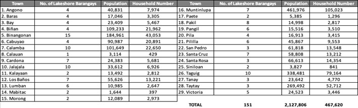
Source: Population and Household Number, Philippine Statistics Authority (PSA), 2020 Census of Population and Housing (2020 CPH)
Utilizing remote sensing data and geodata obtained from several sources, including the LLDA and the provincial government of Laguna, as well as both published and unpublished material, rapid assessment of the Laguna de Bay was conducted. Following are the significant findings:
i. Environmental
The assessment of the lakeshore, or the entire lake, highlighted the importance of understanding Laguna de Bay’s value in relation to resource utilization, livelihood protection, and climate change mitigation. Laguna de Bay retains its classification as a Class C freshwater body according to the criteria set by the Department of Environment and Natural Resources (DENR). Water hyacinth proliferation, algae blooms, and silt from the Pasig River prevent the waters from being clean. Furthermore, the growth of people along the lakeshore, the process of urbanization, and the development of industries pose a significant threat to the lake’s ecological balance. Soil erosion, chemical industry effluents, and domestic emissions contribute to the decline of the lake’s water quality.
Since Republic Act 9275 (An Act Providing for a Comprehensive Water Quality Management and for Other Purposes) of 2004 became law, which mandates that water quality management systems equipment must be present, including but not limited to industrial wastewater treatment collection and treatment facilities, there are still a small number of private and business sectors, particularly manufacturing and processing plants, that have implemented this requirement. In addition, none of the eight (8) main tributaries identified have implemented any water treatment measures to guarantee the cleanliness and absence of contamination in the water flowing into the lake, which is crucial for the lake’s restoration.
The ‘Laguna de Bay Basin Master Plan: 2016 and Beyond’ emphasizes the pressing issues of growing urbanization, industrialization, and population growth in the lake’s vicinity. These difficulties pose threats to the long-term environmental and economic viability of the area. The main strategies involve making the area resilient to climate change, securing funding through collaborations between the public and commercial sectors, and maximizing the economic opportunities offered by the lake.
The 2022 Laguna de Bay Basin study indicates that the sustainable management and maintenance of lake ecosystem services, including water, fish, rice, and climate regulation, are necessary. The decrease in fishery productivity indicates that the lake’s ecological status is under significant stress. EMB’s Sustainable Laguna Lake Management (2016) states that Laguna de Bay is an essential ecosystem that encompasses not only Metro Manila but also other susceptible provinces and municipalities.
The lakeshore barangays of Laguna Lake are susceptible to flood hazards due to their geographical location. The annual maximum level of Laguna de Bay is 12.5 meters, which is considered essential. At a level beyond this, there will be prolonged flooding along the lakeshore for several months. The lake’s floodwaters are sourced from the Marikina River, the Sierra Madre Mountain range, and the highland regions of Rizal and Laguna provinces (Lulu, 2023). The proposals for dredging Laguna de Bay seek to excavate the lake bed, resulting in a greater depth and increased capacity of the lake. This would be beneficial during periods of heavy rainfall, as it would help prevent overflow from tributaries such as the Marikina and Pasig Rivers (Cinco et al., 2013).
ii. Economic
Laguna de Bay plays a crucial role in the economic life of the communities along its shoreline. The importance of Laguna de Bay to the country’s economy led to the creation of a law (Republic Act No. 4850), which established the Laguna Lake Development Authority (LLDA) to draft comprehensive plans for optimal resource utilization and economic development within the area, including Laguna de Bay.
Laguna de Bay contributes significantly to the economy through various sectors, particularly aquaculture. Key economic contributions include:
- Fish Production: The lake is a major source of fish production in the Philippines, with fish pen and fish cage culture significantly contributing to the country’s fish supply (Israel, 2008).
- Income Generation: The aquaculture industry generates substantial income for fish pen and fish cage operators and those involved in related activities such as fish processing and marketing (Israel, 2008).
- Employment: The industry provides employment opportunities for many residents in the lake’s surrounding municipalities, including direct employment in fish farming and indirect employment in ancillary services (Israel, 2008).
- Public Revenues: The industry contributes to public revenues through taxes and fees collected from fish farming operations, supporting local government units and funding public services and infrastructure projects (Israel, 2008).
- Food Supply: The lake helps supply cheaper fish to Metro Manila, benefiting a large segment of the urban poor population and contributing to food security and affordability (ADB, 2023).
- Economic Growth: Economic activities associated with Laguna de Bay contribute to the overall economic growth of the region. Improved infrastructure and connectivity, such as the Laguna Lakeshore Road Network Project, further enhance economic opportunities and development (ADB, 2023).
iii. Social
The social aspect of Laguna de Bay’s lakefront is of utmost importance in relation to both economic and environmental matters. It provides several social contributions to the surrounding communities and the broader region. Key contributions include:
- Employment and Livelihood: The fish pen and fish cage culture industry provides employment and livelihood to many residents in the lake’s surrounding municipalities, supporting both direct and indirect employment (Israel, 2008).
- Food Security: The lake helps supply cheaper fish to Metro Manila, benefiting a large segment of the urban poor population and contributing to food security and affordability (ADB, 2023).
- Recreational Opportunities: Laguna de Bay offers recreational opportunities such as boating, fishing, and eco-tourism, which enhance the quality of life for local communities (Living Lakes Network, n.d.).
- Community Well-being: Eco-parks and natural areas around the lake serve as hubs for social interaction, fostering social ties and enhancing physical and mental health. These areas also provide a refuge for wildlife and a source of pride for the community (Guerrero III, 1996).
- Education and Awareness: The presence of natural areas and eco-parks offers educational opportunities for schools and communities to learn about biodiversity, conservation, and sustainable practices (Living Lakes Network, n.d.).
Furthermore, the presence of participatory governance systems strengthens social capital within the Laguna de Bay basin, fostering collaboration, inclusivity, and active community engagement. Involving local stakeholders in decision-making processes and ensuring equitable and just development are critical components of a sustainable shoreline management plan. Currently, Laguna de Bay benefits from an interactive governance framework that promotes stakeholder participation. A key example is the Yaman ng Lawa Initiative, which plays a vital role in empowering local communities to take part in the sustainable management and responsible utilization of the lake and its surrounding watersheds. This initiative not only enhances environmental stewardship but also reinforces the shared responsibility of protecting Laguna de Bay.
iv. Land Use/Land Cover Change in Laguna de Bay
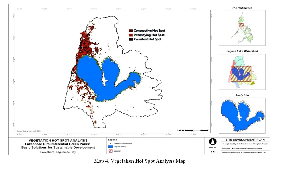
Monitoring land use and land cover is an important aspect of managing the Laguna de Bay watershed because it directly affects the lake’s water quality. Medina, J.M., et al. (2020) study reveals a clear correlation between the rise in urban development and the decline in water and wetland regions. The study suggests that the expansion of residential subdivisions near the lakefront and land reclamation activities are the main factors contributing to these impacts. The study reveals a link between the decline in overall vegetation coverage between 2001 and 2017 and the transformation of land into developed areas. The proportion of vegetated areas in recognized hot zones declined from 41% in 2001 to 19% in 2017. As shown in Map 4, vegetation hot spot areas cover 12.36% of the watershed. Of these vegetation hot spots, 39.55% are intensifying, 25.63% are persistent, and 20.70% are consecutive hot spots. The majority of the identified vegetation hot spots, particularly the intensifying and persistent ones, are on the northwest side of the watershed, which is the high-density urban area of Metro Manila. In Laguna’s southwest, concurrent vegetation hot spots dominate the low-density urban towns. Vegetation hot spots also occur along shoreline areas and rural town centers, where clusters of built-up structures are present. These environments are characterized by sparse vegetation.
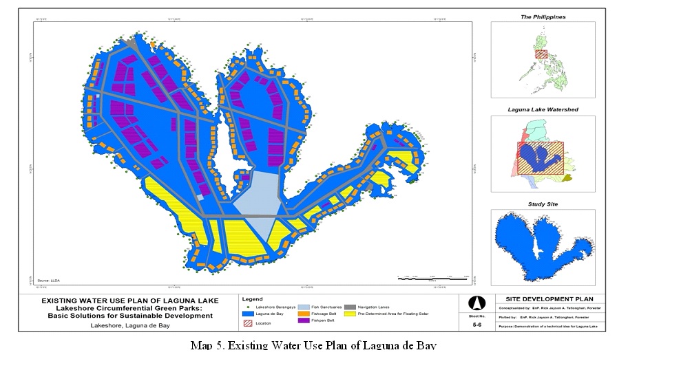
The current land and water use plan for the Laguna de Bay Basin is primarily based on land suitability analysis. An assessment was conducted to determine the suitability of the lake basin in terms of slope, soil, and elevation. Approximately 70,065 hectares, which is equivalent to one-third of the total land area of the basin, are ideal for urban development. These areas are predominantly located in the northwestern and southeastern parts of the basin. Map 5 shows the key focus areas for the LLDA, including protection and conservation, restoration, and lake-sensitive development, which is the main objective of the LLDA’s mission. The LLDA’s master plan prioritizes rehabilitation and protection, with its development efforts principally aimed at promoting lake sensitivity and providing support for rehabilitation, protection, and conservation. The master plan mandated the establishment of the required easement but did not specify its intended use. The document stated that any innovative ideas or strategies that could address emerging challenges would be considered for implementation.
Iizuka et al. (2017) focused their study on modeling and mapping the future land use and land cover (LULC) of the area surrounding Laguna de Bay. The study used data from 2015 (beginning), 2023 (middle), and 2030 (end) to analyze the changes that occurred in the LULC of the region. The modeling results revealed distinct trends of change in different LULC classes within the Laguna de Bay region. Urban areas are expanding further south and on the western side of Laguna de Bay, indicating a significant change in the built-up classes. This phenomenon has previously manifested. An examination of Google Earth images from the 1980s reveals clear indications of rapid LULC transformation in Metro Manila’s southern area and Laguna de Bay’s western side. The urbanized regions have grown in size in the southwestern portion of the study area, adjacent to a smaller lake. Additionally, there is evident urban expansion along the road networks on the eastern side of this lake. On the eastern side of the Laguna de Bay, there have been fewer changes in LULC compared to the western side. This is because the eastern side of the lake is predominantly rural, with a low population density and less infrastructure; therefore, rapid development does not impact it.
In summary, the Laguna Lake watershed is under significant urban development, with a correlation between urban growth and a decline in water and wetland regions. The expansion of residential subdivisions near the lakefront and land reclamation activities are the main factors contributing to these impacts. Vegetation hot spots, particularly intense and persistent ones, are predominantly on the northwest side of the watershed, dominated by high-density urban areas in Metro Manila.
B. Proposed Lakeshore Circumferential Green Parks
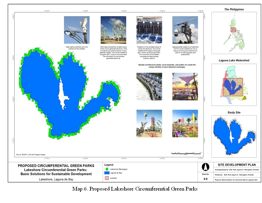
The proposed Lakeshore Circumferential Green Parks is envisioned to have access to common outdoor amenities and green spaces in every barangay that surrounds the lake. These areas are characterized by dynamic street life, green technology, and a unique cultural buzz. The goal is not only to rehabilitate or restore the lake but also to create a unique and distinctive identity for each place through the use of local materials, architectural styles, and public art (Map 6). This approach would foster a sense of community ownership and pride, encouraging residents to actively participate in the preservation and enhancement of their environment. By integrating sustainable practices and promoting local culture, these spaces would become vibrant hubs for recreation, social interaction, and environmental education. Such initiatives would not only improve the ecological health of the lake but also serve as a model for other communities seeking to balance development with conservation. As residents engage in these kinds of initiatives, they would cultivate a deeper connection to their surroundings, ensuring that the area’s natural beauty and cultural heritage are respected and celebrated for generations to come.
The lakeshore barangays in Laguna de Bay, particularly those in the western part of the lake, are ideally situated to enjoy the best green spaces and the stunning view of the freshwater lake. Barangay Lakeshore Circumferential Green Parks not only establishes a barangay or municipal circumferential green park within the lakeshore barangays of Laguna de Bay but also forges strong linkages within each barangay along the lakefront using the easement required by law.
The lakeshore barangay circumferential green parks will encourage people to walk, cycle, and use public transport (e-vehicles), as well as conserve and protect the second largest lake in Southeast Asia. The design should preserve and enhance green spaces to create a sustainable environment. This means using resources efficiently, reducing waste, increasing public awareness, and promoting renewable energy. Every lakeshore barangay green park will have its own rechargeable station made up of energy harvested from waves, winds, and the sun.
The proposed parks will create a vibrant, pedestrian-friendly, and green environment. This design, which surrounds urbanized towns, aims to provide access to green and open spaces for every lakeshore barangay.
The experience of pedestrians, cyclists, and e-vehicle users will be paramount to the design of a circumferential road, with street alignments calibrated for interesting views and lakescapes.
The master plan will incorporate the proportioning of space between Lakeshore Circumferential Green Parks and the interconnection of these areas through structure limitations, setbacks, and public rights of way. Design guidelines will promote the conscientious detailing of lakeshore circumferential green park facades, encouraging a high-quality public realm through attention to materiality, comfort, sociability, safety, and sustainability.
i. Green Connectivity
The proposed design will use green energy and structures as essential components to address sustainability concerns. Implementing circumferential e-vehicle paths will reduce traffic congestion, decrease pollution, and bring job opportunities closer to local inhabitants. This will boost Laguna de Bay’s appeal as a desirable employment hub. A broader demographic of commuters will be able to utilize the circumferential route, and the city will synchronize the transit hub to standardize the process of transferring between different modes of transportation. The design aims to enhance connectivity with buses, streetcars, bikes, and pedestrian networks, extending the advantages of street life and walking to a broader region, rather than confining all interactions to a single facility.
Each barangay will be equipped with recharge stations that utilize renewable energy derived from solar, wind, or wave-generated sources. Green connectivity will also include flexible, weather-resistant architecture and materials.
ii. Green Spirit and Identity
An essential element in the design and development process would be the establishment of a genius loci, which refers to the formation of a distinct spirit and identity for all lakeshore barangays of Laguna de Bay. This is crucial for ensuring long-term sustainability. The seriousness, magnitude, and visibility of this project will transform the perception of Laguna de Bay from a negative environment to a thriving hub of indigenous culture, aquaculture products, and ecological responsibility. The public space, which is responsive and welcoming, aims to amplify the feeling of pride in all lakeshore barangays. The concept of sense of place refers to the feelings and encounters associated with a specific geographical location. The place could serve as a microcosm that encapsulates the lakeside’s fundamental nature.
More crucial than the emergence of this new image will be the inherent connection to the local environment and the enhanced standard of living that it can provide. The concept will meticulously consider the experiential aspects of space, focusing on the genuine sensation of being present, to make every lakeshore barangay a cherished neighborhood within the Laguna Lake area.
The concept bears a strong resemblance to forestry, with a focus on highlighting the interconnections of nature. This pertains to the extent to which individuals incorporate nature into their sense of self. It involves a comprehensive comprehension of nature and all its constituents, including even the less attractive facets. The design endeavors to instill in each individual a profound concern for the environment. After experiencing the green revolution in the park, each person will cultivate a strong dedication to preserving the natural environment. Experiencing a sense of connection with nature fosters individuals’ concern for and commitment to its preservation.
iii. Integration of Sustainable Principles
The proposal has introduced a bold and far-reaching sustainability vision that the Laguna Lake Development Authority (LLDA) can integrate into its Master Plan’s sustainability strategy.
The Lakeshore Barangay Circumferential Green Park will establish a standard for sustainability and serve as a model for future development plans in LLDA and neighboring towns that can withstand the impacts of a changing climate. It aligns with the LLDA’s resilience plan and enhances the lakeshore barangay climate action strategy.
The Lakeshore Circumferential Green Parks sustainability strategy utilizes a structured system of themes, objectives, and criteria to clearly express and establish its vision. The proposed ambitious sustainability objectives and the distinct possibilities in the lakeshore barangays of Laguna Lake is evident in its use of six sustainability principles in site development. These principles were selected based on the project’s impact on and contribution to each of the six sustainability criteria.
The Laguna Lake Development Authority (LLDA) may transform the Lakeshore Circumferential Green Parks from a mere suggestion into an actual master plan, integrating it into the comprehensive land use plans (CLUP) of all the towns surrounding the picturesque Laguna de Bay. The seriousness, magnitude, and visibility of this project will transform the perception of Laguna de Bay, turning it from an unappealing environment into a thriving hub of indigenous culture, aquaculture products, and environmental sustainability. The public space, which is responsive and welcoming, aims to improve the feeling of satisfaction in all lakeshore barangays. The concept of sense of place refers to the feelings and encounters associated with a specific geographical location. A location could represent a microcosm that captures the essence of a lakeshore.
Even more significant than this new image will be the local sense of place and the enhanced quality of life Laguna de Bay’s lakefront will bring. Lakeshore Circumferential Green Parks will prioritize the experiential aspects of space, ensuring that the feeling of being there is carefully considered. This will contribute to Laguna de Bay Shores being a well-regarded area in the country.
The proposed initiative has identified six of the eight sustainability principles, listed in no particular order:
1. Site Selection (access to nature) – As stated earlier, developing a sense of connection with nature enhances individuals’ awareness of and dedication to its conservation. The establishment of Circumferential Green Park aims to mitigate the degradation of natural ecosystems in Laguna de Bay, counteract biodiversity loss, and safeguard endangered species from lake extinction. Furthermore, the park will provide access to lake resources and markets for small-scale artisanal fishermen while also improving lake conservation and sustainable use.
2. Energy Efficiency (aiming for carbon neutrality) – Circumferential Green Parks aims to optimize energy performance, reduce energy consumption, and ensure universal access to affordable, reliable, sustainable, and innovative energy for all. An area dedicated to recharging electric vehicles will be provided free of charge, and the electricity utilized in this area will be generated solely from renewable sources such as waves, wind, and solar power. The following will be installed in the green park:
- Floaters turn the constant power of waves into electricity. This will be installed at the edge of the green park, where waves are abundant. The movement of the floaters compresses and decompresses hydraulic pistons.
- Wind trees harness the constant power of the wind to generate electricity while simultaneously enhancing their unique aesthetic appeal. This will be installed in the green park, where wind is abundant. The movement of wind turbines generates electricity.
- Solar lights combined with wind turbines will be installed.
- Solar-powered closed-circuit television (CCTV) will be installed not only to ensure continuous surveillance but also for monitoring green park sustainability.
3. Green Infrastructure (green park) – Circumferential Green Parks will encourage the use of environmentally friendly materials, such as green roofs, and other ways to enhance biodiversity and improve air quality in the area.
4. Design for climate resilience (climate resilience park) – Circumferential Green Parks will make a modest contribution to the efforts to combat climate change and mitigate its impact on the lakefront community. The green park surrounding the lake will function as a flood control measure, enhancing the lake’s ability to withstand and adapt to climate-related hazards and natural calamities.
5. Community engagement (circular network of partnership) – The primary emphasis of Circumferential Green Parks is on promoting both well-being and social value. All lakeshore barangays, who are stakeholders, will be involved in the site planning process, along with the local community, to ensure their involvement and promote social fairness and inclusivity.
6. Connectivity and walkability (loop of connectivity and walkability) – The project, named Lakeshore Circumferential Green Parks, aims to enhance pedestrian- and bicycle-friendly infrastructure, facilitate connectivity to public transportation, and provide access to facilities. These efforts are intended to decrease dependence on private vehicles and enhance public health.
C. Evaluation and Justification
The proposed Lakeshore Circumferential Green Parks is a feasible and practical solution, aligned with the Laguna de Bay Master Plan and crucial for the lake’s restoration, rehabilitation, and sustainable development. Beyond benefiting the surrounding towns, its green impact is expected to resonate across the country, offering significant environmental, social, and economic contributions.
Local funding for the project can be sourced from either barangay or municipal funds, with the Laguna Lake Development Authority (LLDA) Master Plan readily available for adoption by local government units (LGUs) in their Comprehensive Land Use Plans (CLUP). Additionally, the Department of Budget and Management (DBM) can allocate funding through the Local Government Support Fund—Support to the Barangay Development Program (LGSF-SBDP). Public-private partnerships (PPPs) also present an excellent avenue for further financial support, enabling the realization of this transformative project.
The Lakeshore Barangay Circumferential Green Park offers a practical, foundational solution to the longstanding issue of Laguna Lake’s restoration. Beyond the ecological benefits, engaging local communities in the rehabilitation process fosters greater public awareness about the importance of Laguna Lake. Studies show that awareness at specific sites or areas significantly aids in the restoration of environmentally degraded regions. A sense of connection to nature sparks individuals’ commitment to its preservation—particularly among barangay officials who are diligent in project execution, cleanup efforts, and monitoring tasks. These officials often lead community-driven initiatives like the weekly “Atag” cleanup, demonstrating their strong sense of accountability towards environmental conservation.
Moreover, given that all bodies of water in the Philippines are state-owned and governed by legal easement laws the proposal is not only practical but also legally sound. The sole challenge to the implementation of this suggested circumferential green park is the execution of Article 51 of PD 1067, also known as the Water Code of the Philippines, which states that the banks of rivers and streams, as well as the shores of seas and lakes, are subject to public easement for recreation, navigation, floatage, fishing, and salvage. These zones are defined as three meters in urban areas, twenty meters in agricultural areas, and forty meters in forest areas. The public is allowed to use these zones for recreation, navigation, floatage, fishing, and salvage, but no one is permitted to stay longer than necessary or to construct structures within these zones. However, after 58 years of the establishment of the Laguna Lake Development Authority (LLDA) in 1966, the resorts and houses in the easement area remain intact, and some are growing by reclaiming land.
With strong political will, combined with advanced technologies and innovative solutions, the successful implementation of this initiative is highly feasible. Enhancing lake monitoring through the installation of green energy-powered CCTV cameras will significantly improve cost efficiency and surveillance effectiveness. These cameras, powered by renewable energy sources, can be monitored in real time from barangay halls, nearby LLDA offices, or local police stations, streamlining security operations and enabling swift response measures.
Integrating sustainable energy solutions—such as solar, wind, and wave energy—into the project offers substantial environmental benefits. Unlike fossil fuels, these renewable sources reduce carbon emissions, promote energy independence, and actively contribute to ecological restoration. Moreover, incorporating green technologies within the park reinforces a commitment to sustainability, setting a precedent for other regions to adopt similar eco-friendly initiatives. This approach not only strengthens environmental resilience but also demonstrates a forward-thinking model for responsible urban and ecological planning.
CONCLUSION AND RECOMMENDATIONS
By employing simple geospatial techniques in rapid assessments and urban planning, this study effectively evaluated the current condition of Laguna de Bay and proposed the development of Lakeshore Circumferential Green Parks along the shoreland areas of the lake. This design represents a practical, implementable solution in alignment with the designated legal easement for Laguna Lake. The Green Park will serve as an educational tool, raising awareness about the benefits of green infrastructure and providing a balanced approach to development and environmental conservation for sustainable lakeshore management. People living near the lake—and those who experience its beauty—are more likely to feel a deep commitment to its protection and preservation. A connection to nature fosters a sense of responsibility and dedication to conservation efforts.
The proposed green park will function as a habitat for a variety of plant and animal species, thereby enhancing local biodiversity. Additionally, it will improve air quality by absorbing pollutants, increasing oxygen levels, and mitigating the urban heat island effect. Vegetation will contribute to climate change mitigation by sequestering carbon dioxide and reducing the release of greenhouse gases. Beyond its role in flood control, the permeable surfaces and plant life will help absorb excess precipitation, reducing the risk of flooding in surrounding areas.
In terms of social and health benefits, the Lakeshore Circumferential Green Parks will provide essential spaces for recreation, physical activity, and relaxation, promoting both physical and mental well-being. The park will also foster social interactions, community gatherings, and cultural events. Exposure to nature has been shown to reduce stress and improve mental health, contributing to the overall well-being of residents and visitors.
Economically, the park will deliver a range of advantages. Green spaces are known to increase property values, attracting investment and enhancing the appeal of the surrounding area. Well-planned parks have the potential to draw tourists, generating income and further stimulating local businesses. Furthermore, the park will create numerous employment opportunities in maintenance, landscaping, and other services, providing economic benefits to the community.
Given the constraints of time and study, the following recommendations were suggested for future research and analysis to improve the proposed lakeshore circumferential green parks:
a. Ecological Studies:
- Perform biodiversity assessments to comprehend the current flora and fauna in the designated shoreline barangay circumferential green park area.
- Conduct a thorough examination of the possible influence of the park on nearby ecosystems, specifically focusing on wetlands, bird habitats, and aquatic organisms.
b. Hydrological and Soil Studies:
- Conduct analysis of soil composition, drainage patterns, and groundwater levels to provide information for park design.
- Evaluate the potential for flooding and create plans for environmentally friendly stormwater control.
c. Social and Community Research:
- Administer surveys and facilitate focus groups to get insights into the desires, requirements, and anticipations of the community about facilities for the shoreline barangay circumferential green park.
- Investigate strategies to foster community involvement and encourage a sense of responsibility towards the park.
d. Economic and Financial Analysis:
- Assess the expenses associated with park development, maintenance, and operation.
- Analyze prospective sources of income (such as admission fees and concessions) and economic advantages (such as increased property value and tourism).
e. Physical and Mental Health Research:
- Examine the influence of green spaces on the physical and mental well-being of residents.
- Evaluate the lakefront barangay circumferential green park’s capacity to promote physical activity and enhance overall health.
f. Urban Design and Accessibility:
- Investigate avant-garde design elements (such as green roofs and vertical gardens) that augment sustainability.
- Examine the accessibility needs of all residents, encompassing those with impairments, elderly individuals, pet enthusiasts, and toddlers.
g. Long-Term Monitoring and Evaluation:
- Establish monitoring initiatives to evaluate ecological shifts, tourist utilization, and park effectiveness over an extended period.
- Consistently assess the performance of the lakeshore barangay circumferential green park in attaining sustainability objectives.
Effective lakeshore barangay circumferential green park development and long-term impact necessitate interdisciplinary collaboration among urban planners, ecologists, social scientists, and community members.
REFERENCES
- Asian Development Bank. (2023). Laguna Lakeshore Road Network Project: Initial Poverty and Social Analysis. Retrieved from ADB.
- Advanced Water Technologies [Natural Lake & Pond Treatment]. (2018 January 11). [Video]. YouTube. https://www.youtube.com/watch?v=kMLc73tK8vk
- A walk in the park: The need for urban green spaces. (2025 January 26). Manila Bulletin. https://mb.com.ph/2025/1/26/a-walk-in-the-park-the-need-for-urban-green-spaces
- Babu, Raghu N. (2000). Environmental Planning: The Needs and The Possibilities… GIS Development. September, 4(9).
- Batty, M. (2005). Cities and Complexity: Understanding Cities with Cellular Automata, Agent-Based Models, and Fractals. MIT Press.
- Burrough, P. A., & McDonnell, R. A. (1998). Principles of Geographical Information Systems. Oxford University Press.
- Laguna de Bay | lake, Philippines. (2025). Encyclopedia Britannica. https://www.britannica.com/place/Laguna-de-Bay
- Campbell, J. B., & Wynne, R. H. (2011). Introduction to Remote Sensing. Guilford Press.
- Cinco, Maricar P., Ponte, Romulo O., Mallari Jr., Delfin T. (2013 August 20). Laguna lakeshore flooding feared. Inquirer Southern Luzon. https://newsinfo.inquirer.net/470443/laguna-lakeshore-flooding-feared#ixzz8fNYiVE2G
- Clarke, K. C. (2003). Getting Started with Geographic Information Systems. Prentice Hall.
- DHSUD Codifies Requirements, Procedures in Housing Sector, 2024 (Ph), Department Circular (DC) 2024-005, Department of Human Settlements and Urban Development (DHSUD). https://manilastandard.net/home-design/314424177/dhsud-codifies-requirements-procedures-in-housing-sector.html
- FACTS. (2024, June 21). 14 Fascinating Facts About Laguna De Bay. https://facts.net/nature/universe/14-fascinating-facts-about-laguna-de-bay/#:~:text=Key%20Takeaways%3A%201%20Laguna%20de%20Bay%20is%20a,and%20offers%20stunning%20sunrise%20and%20sunset%20views.%20
- Gibbens, Sarah. (2019, May 21). How parks help cities adapt to climate change. Environment. https://www.nationalgeographic.com/environment/article/climate-crisis-cities-turn-to-parks
- Green, Green, Green pushes city governments to build better open spaces, 2018 (Ph), Department of Budget and Management (DBM). https://www.dbm.gov.ph/index.php/management-2/758-green-green-green-pushes-city-governments-to-build-better-open-spaces
- Guerrero III, R. D. (1996). Human impacts on Laguna de Bay, Philippines and management strategies for their mitigation. Geo Journal, 40(1-2), 69-72.
- Guidelines on the Establishment of Legal Easements Along the Seas, Rivers, Lakes, Esteros, and Creeks, 2021 (Ph), DAO 2021-07, Department of Environment and Natural Resources (DENR). https://apidb.denr.gov.ph/infores/uploads/DAO-2021-07.pdf
- Henry, Robert S. ed. 1959. ATLAS of the Philippines. Phil-Asian Pub., Inc.
- Israel, D. C. (2008). Fishpen and Fishcage Culture in Laguna de Bay: Status, Economic Importance, and the Relative Severity of Problems Affecting its Practice. Philippine Institute for Development Studies.
- Laguna Lake Development Authority. (2024, June 21). Laguna de Bay. https://llda.gov.ph/laguna-de-bay/
- Iizuka, Kotaro et al. 2017. Modeling Future Urban Sprawl and Landscape Change in the Laguna de Bay Area, Philippines. Land 2017, 6(2), 26. https://doi.org/10.3390/land6020026
- Laguna Lake Development Authority. (2016). Laguna de Bay Basin Master Plan: 2016 and Beyond (Towards Climate-Resilience and Sustainable Development). https://llda.gov.ph/wp-content/uploads/dox/ldbMP2016.pdf
- Lakepedia. (2024, June 21). Laguna De Bay: The Largest Lake in the Philippines. https://www.lakepedia.com/lake/laguna-de-bay.html#:~:text=A%20total%20of%2012%20cities%2C%2049%20municipalities%20and,lake%20with%20a%20population%20of%20over%206%20million
- Lasco, R. D., & Javier, E. Q. (2017). Laguna De Bay: A Case Study for Sustainable Fisheries Development. https://transactions.nast.ph/wp-content/uploads/2021/12/2017 Plenary Paper Lasco RD 2.pdf
- Living Lakes Network. (n.d.). Laguna de Bay – Living Lakes Network. Retrieved from Living Lakes Network
- Lulu, Gabriel Pabico. (2023, March 16). Solon wants Laguna Lake dredging project revisited: It will help flood control efforts. The Inquirer. https://newsinfo.inquirer.net/1744031/solon-wants-laguna-lake-dredging-project-revisited-it-will-help-flood-control-efforts
- Maidment, D. R. (2002). Handbook of Hydrology. McGraw-Hill Education.
- Mather, P. M., & Koch, M. (2011). Computer Processing of Remotely-Sensed Images: An Introduction. Wiley.
- Mazaa, Patricia Ikouta. (2021). Concepts of Sustainable Development; a Literature Review and a Systematic Framework for Connecting the Role of Education with the Sustainable Development Goals. International Journal of Humanities Social Sciences and Education (IJHSSE), 8(8), 106-112. https://www.arcjournals.org/pdfs/ijhsse/v8-i8/9.pdf
- McCosh, C. (2024, January 16). Dollars and Sense: Economic Benefits of Community Green Spaces. Trust for Public Land. https://www.tpl.org/blog/dollars-and-sense-economic-benefits-of-community-green-spaces
- Medina, J.M. et al. (2020). Land Cover Monitoring of Laguna Lake Watershed Using Modis NDVI Data. The International Archives of the Photogrammetry, Remote Sensing and Spatial Information Sciences, Volume 42(3)/11. https://edcintl.cr.usgs.gov/downloads/sciweb1/shared/co/nli pecora/pecora 21/manuscript proceedings/Land Cover % 29 Monitoring of Laguna Lake Watershed.v1.pdf
- Mensah, J., & Ricart Casadevall, S. (2019). Sustainable development: Meaning, history, principles, pillars, and implications for human action: Literature review. Cogent Social Sciences, 5(1). https://doi.org/10.1080/23311886.2019.1653531
- National Academies of Sciences, Engineering, and Medicine. 1992. Restoration of Aquatic Ecosystems: Science, Technology, and Public Policy. Washington, DC: The National Academies Press. https://doi.org/10.17226/1807.
- Philippine Statistics Authority (PSA), 2020 Census of Population and Housing (2020 CPH), which states that the population of the Philippines as of May 1, 2020 is 109,035,343.
- Poikane, Sandra et al. (2024). A global assessment of lake restoration in practice: New insights and future perspectives. Elsevier. Ecological Indicators 158. https://www.sciencedirect.com/science/article/pii/S1470160X23014723
- Republic of the Philippines. (1976). Presidential Decree No. 1067: The Water Code of the Philippines. Retrieved from Official Gazette.
- Rudd, Alan [News from the Ground Up: Producers Cooperative Association]. (2019 June 14). Clearing Up Muddy Lakes and Ponds [Video]. YouTube. https://www.youtube.com/watch?v=nQ-wAv6Eykw
- Rudrawar, Shireeshkumar. (2020). Use of GIS in Sustainable Urban Planning: A review. 105-111.
- Saloma, C., & Akpedonu, E. (2021). Parks, plans, and human needs: Metro Manila’s unrealised urban plans and accidental public green spaces. International Journal of Urban Sustainable Development, 13(3), 715–727. https://doi.org/10.1080/19463138.2021.2021418
- Schottland, T. (2019, April 5). Parks as a Solution to Climate Change | Health & Wellness | Parks and Recreation Magazine | NRPA. Www.nrpa.org. https://www.nrpa.org/parks-recreation-magazine/2019/april/parks-as-a-solution-to-climate-change/
- Sieber, R. E. (2006). Public Participation Geographic Information Systems: A Literature Review and Framework. Annals of the Association of American Geographers, 96(3), 491-507.
- Tammeorg, Olga, et al. (2024). Sustainable lake restoration: From challenges to solutions. WIREs Water, 11(2), e1689. https://doi.org/10.1002/wat2.1689
- Tatlonghari, Rick Jayson A. (2020). Concept Paper for Cavinti Green Economic Zone [Unpublished manuscript]. LGU Cavinti, Laguna.
- Tatlonghari, Rick Jayson A. (2002). Rapid Initial Criterion Key (RICK) Model for Selection of Suitable Disposal Site Using GIS Technology [Unpublished manuscript]. IRNR-CFNR, Graduate School, University of the Philippines Los Baños.
- Tatlonghari, Rick Jayson A. (2024). GIS & Remote Sensing Capacity Development for Coastal Monitoring in the Mekong Delta [PowerPoint slides].
- The Water Code of the Philippines, 1976 (Ph), PD 1076, https://lawphil.net/statutes/presdecs/pd1976/pd 10671976.html
- Tripathy, G.K. and P. Jothimani. (2000). Monitoring Water Pollution: Spatially! GIS Development. September, 4(9).
- United Nations. (2015). Take Action for the Sustainable Development Goals. https://www.un.org/sustainabledevelopment/sustainable-development-goals/
- van der Linden, S., Okujeni, A., Canters, F. et al. (2019). Imaging Spectroscopy of Urban Environments. Surv Geophys 40, 471–488. https://doi.org/10.1007/s10712-018-9486-y
- Vargas-Nguyen, Vanessa. (2015, July 21). Laguna de Bay, Philippines: Environmental Literacy. https://ian.umces.edu/blog/laguna-de-bay-philippines-environmental-literacy/
- What is an ecological park – definition and benefits. (2024). Green-Ecolog.com. https://green-ecolog.com/15339364-what-is-an-ecological-park
- Wellman, Thilo et al. (2020). Remote sensing in urban planning: Contributions towards ecologically sound policies? Elsevier. Landscape and Urban Planning 204. https://www.sciencedirect.com/science/article/pii/S0169204620308860
- Western Environmental Liner. (2024, June 26). Lake Restoration – What, Why and How. https://westernliner.com/blog/lake-restoration-what-why-and-how/
FOOTNOTES
[1] A large-scale map typically has a smaller ratio, such as 1:1,000 or 1:5,000, and provides greater detailed information, like roadways and building footprints. A small-scale map, with a ratio of 1:500,000 or 1:1,000,000, depicts an entire state, province, or country, showing just the biggest cities or towns and key roadways (source: https://education.nationalgeographic.org/resource/map-scale/).
[2] Excerpt from Laguna de Bay Basin Master Plan: 2016 and Beyond (Towards Climate-Resilience and Sustainable Development).