
Geospatial Assessment of Potential Areas for Arthropod-Vectors of Rift Valley Fever Virus (RVFV) Across Nigeria Using Modis-Ndvi Dataset
- Sadiq Abdullahi Yelwa
- Salawu Onoruoiza Ganiyu
- Abubakar Umar
- 116-123
- Sep 21, 2024
- Public Health
Geospatial Assessment of Potential Areas for Arthropod-Vectors of Rift Valley Fever Virus (RVFV) Across Nigeria Using Modis-Ndvi Dataset
1Sadiq Abdullahi Yelwa, 2Salawu Onoruoiza Ganiyu and 2Abubakar Umar
1Department of Environmental and Resources Management, Usmanu Danfodiyo University, P.M.B 2346, Sokoto, Nigeria
2Department of Geography, Nigerian Defence Academy, P.M.B. 2109, Kaduna
DOI: https://doi.org/10.51244/IJRSI.2024.1115008P
Received: 19 August 2024; Revised: 29 August 2024; Accepted: 03 September 2024; Published: 21 September 2024
ABSTRACT
Rift Valley Fever Virus (RVFV) is an arthropod-borne viral disease that affects both domestic animals as well as human beings. The outbreaks of such disease especially in Africa are reported to be closely related to areas of above or below normal rainfall that is associated with the warm phase of El-Niňo Southern Oscillations (ENSO) phenomenon. This ENSO event is as a result of abnormal change in sea surface temperature that affects global precipitation and in other areas, vegetation biomass. For a sustainable healthy environment and healthy livestock production in Nigeria under the present economic circumstances, this study therefore, suggests a cost-effective technique for mapping out spatial patterns of likely RVFV and other vector-borne disease habitats across Nigeria. Remote Sensing and GIS can be a cost-effective component of disease control campaign for mapping out potential areas at risk of such diseases. Principal Component Analysis (PCA) technique was used where Standardised Principal Components images and their corresponding loading scores were derived from Normalised Difference Vegetation Index (MODIS-NDVI) dataset acquired from USGS-EROS Data Center for the ENSO event of September 2014 to December 2015 covering Nigeria and parts of surrounding countries. The results on the first principal component image showed a characteristic vegetation biomass pattern across Nigeria over the entire time-series. The second component shows a cyclic trend related to climatic variations and vegetation across the country. A threshold in the PCA was used to isolate and produce a potential risk areas map primarily considered to have potential of RVFV and other arthropod-borne disease across the country. For sustainable ecological environment and healthy livestock production in Nigeria the results derived from this study would provide public health authorities like epidemiological departments and other stakeholders with a working document for animal disease reporting system which would also cut down operational costs.
Keywords: Rift Valley Fever, Remote Sensing and GIS, MODIS-NDVI , potential risk areas, PCA
INTRODUCTION
Rift Valley Fever (RVFV) is an arthropod-borne viral disease that affects both domestic animals like sheep and cattle as well as human beings (Ikegami and Makino, 2011; Lagare et al; 2019). The name Rift Valley Fever originated from the name given to a location where the first epizootic of RVF was discovered in an isolated farm near Lake Naivasha in Kenya where a high mortality of sheep was reported by Daubney, et al; (1931) and also shown a generic evidence of rift valley fever outbreak (Carrol et al; 2011) in an area mainly dominated by Savanna grassland. Other studies such as Mcintosh and Jupp (1981; Logan et al; 1992) have also showed that the disease which occur periodically in much of the sub-Saharan Africa as a vector-borne disease is transmitted by a variety of mosquito species that affect both domestic animal as well as human beings. It was also reported that over 100 years this disease seems to be lethal particularly in livestock and therefore requires further approach (Bron et al; 2021). The transmission of such disease was shown to be linked to Global warming which is likely to affect the impacts associated with the warm phase of El Niňo Southern Oscillations (ENSO) phenomenon that used to cause abnormal changes in rainfall or even drought (Anyamba et al; 2001) as well as those that correlate with cases of diseases due to the changing climate (Kemi et al; 2024). Accordingly, because of the changing climatic conditions there is potential in the evolution of this viral disease (Ebogo-Belobo et al; 2023) and therefore, there is need for other methods of periodic monitoring and surveillance. The views by Yelwa, 2008; Yelwa and Dangulla (2013) are that changes in landuse in an extended ecological environments are likely to trigger local and in some areas national climatic changes which can boost the response patterns and mosquito-borne disease that can be threats to both human and animal health. In this regard therefore, Normalised Difference Vegetation Index (NDVI) time-series dataset can be used as a proxy measurements of ecological conditions to identify areas at risk for specific types of animal diseases such as RVF and trypanosomiasis (Green and Hay, 2002). From studies with NDVI data derived from Moderate Resolution Imaging Spectrometer (MODIS) therefore, it was shown that such data can be utilised in epidemiological studies to map out potential habitats of such disease vectors especially in Africa where the resources to deal with disease problems are not readily available (Neteler, 2005; John et al; 2008; Rhew et al; 2011). While studies by Tucker et al; (1985) and Linthicum et al; (1999) have shown that there is close relationship between seasonal development of green vegetation (NDVI) with breeding and upsurge patterns of insect vectors, particularly locust and mosquitoes, other studies linked to global climatic change related to ENSO events will endanger both animals and humans to contacting the RVF Virus (Sutherst, 1998; Patz et al; 2000 and Adesola and Idris, 2022). All these are most likely due to the witnessing of abnormal rainfall and fast vegetation development that provide habitats for animal vector-borne diseases Umar and Gray (2023). Other emerging environmental health issues in Nigeria are currently those related to climate changes (Pona et al; 2021) and which influence this infectious diseases with reported seroprevalence RVFV cases in five states in the northern part of Nigeria (Sokoto, Katsina, Kano, Kaduna and Borno) (Adesola and Idris (2022) and another serologic evidence of silent RVFV infection among occupationally exposed persons in northern Nigeria with warning of impending outbreaks (Oragwa et al; 2022). In view of this, there should be in place an integrated response and further approach to contain the situation (Bron et al; 2021, Nelson Wandera et al; 2023). The purpose of this paper therefore, is to map out likely spatial patterns of potential risk areas of this RVF vector-borne disease using MODIS-NDVI dataset acquired from the Moderate Resolution Imaging Spectrometer (MODIS) satellite to target such localities for sustainable healthy human and livestock environment across the whole country.
MATERIALS AND METHODS
The Study area covered the whole of Nigeria including substantial area of Cameroon in the East, parts of Lake Chad in the northeast, the southern Sudan Savanna area of Niger Republic and the entire Benin Republic in the West. The whole study area is bounded by Longitude 2º 00’ to 14º 00’ East and Latitude 4º 09’ and 14º 00’ North. This is a diverse area that comprised parts of the African Sahel, the Savanna and tropical rain forest.
For the purpose of this geospatial assessment, monthly dataset in the form of Normalised Difference Vegetation Index (NDVI) at 250 meters spatial resolution was acquired from National Aeronautics Space Administration (NASA)’s Moderate Resolution Imaging Spectrometer (MODIS) Climate Modelling Grid (CMD). The coordinates corresponding to the study area which covers the southern part of Niger republic and some part of Cameroon was windowed using version-18 raster-based (TerrSet) remote sensing software within a GIS environment. The ecosystem zone with inter-annual variability signal related to the ENSO phenomenon considered as potential areas of RVFV and other vector-borne disease outbreaks across Nigeria and surrounding countries were identified and sieve out spatially in three stages. This assessment doesn’t require blood samples from animals or humans infected with RVF virus for biological laboratory analysis but rather, NDVI dataset. Hence, the required NDVI dataset corresponding to the most recent strongest El Niño months of September 2014 to December 2015 (based on the United States Climate Prediction Center’s threshold of +/- 0.5oC for the Oceanic Niño Index (ONI)) were sieved out from the NOAA-MODIS dataset. Secondly, Principal Component Analysis (PCA) was applied to the monthly NDVI dataset in order to isolate and obtain the first three standardised principal components from the other component images and their corresponding loading scores. Thirdly, a supplementary method was used where a mean NDVI image of the time-series dataset was derived and a threshold applied to the image data so as to isolate and produce a map showing areas which most likely correspond to potential risk areas of RVFV and other habitats of vector-borne disease across the study area.
RESULTS AND DISCUSSION
In this geospatial assessment the MODIS-NDVI dataset utilised was subjected to PCA within a GIS environment using a t-mode forward process. Two main results emerged (standardised component images and loading scores) indicating the degree of correlations with the original NDVI dataset. In most cases, this type of process compresses a large dataset and ease the analysis in addition to providing avenue for reducing noise inherent in the dataset. As an experimental geospatial analysis in environmental health and epidemiology using satellite imageries and GIS across Nigeria, the results yielded sixteen (16) component images with their corresponding loading scores the discussion is limited to the first three (3) components images and their loading scores representing about 81% of the total variance in the total 16 monthly MODIS-NDVI dataset. One of the objectives of remote sensing and GIS in epidemiology is to map out distribution of a disease in our environment so that control efforts in endemic situations and intervention strategies in epidemic situations can be most effectively directed (Hay et al; 1997). Results derived from this study is presented in Table 1 indicating the percentage variance of three component images and Figures 1 and 2 showing two standardised principal component images and a map of NDVI climatology indicating potential risk areas of RVFV and other vector-borne diseases. Other information from the results is the loading graphs showing correlations between the NDVI time-series dataset utilised in the analysis and the component images. Since most RVFV and related disease outbreaks were reported in regions of complex savanna vegetation with persistent above average rainfall followed by prolonged dry season (Green and Hay, 2002; Neteler, 2005; Rhew et al; 2011), a historical vegetation biomass map of Nigeria as well as seasonal and inter-annual variability map is therefore essential in order to map out RVFV and related vector-borne disease risk areas. Furthermore, because this type of dataset was duly processed to avoid anomalies that can distort results on analysed satellite imageries (Hay et al; 1997, Didan, 2015), it has been used for both continental and regional scales in environmental studies (Santra and Chakraborty, 2011; Luxon and Pius, 2012; Xiao et al; 2016; Zhang et al; 2017; Prajesh et al; 2019, Abdullahi and Yelwa, 2020). Hence, this type of dataset can conveniently be used to carryout geospatial mapping of potential risk locations of this RVF Virus so that it can specifically be targeted and actions taken more effectively. However, there are other studies such as Anywaine et al; 2022 and Ebogo-Belobo, et al; 2023 that focused only on systematic review of laboratory confirmed cases rather than sampling and direct laboratory analysis.
The information in table 1. shows the loadings scores for components one to three which together explains about 81% of the total variance of the 16-months NDVI dataset utilised in this analysis. In Figure 1(a) showing the first standardised principal component image, it highlights historically, the typical representative vegetation biomass pattern across Nigeria and surrounding areas covering the monthly time-series (September 2014 to December 2015). The pattern on the first component image shows correlation between the component image and the whole NDVI dataset used in the analysis. Areas that are less correlated with the NDVI dataset and the component image are located in the northern Savanna mostly in brown and yellow indicating less vegetation vigour (ie. when viewed using an NDVI colour pallete). On the other hand, areas with high positive correlations between the dataset and the component image are located in the central part of the country, particularly in Kaduna, Niger, Federal Capital Territory (FCT) and Nassarawa states, the southern forest zone and southern part of Cameroon as well as some locations around Lake Chad. These areas can be seen in green to dark green colour indicating more vegetation vigour. In Figure 1(b) indicating the second component image, this shows about 14% of the total variance in the whole dataset. As one of the change component, it is an indication of negative correlations (negative vegetation anomaly pattern) across the whole of the northern part of the country, whole of the southern part of Niger republic and almost the whole of Cameroon but with a fairly positive anomaly around the Kainji lake and along rivers Niger and Benue in the northern part of the country. On the other hand, this component image shows positive anomaly pattern across ten states in the southern part of the country namely, Abia, Akwa-Ibom, Bayelsa, Cross-river, Delta, Edo, Imo, Ondo, Osun and Rivers as well as the southern part of Cameroon which is an indication of the rainfall pattern in these states during 2014 to 2015 ENSO phase. In Figure 1(c) indicating the third component image, this shows just 4% of the total variance in the whole dataset which by implication points to the fact that almost the entire country is correlated negatively with the whole NDVI dataset utilised in the analysis. Furthermore, the trend on the graphs of the loading scores in Figure 1(d) for the three component images show that Component three image indicates a positive peak in the loading scores which is slightly over 0.4 in August 2015 (coinciding with a lower peak of the component one loading graph). This is the image that has a negative correlation during the whole series across the study area (Figure 1c) except in Borno state. Accordingly, this can be indicative of the effects of environmental changes on the emerging parasitic diseases like RVFV (Patz et al; 2000). Component two loading score shows the lowest negative peak (̴ -0.7) on the graph in the month of August, 2015. This result corresponds to the rainfall pattern during the ENSO event of 2014 to 2015 between the northern and southern part of Nigeria. While August is the peak rainy season in the northern part of the country, it can be seen in Figure 1(b) that most of the northern part of the country shows negative correlations with the dataset. On the other hand, Figure 1(d) is clearly indicating that the area was experiencing very low rainfall due to the low peak in August 2015 for component two. Thus, impact on vegetation NDVI by this ENSO event across Nigeria in the time-series is also shown in another lower peak of the graph of the loading scores of Component one image (Figure 1d) where most of the study area should have an average vegetation cover. By implication, this corresponds to the view of Adeyeye et al; (2011) that environmental health situation is usually an interconnection between human activities and the environment.
Table 1. Percentage Variance of Three Component Images
| Component Percentage Variance
Image (%) with total dataset |
| Comp 1 62.79642
Comp 2 13.97606 Comp 3 4.12597 |
| Total Variance = 80.89845 % |
(Source: PCA Analysis)
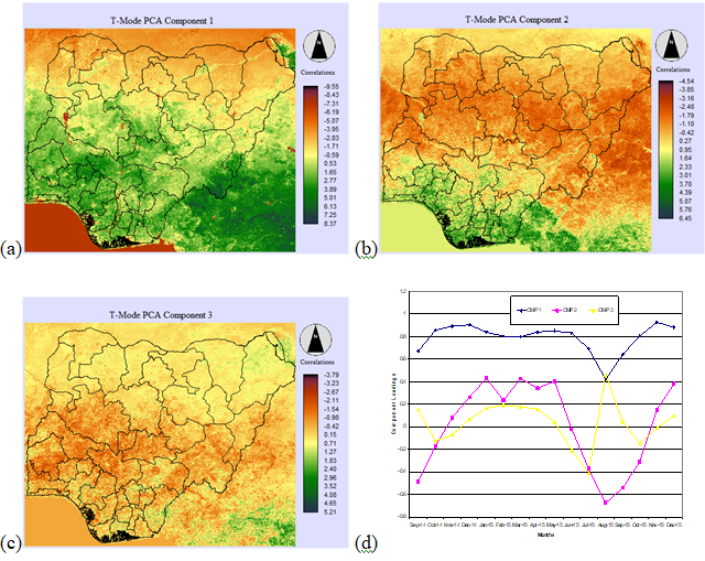
Figure 1. Standardised Principal Component images and Loading Scores.
(a) the first component image that shows typical characteristic of the average amount of vegetation biomass across Nigeria and neighbouring countries (b) the second component image shows a seasonal cycle of vegetation of the time series (c) the third component image shows a semi cycle trend of the vegetation, while (d) shows the loading scores of the 16-months NDVI dataset for components one to three derived from PCA analysis.
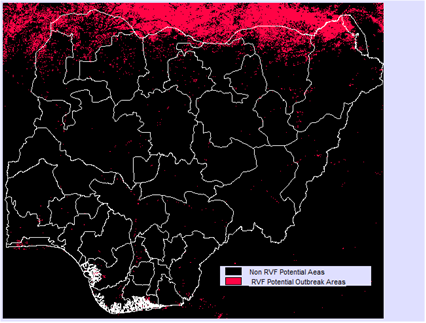
Figure 2. NDVI Climatology map of potential risk areas of arthropod-borne viral disease across Nigeria. These are areas subjected to extreme inter-annual climatic variability linked to the warm ENSO periods of September 2014 to December 2015.
A further look at Component two image in Figure 1b shows a clear distinctive pattern of changing seasons mostly across the Savanna zone but with high positive NDVI anomaly around the Niger Delta area and southermost part of Cameroon. Furthermore, (Piou et al; 2018) have shown that there is great potential of NDVI dataset derived from MODIS in assessing ecological conditions for monitoring recession areas and detection of vector-borne disease outbreaks. While Yelwa, (2008) and Kemi et al; (2024) have shown that there is a close relationship between climate change and most reported cases of diseases due the changing climate, it was based on this assertion that the study by Yelwa, (2008) who utilised a very coarse spatial NDVI satellite imageries from AVHRR confirmed some potential areas across Nigeria where animal vector-borne diseases linked to the ENSO phenomenon have occurred with mortality in sheep and cattle. Thus, the study conducted by Adesola and Idris (2022) has shown that Sokoto, Katsina, Kano, Kaduna and Borno states in the northern part of Nigeria have the potential to give RVF virus opportunity to propagate very fast, thereby causing an economical threat to farmers, and according to them, the increased membrane fluidity and cytoskeletal dynamics that brought about warmer temperatures in these states that are most likely to facilitate the transmission of this RVFV. A close look at the map of potential risk areas for RVFV across Nigeria and other surrounding locations in Figure 2 shows that there is a strong correlation with the Climate event between September 2014 to December 2015. As most of tropical rain forest areas of Africa do not fall within the risk zones of such arthropod vector-borne diseases, they are however, most likely to occur in a wide range of ecological zones especially where there is deforestation according to reported RVFV epizootic cases in cattle within the deforested southern tropical rainfall zone of Madagascar (Morvan et al; (1991). Based on the maps in Figures 1 (a & b) and Figure 2 there is an indication of NDVI anomaly patterns in the Niger Delta area which has long suffered some form of environment destructions including deforestation (Boele et al; 2001), as well as those states which Adesola and Idris, (2022) have shown to have the potential of allowing RVF virus to propagate very fast. It is therefore, clear that RVFV epizootic cases are also most likely to occur in such deforested tropical forest areas of the Niger delta and, particularly when there is serious flooding (Umar and Gray, 2023). On the other hand, since the RVFV enzootic can be from various species of animals such as goats, sheep, cattle and camels (Adesola and Idris, 2022), the pattern of the spread on the map of potential risk areas particularly in the southern part of Niger Republic in Figure 2 corresponds to the report by Lagare et al; (2019) and Anywaine et al; (2022) of the emergence of this disease. It is also most likely due to infections among livestock handlers across the study area (Opayele et al; 2018), as well as infections among occupationally exposed persons particularly in northern part of Nigeria (Oragwa et al; 2022). The pattern of spread and pockets in different locations could also be attributed to the movement of the nomadic rearers of these animals that are infected with the RVF virus and the mass transportation of the animals in long trailers and other commercial vehicles from the northern to the southern part of the country.
CONCLUSIONS
The conclusion drawn from this geospatial assessment revealed that Satellite data can be useful for periodic monitoring of potential areas at risk of RVF Virus. Remote Sensing and GIS can be a cost-effective component of disease control campaign because data acquired through satellites remote sensing can assist in mapping out potential areas that are at risk to animal and human vector-borne diseases. Time-series MODIS-NDVI dataset used in this study is now freely available to the world scientific community and can be used periodically by health authorities and other stakeholders so as to advise policy makers accordingly. The government should be willing to strictly implement approved polices particularly issues related to human and animal health for environmental sustainability, otherwise the efforts of other stakeholders would be in vain. Although this geospatial assessment did not incorporate groundtruthing in the analysis of the satellite imageries or utilised blood specimen for laboratory analysis, the result derived from this study still provided relevant information for public health authorities such as epidemiological departments for a sustainable environmental health and livestock production and management in Nigeria under the present economic situation. Further studies should utilise a better spatial resolution dataset with groudtruthing to target vulnerable areas as strategies for prevention and control.
ACKNOWLEDGEMENT
The Researchers are grateful to the National Oceanic Atmospheric Administration (NOAA) for the National Aeronautics Space Administration (NASA)’s Moderate Resolution Imaging Spectrometer (MODIS) Climate Modelling Grid (MODIS-CMD) for the use of Normalised Difference Vegetation Index (NDVI) dataset at 250 meters spatial resolution without which this study would not have been possible. We are also grateful to the anonymous reviewers and editor for their assistance.
CONFLICTS OF INTEREST.
The authors affirm that there are no conflicts of interest.
REFERENCES
- Abdullahi, M., and Yelwa, S. A. (2020). Application of MODIS-NDVI for Vegetation Change Detection across Nigeria from 2000 to 2019. Kaduna State University Environmental Science Journal, 1, 40-47.
- Adesola, R. O. and Ibrahim Idris, I. (2022). The Existence of Rift Valley Fever Virus in Nigeria: Past, Present, and Future. Intersect, Vol 16, No 1, 1-13. https://www.researchgate.net/publication/367545116.
- Adeyeye, A. A., Ekong, P. S. and Pilau, N. N. (2011). Rift Valley Fever : the Nigerian Story. Veterinaria Italiana, 47, (1) 35-40. www.izs.it/vet_italiana
- Anyamba, A., Tucker, C. J. and Eastman, J.R. (2001). NDVI anomaly patterns over Africa during the 1997/98 ENSO warm event. International Journal of Remote Sensing, 22:1847 – 1859.
- Anywaine, Z., Lule, S. A., Hansen, C., Warimwe, G. adnd Elliot, A. (2022). Clinical Manifestation of Rift Valley Fever in Humans : Systematic Review and Meta-Analysis. PLOS – Neglected Tropical Diseases. 16(3): e0010233. http://doi.org/10.1371/journal.
- Boele, R., Fabig, H. and Wheeler, D. (2001). Shell, Nigeria and the Ogoni. A study in Unsustainable Development I. The Story of Shell, Nigeria and the Ogoni People – Environment, Economy, Relationships : Conflict and Prospects for Resolution. Sustainable Development, 9:74 – 86.
- Bron, G. M., Strimbu, K., Cecilia, H., Lerch, A., Moore, S. M., Tran, Q., Perkins, T, A. and ten Bosch, Q. A. (2021). Over 100 Years of Rift Valley Fever : A Patchwork of Data on Pathogen Spread and Spillover. Pathogens, 10, 708. http://doi.org/10.3390/
- Carrol, S. A., Reynes, J., Khristova, M. L, Andriamandimby, S. F., Rollin, P. E. and Nichol, S. T. (2011). Generic Evidence for Rift Valley Fever Outbreaks in Madagascar Resulting from Virus Introduction from the East African Mainland rather than Enzootic Maintenance. Journal of Virology, Page 6162 6167. doi:10,1128/JV1.000335-11.
- American Society for Microbiology.
- Daubney, R. Hudson, J. R. and Garnham, P. C. (1931). Enzootic hepatitis or Rift Valley fever : an undescribed virus disease of sheep, cattle, and humans from East Africa. Journal Pathology Bacteriololgy, 34, 545-7910.
- Didan, K. (2015). MODIS13Q1 MODIS/Terra Vegetation Indices 16-Day L3 Global 250m SIN Grid V006. NASA EOSDIS Land Processes. DAAC https://doi.org/10.5067/MODIS/MOD13Q1.006
- Ebogo-Belobo, J. T., Kenmoe, S., Abanda, N. N., Bowo-Ngandji, A., Mbaga, D. S., Magoudjou-Pekam, J. N., Kame-Ngasse, G. I., Tchatchouang, S., Menkem, E. Z., Okobalemba, E. A., Noura, E. A., Meta-Djomsi, D., Maidadi-Foudi, M., Kenfack-Zanguim, J., Kenfack-Momo, R., Kengne-Nde, C., Esemu, S. N., Mbacham, W. F., Sadeuh-Mba, S. A., Ndip, L. and Njouom, R. (2023). Contemporary Epiemiolgical data of Rift Valley Fever Virus in Humans, Mosquitoes and other Animal Species in Africa : A systematic Review and Meta-Analysis. Veterinary Medicine and Science, John Wiley and Sons Ltd. Doi:10.1002/vms3.1238
- Green, R. M. and Hay, S. I. (2002). The potential of Pathfinder AVHRR data for providing surrogate climatic variables across Africa and Europe for epidemiological applications. International Journal of Remote Sensing, 79:166-175.
- Hay, S. I., Packer, M. J. and Rogers, D. J. (1997). The impact of remote sensing on the study and control of invertebrate intermediate hosts and vectors for disease. International Journal of Remote Sensing, 18:2899 – 2930.
- Ikegami, T., and Makino, S. (2011). The Pathogenesis of Rift Valley Fever. Viruses, 3(5), 493-519. doi.org/10.3390/v3050493.
- Jorn P. W., Scharlemann, David Benz, Simon I. Hay, Bethan V. Purse, Andrew J. Tatem, G. R. William Wint, David J. Rogers (2008). Global Data for Ecology and Epidemiology: A Novel Algorithm for Temporal Fourier Processing MODIS Data. PLoS ONE 3(1): e1408. doi:10.1371/journal.pone.0001408
- Kemi, S., Mayowa, O. and Mojisola, A. (2024). Evaluation of the Correlation Between Climate Change and the Most Reported Cases of Diseases due to Climate Change in the Study Area over the period of 11 years (2010-2020) in selected South-Western States (Ekiti, Osun and Ondo), Nigeria. International Journal of Research and Scientific Innovation (IJRSI). ISSN N0. 2321-2705. DOI: 10.51244/IJRSI. Volume XI Issue III,
- Lagare, A., Fall, G., Ibrahim, A., Ousmane, S., Sadio, B., Abdoulaye, M., Alhassane, A., Mahaman, A. E., Issaka, B., Sidikou, F., Zaneidou, M., Bienvenue, B., Mamoudou, H. D., Diallo, A. B., Kadadé, G., Testa, J., Mainassara, H. B., & Faye, O. (2019). First occurrence of Rift Valley fever outbreak in Niger, 2016. Veterinary Medicine and Science, 5(1), 70-78.
- Linthicum, K. J., Anyamba, A., Tucker, C.J., Kelley, P.W., Myers, M. F. and Peters, C. J. (1999). Southern Oscillation Index, sea surface temperature and satellite vegetation index indicators to forecast Rift Valley fever epizootics/epidemics in Kenya. Science, 285:397 – 400.
- Logan, T.M., Davies, F. G., Linthicum, K. J., and Ksiazek, T. G. (1992). Rift Valley Fever Antibody in human sera collected after an outbreak in domestic animals in Kenya. Transaction of Royal Spciety of Tropical Medicine and Hygiene, 86:202-203.
- Luxon, N. and Pius, C. (2012). Climate Change Risk and Vulnerability Mapping and Profiling at Local Level Using the Household Economy Approach (HEA). Journal of Earth Science & Climatic Change. Vol. 3 No. 3 Page 1-7. DOI: 10.4172/2157-7617.1000123.
- Mcintosh, B. M. and Jupp, P. G (1981). Epidemiological aspects of Rift Valley Fever in South Africa with references to Vectors. Contribution to Epidemiology and Biostatics, 3:92-99.
- Morvan, J., Saluzzo, J. F., Fontenille, D., Rollin, P. E. and Coulanges, P. (1991). Rift Valley Fever on the coast of Madagascar. Research in Virology, 142: 475 – 482.
- Neteler, M. (2005). Time Series Processing of MODIS Satellite Data for Landscape Epidemiological Applications. International Journal of Geoinformatics, Vol. 1, No. 1, March 2005
- Opayele, A. V., Odaibo, G. N., and Olaleye, O. D. (2018). Rift valley fever virus infection among livestock handlers in Ibadan, Nigeria. Journal of immunoassay & immunochemistry, 39(6), 609–621.
- Oragwa, A. O., Oragwa, F. C., and Oluwayelu, D. O. (2022). Serologic evidence of silent Rift Valley fever virus infection among occupationally exposed persons in northern Nigeria. The Journal of Infection in Developing Countries, 16(05), 881-887.
- Patz, J. A., Graczyk, T. K., Geller, N., & Vittor, A. Y. (2000). Effects of Environmental Change on Emerging Parasitic Diseases. International Journal for Parasitology, 30, 1395-1405. https://doi.org/10.1016/S0020-7519(00)00141-7
- Piou, C., ; Gay, P; Benahi, A. S.; Abdallahi, M., Ebbe; O.B., Chihrane J.; Ghaout J.; Cisse, S. ; Diakite, F; Lazar, M.;
- Cressman K; Olivier Merlin O., .and ; Maria-José Escorihuela. M. (2018). Soil moisture from remote sensing to forecast desert locust presence. Journal of Applied Ecology. DOI: 10.1111/1365-2664.13323
- Pona, H. T; Xiaoli, D; Ayantobo, O.O. and Tetteh, N. D. (2021). Environmental health situation in Nigeria: current status and future needs. Heliyon, Vol. 7, page 1-12. www.cell.com/heliyon
- Prajesh, P. J., Kannan, B., Pazhanivelan, S., Kumaraperumal, R. and Ragunath, K. P. (2019). Analysis of Seasonal Vegetation Dynamics Using MODIS Derived NDVIand NDWI Data: A Case Study of Tamil Nadu. Madras Agric. J., 2019; doi:10.29321/MAJ 2019.000275.
- Rhew, I. C., Stoep, A. V., Kearney, A., . Smith, N. L. and Dunbar, M. D. (2011). Validation of the Normalized Difference Vegetation Index as a measure of neighborhood greenness. Ann Epidemiol. 2011 December ; 21(12): 946–952. doi:10.1016/j.annepidem.2011.09.001.
- Santra, P. and Chakraborty, A. (2011). Analysis of Seasonal and Annual change of vegetation in the Indian Thar Desert using MODIS data. V. XXXVIII-8/W20, ISPRS Bhopal Workshop, 8 November, 2011, pp175-178.
- Sutherst, R, W. (1998). Implications of global change and climatic variability for vector-borne diseases : generic approaches to impact assessments. International Journal for Parasitology, 28:935-945.
- Tucker, C. J., Hielkema, J. U. and Roffey, J. (1985). The potential of satellite remote sensing of ecological conditions for survey and forecasting desert-locust activity. International Journal of Remote Sensing, 6:127-138.
- Umar, N. and Gray, A. (2023) Flooding in Nigeria: a review of its occurrence and impacts and approaches to modelling flood data, International Journal of Environmental Studies, 80:3, 540-561, DOI: 10.1080/00207233.2022.2081471.
- Xiao, Z., Liang, S., Wang, J. Y., Zhao, X. X. and Song, J. (2016). “Long-Time-Series Global Land Surface Satellite Leaf Area Index Product Derived From MODIS and AVHRR Surface Reflectance, ” IEEE Trans Geosci Remote Sens, vol. 54, no. 9, pp. 5301-5318, Sep. 2016, DOI:10.1109/TGRS.2016.2560522.
- Yelwa, S. A. (2008). Broadscale Vegetation Change Assessment across Nigeria from Coarse Spatial and High Temporal Resolution AVHRR Data. Cuvillier Verlag, Göttingen Press, Göttingen, 350 p.
- Yelwa, S. A. and Dangulla, M. (2013). The impact of climate change on Nigerian Landcover during the El-Nino Southern Oscillations (ENSO), event of 1997 to 1998. Research Journal of Applied Sciences, 8 (1), 33-41.
- Zhang, Y., Xiao, X. M., Wu, X. C., Zhou, S., Zhang, G. L., Qin, Y. W., and Dong, J. W. (2017). “A global moderate resolution dataset of gross primary production of vegetation for 2000-2016,” Sci. Data., vol. 4, pp. 170165, Oct, 2017, DOI: 10.1038/sdata.2017.165.