
Strategic for Mitigating Urban Disasters on the Northern Coast of Banda Aceh City, Indonesia
- Mirza Irwansyah
- Cut Nursaniah
- Laila Qadri
- 385-397
- Mar 19, 2024
- Geology
Strategic for Mitigating Urban Disasters on the Northern Coast of Banda Aceh City, Indonesia
Mirza Irwansyah*, Cut Nursaniah, Laila Qadri
Department of Architecture and Planning, Faculty of Engineering, Universitas Syiah Kuala, Banda Aceh 23111, Indonesia
*Corresponding Author
DOI: https://doi.org/10.51244/IJRSI.2024.1102030
Received: 05 February 2024; Accepted: 16 February 2024; Published: 19 March 2024
ABSTRACT
Many cities in Indonesia are situated in hazard-prone areas—along coasts or on floodplains, on top of or near seismic faults, in the shadow of volcanoes, and in areas prone to tropical cyclones and extreme storms, including tsunamis. The northern coastal area of Banda Aceh city is currently still vulnerable to natural disasters that endanger settlements there, such as tidal waves, coastal abrasion, strong winds, and tsunamis. Alue Naga village is a representative of this phenomenon: The village remains arid without optimal greening even after reconstruction efforts following the tsunami on December 26, 2004, and even though Banda Aceh city Spatial Planning documents designated Alue Naga village as a protected area for developing natural tourism. Therefore, it is important to conduct studies aimed at mitigating the impacts of natural disasters on such settlements as Alue Naga. By referring to settlement standards based on disaster mitigation, research studies were carried out of current land use including canopy cover, current community livelihoods, and efforts to balance coastal forestation protection needs with support for farmers’ aquaculture in reducing the risk of natural disasters. The results showed that coastal and river boundaries in the study area were not optimally protected with either soft or hard mitigation techniques, and the housing infrastructure provided for disaster mitigation was also not optimal. There is still low canopy density in the study area, and it is recommended that layered canopies be planted at the coastal areas to break the tidal waves, buffer backflow, prevent coastal abrasion, and support silvofishery in the pond areas. A sustainable coastal city management considering the disaster risk should, therefore, be incorporated within the decision making for the protection of the coastal city area.
Keywords: Alue Naga village, Banda Aceh city, coastal settlements, disaster mitigation, and natural disasters.
INTRODUCTION
Coastal cities have experienced tremendous growth in recent decades, especially in Africa and Asia (Barragan et al. 2015). Many of cities in Indonesia are situated in hazard-prone areas—along coasts or on floodplains, on top of or near seismic faults, in the shadow of volcanoes, and in areas prone to tropical cyclones and extreme storms, including tsunamis. These natural hazards tend to exert even greater impacts since cities concentrate people and economic assets, including large-scale infrastructure and properties (Parera et al. 2022). Both the government of Indonesia and communities have been starting to realize the importance of mitigation plans for responding to disasters, especially in urban region. Geographical location and geological structure make Indonesia as one of the countries prone to disasters, including earthquakes, floods, landslides, storms, tsunamis, forest and land fires and volcanic eruptions. Indonesia is geographically located at the junction of three world plates: the South East-Asian Plate, the Indo-Australian Plate, and the Pacific Plate, which makes its territory prone to disasters (Figure 1). Nearly all areas of the Indonesian archipelago have experienced numerous disasters, but disasters are culturally considered destiny, so that individuals and leaders do not take casualties and economic losses from disasters as opportunities for learning for the future. It is now becoming imperative to analyze and develop or refine spatial planning policies to minimize the environmental effects of disasters (Edyanto, 2011). Spatial planning is currently regarded as a valuable panoptic tool towards sustainable development, disaster risk reduction, and climate change adaptation (Shaw et al. 2017). For instance, the devastating damage that hit the city of Banda Aceh in 2004 earthquake-tsunami was attributable to the vertical structure of the coastline and the resulting lack of barriers against waves entering the city.
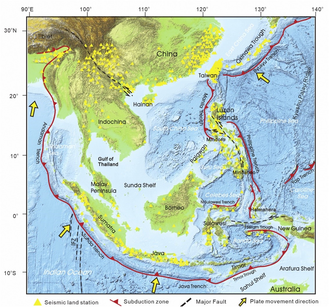
Figure 1. The South East-Asian Plate, the Indo-Australian Plate, and the Pacific Plate.
The coast along an urban area, when it is well maintained, can play a role in the city, affecting the urban identity, enriching the visual aspects of life there, and overall affecting the quality of life in a positive way. A low-lying coastal area is often vulnerable to multiple hazards. The city of Banda Aceh, a coastal city located at the western most tip of Sumatra Island, is vulnerable to various disasters such as the earthquake and tsunami back in 2004. Aquaculture ponds, buildings and bare land are the top three most pre-dominant land covers in Banda Aceh coast (Meilianda et al. 2019). An area in the city of Banda Aceh that was severely damaged at that time was the Alue Naga fishermen village, which is located on the north coast of Banda Aceh city (Figure 2). Because there was little coastal vegetation to block the breakthrough of waves, the collector road and the river that divides Alue Naga behaved as a tsunami flow tunnel at that time (Nursaniah et al. 2020). Wetlands feature in the coastal area of Banda Aceh, are most likely the most vulnerable natural entity to the effect of future sea-level rise. While the wetlands such as lagoon, river and mangrove mostly have been existing for long history in Banda Aceh (Meilianda et al. 2019).
Spatial planning can positively contribute to reducing disaster risk and enhancing the resilience of cities by providing secure land and its safe use for socially and economically disadvantaged city residents through participatory processes; reflecting infrastructure provision in spatial plans; and ensuring that poverty reduction and addressing socio-environmental and spatial inequalities are development criteria for urban development and improvement (Shaw et al. 2017). Moreover, it “creates the preconditions required to achieve a type of land use that is environmentally sustainable, socially just and desirable, and economically sound. It thereby activates social processes of decision- making and consensus building concerning the utilization and protection of private, communal, or public areas” (BMZ, 2012). The most important aspects are the implementation of appropriate planning policies, laws, spatial plans, urban standards, and regulations; the inclusion of diverse stakeholders and voices; strengthening the understanding of the spatial, regional, and relational aspects of disasters, disaster risk, and disaster impacts; further mitigating and adapting to climate change and protecting ecosystems; and facilitating links between different scales of responsibility (UPRL, 2020).
Alue Naga is prone to natural disasters such as earthquakes, tsunamis, coastal abrasions, and tidal waves (RTRW Banda Aceh, 2009), but after the disaster, the village was designated a protected area with natural tourism potential and a low settlement density. However, the area still looks barren because there has been little greening on the coast or in housing areas. Separately, most housing that was constructed by national and international donor agencies is still vulnerable to coastal abrasion and tidal waves (Edyanto, 2011).
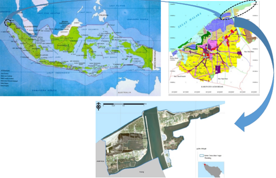
Figure 2. Indonesia, Banda Aceh City, and Alue Naga village.
Certain conditions such as those shown in Figure 3 make settlements, residents, livelihoods, and infrastructure vulnerable to natural disasters. The conditions of Alue Naga as shown in the figure are the same for the entire north coast of Banda Aceh, which makes Alue Naga a worthy area for studying how to improve the safety conditions. Irwansyah et al. determined that disaster risk reduction measures on the Banda Aceh coast are still sporadic and that there has been no commitment to a more detailed institutional policy (Irwansyah et al. 2019).
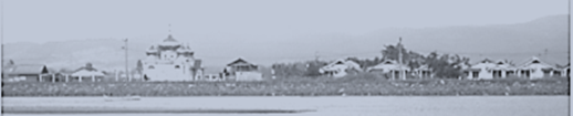
Figure 3. The barren village of Alue Naga is an example of a settlement on the north coast of Banda Aceh city.
Therefore, the government needs to pay serious attention to the constraints of physical development against the risk of natural disasters. Development on the coast needs to incorporate disaster mitigation that minimizes the devastating impacts of the area’s inevitable natural disasters. Sukawi emphasized the importance of creating disaster-safe zones in restructuring disaster-prone settlements; safe zones could include safety shelters or green open spaces, for instance (Sukawi, 2008). The beach along the coast is straight and planted with hard plants (mangroves, nipah, waru, coconut trees) that are good and suitable for protection, and Naryanto highlighted the need for more greening along coastal areas directly adjacent to the sea to withstand tsunami waves (Naryanto, 2008). Planning and protection of natural beaches can be used as solutions to physical and environmental research problems formulated previously in coastal areas, which are also tourism areas. The conclusion of this theoretical study on green open space is that open space with natural functions that are very important for security, safety, comfort, and sustainability must be prioritized, especially in land use (Meutia, 2021). Coastal vegetation that can dampen tsunamis includes mangroves, coconut, oil palm, and coastal forests, and coastal forests have physical, ecological, and socio-economic functions that are very important for the surrounding communities (Anonymous, 2004). On the other hand, mangrove forest colonies started to expand further inland in 2011, particularly on the southwest part of the coastal area, and on the west side of Alue Naga Floodway Canal. Despite their minor occupation at the coastal area, the mangrove forest areas have been expanded slightly beyond the pre-tsunami condition (Meilianda et al. 2019).
Diposaptono and Budiman found that tsunami mitigation can include both physical and non-physical interventions (Diposaptono et al., 2005). Physical efforts include breakwaters, sea walls, shelters, artificial hills, coastal vegetation, and retrofitting, where nonphysical efforts include education, training, community awareness, spatial planning, zoning, relocation, laws and regulations, and integrated coastal zone management (Diposaptono et al., 2008). According to Nugroho, the Indonesian people still have limited understanding of tsunamis, and therefore, socialization to the dangers needs to be one of the top priorities in tsunami disaster mitigation efforts (Nugroho et al., 2015). In short, disaster mitigation efforts along the Indonesian coast need to incorporate levels of risk and the characteristics of the coastal areas. The main objective is to reduce the destructive impacts of disasters on both lives and the economy.
MATERIALS AND METHODS
To determine the factors that influence natural disaster mitigation, this study involved using action research methods, which to provide an overview of the existing phenomena in the study area. Literature was reviewed related to existing theories, and data were acquired from relevant agencies to establish the current and ideal morphology of the physical area for protection from the sea.
To determine the potential disaster risks in the study area, variables such as geomorphology, abrasion (accretion) on the coast (m/year), slope (%), changes in relative water level (mm/year), and average wave height (m) were considered. Next, a land cover analysis was conducted to recommend a sustainable settlement planning strategy; the parameters that were observed included the land cover and use before and after the disaster and composition of community livelihoods related to the use of mangrove forests. To deepen the study, a search was also carried out on secondary data and relevant previous research results. Based on the data collection method, the technique of determining the criticality level of green open space in the study area was measured using Geographic Information System (GIS) technology and senses (Satellite citra). The measured and reviewed data were combined to produce an effective land use planning strategy. The studies conducted entailed understanding the designated land types, reviewing existing mitigation types, reviewing and updating existing land uses, and planning for post-disaster development.
RESULTS AND DISCUSSION
- Understanding of the context of the location
Banda Aceh, including the study area, has a gentle slope. The study area is flat, with a slope of 0 to 2% at 1 meter above sea level along 89% of the area. Syamsidik et al. found that this elevation had resulted in tremendous erosion at that location during the 2004 tsunami; specifically, the coastline retreated several hundred meters (Syamsidik et al. 2019). The satellite imagery shown in Figure 4 shows how the shape of the coast changed from 2002 to 2017. Beaches along open bays are particularly vulnerable to erosion.
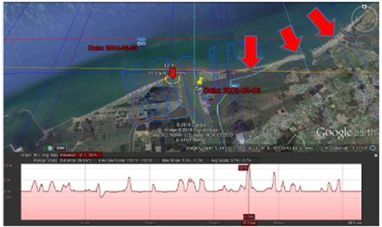
Figure 4. The coastal geomorphology of the study area makes it vulnerable to erosion from strong waves.
The coast is dominated by sandy beaches with gentle reliefs facing the Strait of Malacca, and the sandy soils are very susceptible to erosion from tidal waves. The beach in this study area contains only coastal pine vegetation that grows far apart and coconut trees. However, at the ponds and river estuaries, the sand mixes with muddy soil, although planting mangroves can strengthen the soils around ponds. Table 1 presents a breakdown of the land use in Alue Naga village; notably, there is little vegetation as land cover and large areas dedicated to ponds. This layout means that there little coastal forest available for protection and thus high risk for damage from natural disasters, and the government’s commitment to coastal protections is crucial for the sustainability of coastal ecosystems.
Table 1. Land Cover of Alue Naga Village
| No. | Land Use | Hectare | Percentage |
| 1. | Coastal forest | 3.45 | 1.05 |
| 2. | Collector’s path | 8.13 | 2.48 |
| 3. | The sea | 98.12 | 29.99 |
| 4. | Beach | 18.92 | 5.78 |
| 5. | Settlement | 16.7 | 5.10 |
| 6. | Plantation | 7.28 | 2.22 |
| 7. | Swamp | 3.22 | 0.98 |
| 8. | River | 36.7 | 11.22 |
| 9. | Pond | 92.62 | 28.31 |
| 10. | Open ground | 39.49 | 12.07 |
| 11. | Embankment | 2.57 | 0.79 |
| Total | 327.2 | 100 | |
Figure 5 shows the results of the vegetation analysis, indicating sparse canopy density over most areas from the coast to the settlement. The minimum requirement, however, for the thickness of coastal forest is 50 meters. The vegetation that grows in the study area is a very few types of mangroves, a few coastal cypresses, banana, and coconut plantations, with the largest portion consisting of shrubs. This imbalanced land cover results in ecological damage such as foul-smelling community well water, small catches and few fisheries, abrasion, and the loss of important coastal plant species of economic value.
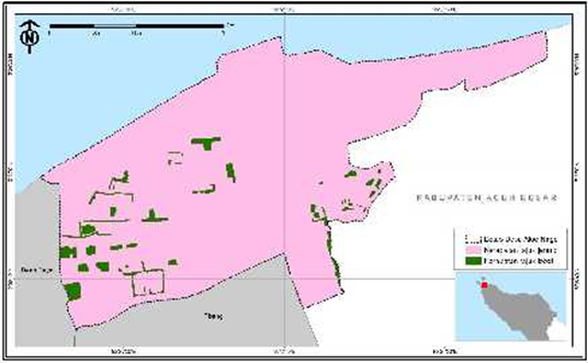
Figure 5. Crown density in Alue Naga.
- Review of the existing mitigation types
Based on information from the community and the Banda Aceh city spatial plan document, environmental disasters identified as threatening the coastal settlements in the study area are tidal waves, sea breezes, coastal abrasion, and tsunami. In the document, the study area is designated as a protected area whose sustainability must be protected. Current mitigation types at the study location consist of the following.
- Hard Protection
The primary hard protection along the coast of Banda Aceh city is tidal embankments built along the coast made of piles of large stones that form a coastal belt. In addition to reducing wave energy, this construction is intended to restore the coastline to its original position. However, the embankments are not continuous along the coastline, and the low altitude prevents the effective restraint of seawater runoff inland. Notably, the embankments that extends perpendicular to the coastline at estuary mouths, called groins, have economic, recreational, and aesthetic benefits. Figure 6 shows the existing hard protection in the study area. Apart from the embankment, there is also a sign warning against strong winds and tsunamis, which is shown in Figure 7.
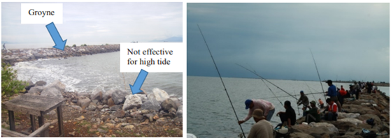
Figure 6. Existing hard protection in the study area.
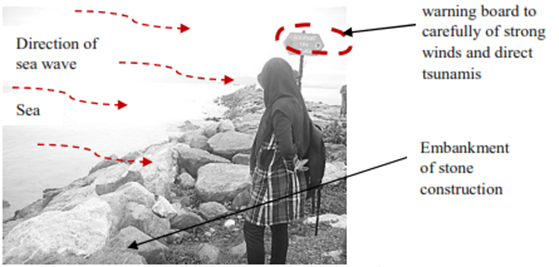
Figure 7. Embankments and warning sign in the study area.
Figure 8 shows how rock mounds are configured to protect the coast; these groins perpendicular to the coastline. The embankment structure parallel to the coastline is intended to withstand the wave energy, and the embankment prevents offshore sediment erosion. The main problem is that outside the embankment area, the configuration of buildings creates tunnels that speed waves through the settlements, causing local scouring around the buildings. This configuration has also changed the current circulation patterns along the coast.
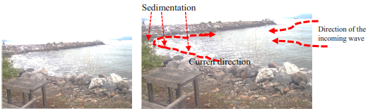
Figure 8. Groin in the study area causes coastal erosion and sedimentation.
Based on existing mitigation conditions, for safety and environmental stability in the study area, a buffer zone must be added as soft protection to further optimize the coastal mitigation efforts. For instance, the low, flat topography makes the area ideal for the effective deployment of reforestation, although effects are not immediately visible.
- Review and renewal of existing land use
The study area became nonecological after the 2004 tsunami; in fact, the retreat of the coastline inundated some settlements and created new water bodies, and erosion caused by the waves shifted residential lands in general. In accordance with the spatial planning policies for protected areas and coastal area management, disaster mitigation efforts have included planting vegetation types that are amenable to coastal and river boundary conditions as well as reforesting pond areas. In the existing pond zones, Rhizophora sp mangroves had previously been overgrown and then converted; therefore, these areas are highly appropriate for replanting with this mangrove species at an effective thickness for natural protection against the speed of tidal waves and limit coastal erosion. In 2009, five years after the tsunami, mangrove replantation began and is still ongoing, but the plantings failed to protect residents from deaths, meaning that the canopy thickness was not optimal for disaster mitigation. The mangroves likely did not grow effectively because they were imported and incompatible with conditions along the Aceh coast; therefore, native or more adaptable species need to be planted in the study area. In addition, the reconstructed houses were located farther inland at a minimum distance of 100 meters from the coast; the two primary housing types are styled houses and landed houses, but landed houses are susceptible to tidal waves and humidity. Figure 8 shows the conditions 18 years after the reconstruction, reflecting that there is no buffer zone at the coastal and river boundaries. The ponds are also still barren because of the economic limitations of the community.
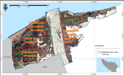
Figure 9. Condition of the study area 18 years after the tsunami disaster.
Harada and Imamura, researchers at Tohoku University, determined that a coastal forest with a thickness of 200 meters, a density of 30 trees per 100 m2, and a tree diameter of 15 cm, can reduce 50% of tsunami wave energy with a height of 3 m (Harada et al. 2003), supporting Diposaptono and Budiman’s finding that tree canopy plays a very important role in resisting tidal waves and backflow (Diposaptono et al 2008). Meanwhile, Pramudji determined that it is difficult to grown mangroves in open coastal sand areas because they are more suitable and easier to grow in river estuaries (Pramudji 2010). To maximize the protections from vegetation, more appropriate trees have been planted (Figure 10), and tree plantings have been arranged in ways that maximize their effects as buffers against tidal waves, although aesthetic factors have also been considered. Specifically, plants with a low canopy are placed at the front, and the higher canopy is toward the back, which functions to buffer back flow. Plantation trees and other broadleaf crops should be planted behind buffer forests leading to settlements (Tanaka et al. 2007).
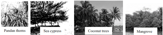
Figure 10. Types of plants suitable for the study area.
- Planning for post-disaster development.
- Buffer Zone
The buffer zone is directly adjacent to the shore and the mainland and should be forested; the intention is to protect the area around the coast against abrasion, tidal waves, strong winds, and tsunamis. To preserve marine biota, the width of the coastal green belt is 50 meters, and the green belt width of the river estuaries is 10 meters. However, for coastal protection against tsunami waves, a green belt width is recommended of at least 100 meters from the coastline inland based on the distance of the coastline from the settlement. Figure 11 shows the recommended coastal and river boundaries with aesthetically pleasing vegetation arrangements.
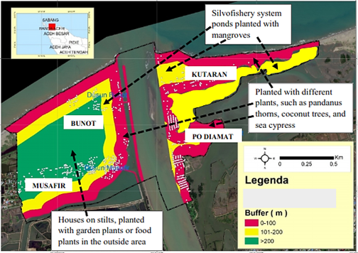
Figure 11. Recommendations for coastal, river, and pond boundaries in the study area.
The flat and short geomorphology of the Alue Naga coast is one of the factors that makes this area important for planting. Mangroves are coastal plants that can be relied on as buffer zones, but the west coast of Sumatra, including Banda Aceh and Alue Naga, has beaches that are dominated by sand with high-energy waves, and these conditions are not suitable for mangroves. Other coastal plants are ideal for growing in the study area, and Figure 12 shows a recommended coastal boundary arrangement for the study area.
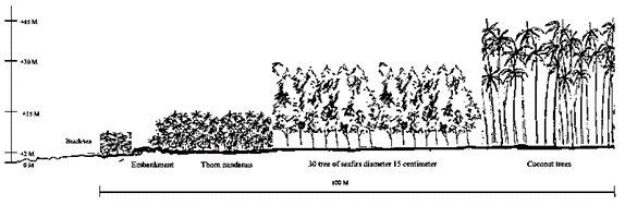
Figure 12. Recommendations for the zoning of coastal boundaries in the study area.
2. Ecological ponds
Before the tsunami, pond farmers in the study area tended non-mangrove ponds, many of which had comprised mangrove vegetation before they were converted to ponds. For the future development of the ponds, mangroves were planted in pond plots, known as the silvofishery system; the concept of silvofishery is to bridge the conflicts between coastal protection and seafood (brackish water fish, shrimp, and crab) ponds. Silvofishery is a technical approach that consists of integrating fish, shrimp, and soft crab farming activities with maintaining mangrove forests. Ponds are built with mangroves in them that can simultaneously function as nature conservation (habitat), green open space, production economy, and recreation.
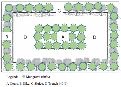
Figure 13. Recommended silvofishery system for the study area.
CONCLUSIONS
The study area of Alue Naga village is an example of settlements along the northern coast of Banda Aceh city, and it is highly prone to damage from natural disasters (tidal waves, coastal abrasion, wind, tsunamis). The existing land allotment for housing and the existing settlement infrastructure are not optimal for disaster mitigation in Alue Naga. Mitigation efforts should ideally incorporate both hard and soft protection interventions.
GIS analysis showed that the distribution of crown density in the study area was rare. The tree canopy plays a significant role in resisting tidal waves and backflow, and therefore, increasing the number and types of vegetation is recommended. Specifically, a layered canopy with higher vegetation in the back will function to break the tidal waves, buffer backflow, and prevent coastal abrasion.
The area directly adjacent between the coastline and the land must be forested to protect the area around the coast against abrasion, tidal waves, strong winds, and tsunamis. Only a small proportion of the coastal and river boundaries in the study area is covered with vegetation, but the flat and short coastal geomorphology is one of the factors that makes this area very important for planting. The current pond zones were previously mangrove habitats, so effective silvofishery should incorporate mangrove plantings in the pond plots. Silvofishery can bridge the conflicts of interest between coastal protection and aquaculture needs.
ACKNOWLEDGEMENTS
This research was carried out to financial support from DRPM Dikti (Ministry of Education and Culture, the Republic of Indonesia), which is managed by the Institute for Research and Community Services at the Universitas Syiah Kuala. For that, we would like to thank the two institutions.
DECLARATIONS
Ethics approval and consent to participate
Not applicable.
Consent for publication
Not applicable.
Availability of data and materials
The datasets used and/or analyzed during the current study are available from the corresponding author on reasonable request.
Competing interests
The authors declare that they have no competing interests.
Funding
This work in the design of the study and collection of data were supported by the Ministry of Education and Culture the Republic of Indonesia.
Author contributions
Conceptualization, MI, CN and LQ; data curation, MI, CN, and LQ; formal analysis, MI and CN; investigation, MI, CN, and LQ; methodology, MI and CN; project administration, MI and CN; resources, MI and CN; writing—original draft, MI, and CN; writing—review and editing, MI, CN, LQ, and MM. All authors read and approved the final manuscript.
REFERENCES
- Anonymous, 2004, Pedoman Mitigasi Bencana Alam di Wilayah Pesisir dan Pulau-Pulau Kecil. Direktorat Jenderal Pesisir dan Pulau-Pulau Kecil. Departemen Kelautan dan Perikanan. Jakarta.
- Barragan, J.M. and de Andres, M. 2015. Analysis and trends of the world’s coastal cities and agglomerations. Ocean & Coastal Management 114; 11-20
- BMZ. Land Use Planning: Concept, Tools and Applications; GIZ: Bonn, Germany, 2012.
- Diposaptono S, and Budiman, 2008. Hidup Akrab dengan Gempa Bumi dan Tsunami. Penerbit Buku Ilmiah Populer Bogor.
- Diposaptono, S dan Budiman. 2005. Tsunami. Bogor: Buku Ilmiah Populer.
- Edyanto, 2011, Analisa Kebijakan Penataan Ruang untuk Kawasan Rawan Tsunami di Wilayah Pesisir. Jurnal Teknik Lingkungan Vo. 12, No. 3 Hal. 309-318, September 2011, ISSN: 1441-318X, Jakarta.
- Harada, K and Imamura, F. 2003, Study on the Evaluation of Tsunami Reducing by Coastal Control Forest for Actual Conditions. Conference: Asian and Pacific Coasts 2003 – 2nd International Conference. Doi: 10.1142/979812703040_0004
- Irwansyah, Nursaniah, Qadri, and Mariana, 2019, Vulnerability Analysis in the Northern Coast Region of Banda Aceh City, Indonesia. The European Proceedings of Multidisciplinary Sciences EpMS, ISSN: 2421-826X. https://doi.org/10.1540/epms.2019.12.31.
- Ella Meilianda, Biswajeet Pradhan, Syamsidik, Louise K. Comfort, Dedy Alfian, Romy Juanda, Saumi Syahreza, Khairul Munadi, 2019, Assessment of post-tsunami disaster land use/land cover change and potential impact of future sea-level rise to low-lying coastal areas: A case study of Banda Aceh coast of Indonesia, International Journal of Disaster Risk Reduction, Volume 41, 101292, ISSN 2212-4209, https://doi.org/10.1016/j.ijdrr.2019.101292.
- Naryanto, H.S., 2008. Analisis Potensi Kegempaan dan Tsunami di Kawasan Pantai Barat Lampung kaitannya dengan Mitigasi dan Penataan Kawasan. Jurnal Sains dan Teknologi Indonesia Vol. 10 No. 2 Agustus 2008 Hlm. 71-77.
- Nugroho S. Hari, and Sadisun IA, 2015. Tinjauan tentang Mitigasi Bahaya Tsunami di Pesisir Pantai dan Pulau-pulau Kecil. Oseana, Volume XL, Nomor 1, Tahun 2015 : 41-52, ISSN 0216-1877.
- Nursaniah, Irwansyah, Qadri, dan Mariana, (2020), The Vulnerability of Housing on the North Coast of Banda Aceh to Disasters from the Sea. Presented at the Annual International Conference, 15-16 October 2020, Syiah Kuala University-Banda Aceh.
- Perera, U. T. G., Chandula De Zoysa, A. A. S. E. Abeysinghe, Richard Haigh, Dilanthi Amaratunga, and Ranjith Dissanayake. 2022. “A Study of Urban Planning in Tsunami-Prone Areas of Sri Lanka” Architecture 2, No. 3: 562-592. https://doi.org/10.3390/architecture2030031
- Pramudji, 2010, Dampak Perilaku Ekosistem Hutan Mangrove di Indonesia. Oseana, Volume XXXV 2010, 16-20, ISSN: 0216-177.
- Rencana Tata Ruang Wilayah (RTRW) Kota Banda Aceh Tahun 2009-2029, Pemerintah Kota Banda Aceh.
- Shaw, R.; Banba, M. Land Use Management in Disaster Risk Reduction: An Overview. In Land Use Management in Disaster Risk Reduction Practice and Cases from a Global Perspective; Shaw, R., Banba, M., Eds.; Springer: Tokyo, Japan, 2017; pp. 1–12.
- Sukawi, 2008. Menuju Kota Tanggap Bencana: penataan lingkungan permukiman untuk mengurangi resiko bencana. Seminar Nasional Eco Urban Desain 23 Oktober 2008.
- Syamsidik et al, 2019, Aceh Pasca 15 Tahun Tsunami: Kilas balik dan proses pemulihan. Tsunami and Disaster Mitigation Research Center (TDMRC) Universitas Syiah Kuala Banda Aceh-Indonesia.
- Tanaka, N., Y. Sasaki, M.I.M. Mowjood, K.B.S.N. Jinadasa, & S. Homchuen. 2007. Coastal vegetation structures and their functions in tsunami protection: experience of the recent Indian Ocean tsunami. Landscape and Ecological Engineering 3: 33-45.
- Urban Planning Research Lab (UPRL). Investigation of a Framework of Generic Proposals and Guidelines for the Urban Management and Redevelopment of Residential Areas with Significant Urban Problems and Increased Vulnerability to Natural Disasters, Research and Scientific Support of Technical Chamber of Greece during the Process of Preparing the Special Spatial Plan for the Fire-Striken Area of ‘Mati’; Urban Planning Research Lab: Athens, Greece, 2020.