
Determination of the Rate of Expansion of Magarya River Channel Upstream of Doma Bridge in Gombe Metropolis, Gombe State, Nigeria
- Bala Bello Wanah
- Umar Magaji Usman
- Musa Auwal Ahmad
- 1190-1202
- Jun 8, 2024
- Environment
Determination of the Rate of Expansion of Magarya River Channel Upstream of Doma Bridge in Gombe Metropolis, Gombe State, Nigeria
Bala Bello Wanah*, Umar Magaji Usman and Musa Auwal Ahmad
Geography Department, Faculty of Sciences, Gombe State University
*Corresponding Author
DOI: https://dx.doi.org/10.47772/IJRISS.2024.805084
Received: 17 February 2024; Revised: 02 March 2024; Accepted: 25 April 2024; Published: 08 June 2024
ABSTRACT
The research focused on determining the rate of expansion of the River Magarya Channel upstream of Doma Bridge, Gombe Metropolis. To achieve this, data were gathered from satellite images. The collected data were analyzed using ArcGIS (GIS) software and simple descriptive statistics. The results obtained showed that the Magarya Basin covers an area of 85.74 km². In 1992, gullies covered 2.22 km², which is 3% of the total area. The results also show that the extent of gully erosion in 2022 covered a land area of 5.25 km², making it 6.5% of the total land area of the Magarya Basin. It was concluded that between the years 1992 and 2022, about 3.03 km² of land has converted to gullies due to erosion, with an average rate of 1.1 km² every 10 years. It is recommended that there should be routine inspections of all areas in the community to identify possible future occurrences of gullies and decide on possible ways of controlling the effects of gully erosion on the basin. Additionally, farmers should adopt modern mechanized agricultural practices and ways of mitigating the effects of gully erosion on the basin. The study did not involve a detailed analysis of the economic impacts of gullies but focused on the physical and environmental impacts. The study recommends that further research be conducted on the economic impacts of gullies.
Keywords: Determination, Rate, Channel Expansion, Magarya Channel, and Doma Bridge.
INTRODUCTION
River expansion poses a significant challenge in landscape degradation control (Sow, 2020) affecting diverse areas under varying climatic conditions (Menéndez-Duarte, et al, 2007). This phenomenon is particularly prevalent in man-made environments like cities and towns (Valentin, et al, 2005; Busnelli, et al, 2006; Junior, et al, 2010; Kayembe and Wolff, 2015; Lopanza, et al, 2020). The urbanization process, a result of human pressure and environmental perturbations, intensifies river erosion issues (De Geeter, et al, 2023). Settlement structures, alterations in catchment hydrology, and increased sediment deposition contribute significantly to riverine erosion (Ilombe, et al, 2021). Notably, the interplay of natural events and anthropogenic factors influence river expansion process (Junior, et al, 2010; Rahmati, et al, 2022).
Urbanization in developing countries, including Nigeria, exacerbates environmental challenges (Angel, et al, 2011; Tumwesigye, et al, 2021). Uncontrolled urbanization in tropical regions which is associated with escalating impervious surfaces (Karolien, et al, 2012; Sikuzani, et al, 2018) leads to increased watershed runoff (Adediji, et al, 2013; Rodrigues, et al, 2022). Uncontrolled urbanization trend in Nigeria contributes to the rise in riverine erosion impacting cities and urban centers (Ilombe, et al, 2021) hindering sustainable development (Moeyersons, et al, 2015).
Various regions, from Spain to Brazil, Ethiopia, India, and South Africa, have explored the connection between land use land cover change (LULC) and river expansion (Nyssen, et al, 2006; Galang, et al, 2007; Lesschen, et al, 2007; Jahantihi and Pessarakli, 2011; De Oliveira, et al, 2020; Podwojewski, et al, 2020). LULC emerges as a pivotal factor influencing gully formation, expansion, or retreat (Lesschen, et al, 2007). Changes in LULC, particularly forest conversion to agricultural lands, accelerate erosion, especially under factors like slope and rainfall (Morgan and Mngomezulu, 2003). Seasonal variations in gully erosion parameters add complexity to understanding the association between environmental data, soil erosion susceptibility, and land uses in Landscape Resource Management (LRM).
Understanding the drivers and rates of channel size change is important for managing river systems and their impacts on human activities and ecosystems (Junior, et al, 2010 ; Rahmati, et al, 2022). Several studies have been conducted in investigating the change in size of river channels using different methods and scales. One study by Magilligan, et al (2014) investigated the changes in channel width of the Connecticut River in North-Eastern United States over a period of 250 years. They found that the river had widened by an average of 1.3 meters per year in the lower reaches, primarily due to changes in land use and channel management practices. Another study by Czuba and Foufoula-Georgiou (2014) examined the temporal and spatial variability of channel width and sinuosity of the Minnesota River in Mid-Western United States using a combination of remote sensing and field data. They found that the river channel had narrowed by an average of 0.7 meters per year over a period of 70 years, primarily due to changes in sediment supply and channelization. A more recent study by Smith, et al, (2020) investigated the spatial and temporal changes in channel width and depth of the Mekong River in South-East Asia using satellite imagery and hydraulic modeling. The study found that the river channel had widened by an average of 1.3 meters per year over the past 30 years, primarily due to changes in sediment supply and hydropower development.
Gombe Metropolis, where much of Magarya river basin is situated, is characterized by a semi-arid climate and fragile geology. Its fragile nature, coupled with moderate slopes, intense seasonal rainfall, and high population and livestock densities is the potential cause for huge soil erosion and land degradation (Auwal and Wanah 2023). The basin is an area of high socio-economic importance but highly affected by water stress, recurrent drought, flooding, and erosion. Understanding the hydro-geomorphology of the drainage basin plays an indispensable role in solving these problems. However, researches related to this issue are limited. Mbaya and Haruna (2012) undertook assessment of gully erosion in Gombe Town. Their findings show deeper incisions in the upstream and mid-stream with wider beds which have restricted infrastructural development. The study ignored the rate at which these features developed. Building on this, Auwal and Wanah (2023) subsequently undertook a study on morphometric analysis of Magarya Catchment using GIS and Remote Sensing. Their research focused on periodizing erosion prone sub watersheds and ignored the rate at which the channel was expanding.
Therefore, this study contributes to fill the gap of anthropogenic pressure on land by evaluating the channel erosion rate in an urban watershed located in the tropical region. Since watershed is considered as a basic scale for development planning (Rodrigues, et al, 2022). In this study, it was assumed that using satellite images would make it possible to track the river expansion process occurring at the watershed, and the changes in the river evolution and susceptibility. The objectives of this study are to (i) quantify changes in land use classes from 1992 to 2022, (ii) evaluate the rate of expansion of the channel for 30 years.
STUDY AREA
The Magarya drainage basin is situated within the confines of Gombe Metropolis, nestled within Gombe State. It occupies a geographical expanse defined by the coordinates of Latitudes 10° 11′ 59” N to 10° 20′ 02” N and Longitudes 11° 06′ 01” E to 11° 16′ 58” E. Geographically, this region boasts a relatively uniform topography, featuring a gently sloping terrain that inclines towards the east, ranging from elevations of 640 meters to 320 meters above sea level. The geological composition of the area is characterized by sedimentary rock formations, with sandstone as prominent component. These sedimentary strata, dating back to the late Cretaceous period, have left their indelible marks on the area’s topography, resulting in a dissected landscape shaped by stream incision (Ahmad & Wanah, 2023).
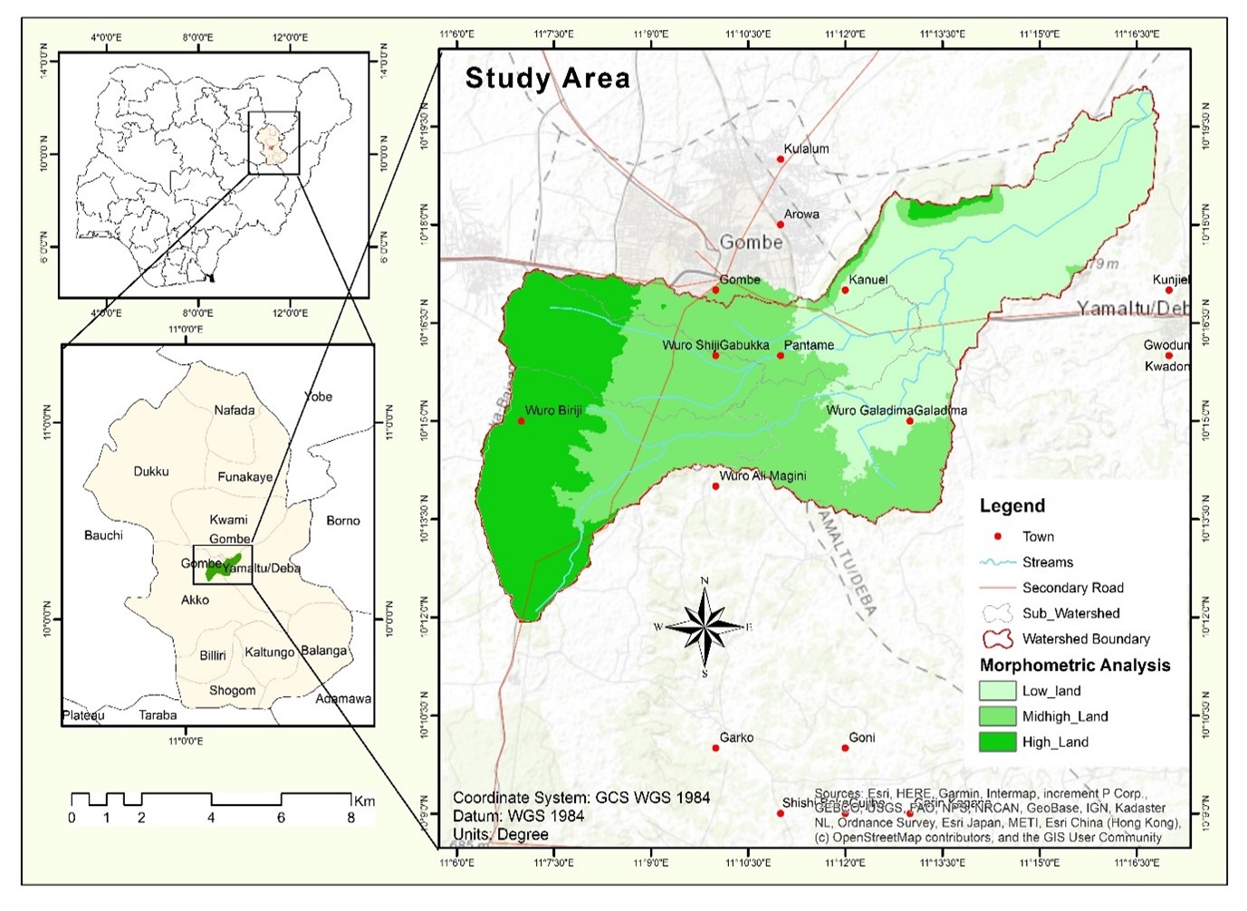
Figure 1: River Magarya Drainage Basin
Source; ArcGIS 2023
MATERIAL AND METHOD
In assessing land use and land cover in Magarya watershed, Sentinel 2A, Landsat 7 TM, and Landsat 8 TIR/OLI satellite images were employed. To minimize variability related to image-taking periods, all images used were captured between June and August each year. Pre-processing, including radiometric and geometric corrections, was crucial in transforming the image data into an interpretable format (Vicente-Serrano, et al, 2008). Landsat 7 TM and 8 OLI/TIR, with a Worldwide Reference System (WRS) row and path of 173 and 062, respectively, were utilized. Geo-referencing and transformation enabled interpretation of earth surface attributes. Following image preparation, layer stacking grouped bands together, enhanced spectral information. Image enhancement improved overall interpretability before conducting image classification.
Considering the cloud cover around the watershed in June and August, the study focused on four years for land use and land cover (LULC) evaluation: 1992, 2002, 2012, and 2022. Five classes were considered: “Bare Land, Buildup, Farmland, Vegetation, and Gullies”. Post-classification analysis, incorporating the confusion matrix, overall accuracy, and Kappa index, validated the classification (Foody, 2020). Classification was deemed reliable when the Kappa index exceeded 0.70 (70%). The results, presented as a confusion matrix, were visualized through an alluvial plot to illustrate areas gained or lost for each class. Percentages of each class relative to the whole watershed area and specific class areas were also provided.
RESULTS
Results obtained from land use and land cover change, after analyzing classified images from 1992 to 2022, are presented in Figures 2 to 5 which show five LULC types and their distribution across the Magarya watershed.
Land classes of the Magarya catchment in 1992
River Magarya Basin covers an area of 85.74 km² in 1992 as shown in Table 1. Out of the total land area, the channel covered 2.22 km² of the surface area. Of the remaining area, 15.43 km² was built-up, 17.41 km² was covered by farmland, 26.85 km² was bare land, and 23.80 km² was covered by vegetation. Therefore, the total area covered by the channel as of 1992 was 2.22 km², which is 3 percent of the total area covered by the channel thirty (30) years ago (1992). Figure 2 shows the gully erosion sites in the Magarya Basin in 1992.
Table 1: Land classes of Magarya catchment in 1992
| LULC Classes | Area (km2) | Percentage (%) |
| Bare land | 26.85 | 31 |
| Built-Up | 15.43 | 18 |
| Farmland | 23.85 | 20 |
| Vegetation | 17.41 | 28 |
| Gully | 2.22 | 3 |
| Total | 85.74 | 100.00 |
Source: field survey 2023
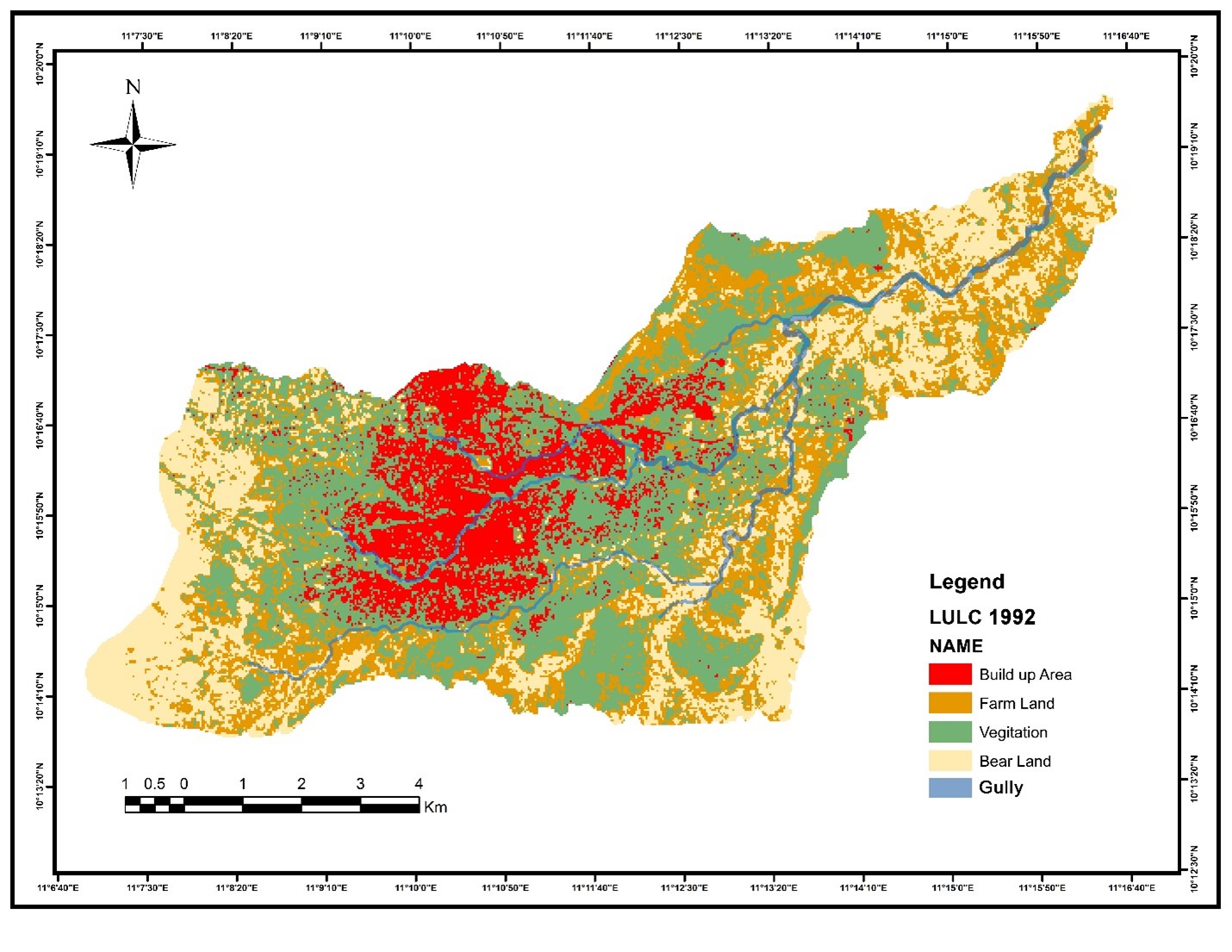
Figure 2. Land classes of Magarya catchment in 1992
Source; ArcGIS 10.3, 2023
Land classes of Magarya catchment in 2002
In 2002, River Magarya catchment covered an area of 85.74 km² as shown in Table 2. Out of the total area, the channel covered 4.22 km² of the surface area. Of the remaining area, 20.44 km² was built-up, 17.92 km² was covered by farmland, 35.86 km² was bare land, and 7.81 km² was covered by vegetation. Therefore, the total area covered by the channel as at 2002 was 4.22 km² which is 5% of the total area covered by the catchment twenty (20) years ago.
Table 2: Land classes of Magarya catchment in 2002
| LULC Classes | Area (km2) | Percentage (%) |
| Bare land | 35.86 | 42 |
| Built-Up | 20.44 | 24 |
| Farmland | 17.92 | 21 |
| Vegetation | 7.81 | 9 |
| Gully | 4.22 | 5 |
| Total | 85.74 | 100.00 |
Source: field survey 2023
Figure 3: Land classes of Magarya catchment in 2002
Source; ArcGIS 10.3, 2023.
Land classes of Magarya catchment in 2012
In 2012, the area covered by River Magarya catchment remained the same (85.74 km²) as shown in Table 3. Out of the total area, the channel covered 5.12 km² of the surface area. Of the remaining area, 23.54 km² was built-up area, 16.92 km² was covered by farmland, 33.86 km² was bare land and vegetation covered 6.81 km². Therefore, the total area covered by gullies as of 2012 was 5.12 km², which is 6% of the total area covered by catchment ten (10) years ago (2012).
Table 3: Land classes of Magarya catchment in2012
| LULC Classes | Area (km2) | Percentage (%) |
| Bare land | 33.86 | 39 |
| Built-Up | 23.54 | 27 |
| Farmland | 16.92 | 20 |
| Vegetation | 6.81 | 8 |
| Gully | 5.12 | 6 |
| Total | 85.74 | 100.00 |
Source: field survey 2023
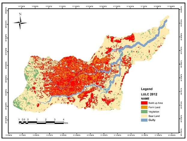
Figure 4: Land classes of Magarya catchment in 2012
Source; ArcGIS 10.3, 2023.
Land classes of Magarya catchment in 2022
The results obtained from the research reveal that the present extent of gully erosion (Table 4) covered a land area of 6.25 km², while 25.44 km² of land was built-up, 14.52 km² was farmland, 31.76 km² was bare land, and 8.81 km² was covered by vegetation. Therefore, the total land area covered by the channel in 2022 was 6.52 km², making it 6.5% of the total land area of the Magarya Basin. Figure 5 shows the gully erosion sites in the Magarya Basin in 2022.
Table 4: Land classes of Magarya catchment in2012
| LULC Classes | Area (km2) | Percentage (%) |
| Bare land | 31.76 | 37 |
| Built-Up | 25.44 | 30 |
| Farmland | 14.52 | 17 |
| Vegetation | 8.81 | 9.5 |
| Gully | 6.25 | 6.5 |
| Total | 85.74 | 100.00 |
Source: field survey 2023
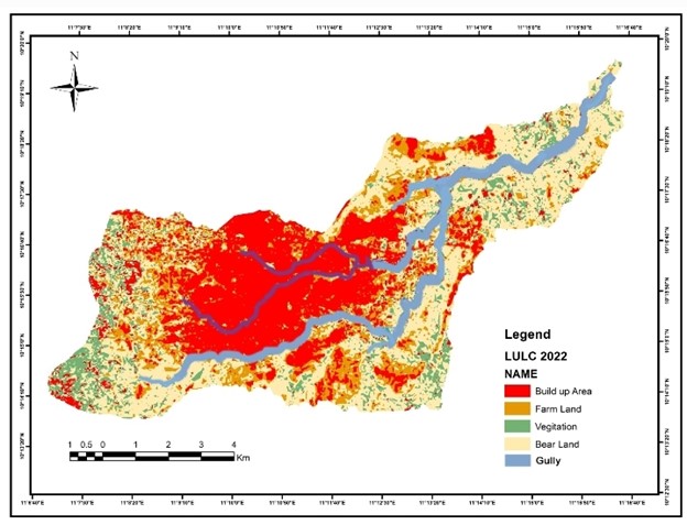
Figure 5: Land classes of Magarya catchment in 2022
Source; ArcGIS 10.3, 2023
Rate of Expansion of River Magarya channel
The rate of expansion of a river channel can vary widely depending on various factors such as geology, climate, land use, and human activities. Several studies have been conducted to understand the factors influencing channel expansion and to quantify its rate, as noted in the works of Kondolf, et al, (2003); Hooke, et al, (2007); Guo, et al, (2016); Perks, et al, (2018); Lopes, et al, (2019) and Wu, et al, (2021). It is important to consider these factors in managing river systems and mitigating their impacts on human activities and ecosystems (Lopes, et al, 2019).
Upon considering the present extent of Magarya Channel, it is evident that from 1992 to 2022 (30-year interval), erosion sites in the Magarya Channel increased from 3% in 1992 to 5% in 2002, 6% in 2012 and 6.5% in 2022, resulting in a total expansion rate of 3.5%. This percentage (3.5%) represents 3.3 km², equivalent to an average of 1.10 km² (for every 10 years or 0.11 km² every year) of land lost to erosion. The implication of this is that the expansion of the channel hampers human economic activities in the basin in several ways, including the high cost of constructing structural facilities such as roads, bridges and houses (Auwal and Wanah, 2023). The cause of the channel’s expansion due to erosion was the continued clearance of vegetation for residential and agricultural activities, exposing the soils to denudational processes, making the unconsolidated soil loose and unprotected thereby facilitating erosional activities. Additionally, impermeable surfaces in residential areas attributed to zinc-coated roofs, cemented surfaces, and tarred roads have concentrated surface runoff thereby further expanding the channel (Magilligan, et al, 2014).
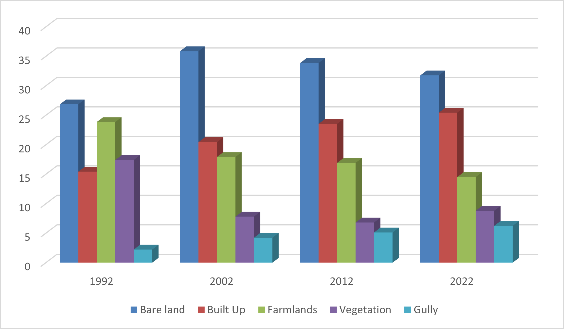
Figure 6: LULC from 1992 to 2022
Source: Authors’ Compilations 2023
DISCUSSION
Dynamic changes in terms of LULC in Magarya watershed
This study unveils dynamic changes in LULC within the Magarya watershed of Gombe Metropolis. The transformation is evident in the conversion of farmlands and vegetation cover predominantly into built-up areas, with other areas either being cleared for fuel wood or left barren (Tables 1-4 and Figures 2-5). These dynamic LULC changes are influenced by various factors, categorized as direct or indirect (Geist and Lambin, 2002) often stemming from social and economic development (Wu, 2018).
Factors such as agricultural activities, wood and Non-Timber Forest Products (NTFP) extraction, urban infrastructure, and livestock extension are primary drivers of LULC changes in Magarya watershed. Additionally, political, economic, and demographic factors, particularly socio-cultural elements, contribute to these transformations (Auwal and Wanah, 2023). Over a period of five years (2015 to 2019), there has been an extension of agricultural land, bare soil, and settlements driven by rapid population growth and projects aimed at enhancing productivity (Mutabazi, 2013). The consequences of these dynamics include long-term loss of soil fertility, increased soil erosion, reduced biological diversity, hydrological changes, and modification of local climatic conditions (Egeru, et al, 2010). Inappropriate land use, recognized as a key driver of land degradation and climate change, is exacerbated by human activities and natural processes (Frankl, et al, 2013; Mekonnen and Hoekstra, 2016).
Expansion of land under cultivation for subsistence farming is driven by population demands and policy changes in land tenure and settlement rights (Houghton, 1991). This expansion exerts pressure on watershed natural resources, coupled with poor farm management impacting soil quality and productivity in North-Eastern Nigeria (Heri-Kazi, 2020). The resulting pressure on land, lack of water retention and removal of vegetation contribute to crop failure, low productivity and food insecurity in the region. Despite dwindling productivity, insufficient action has been taken by stakeholders and decision-makers. Farmers and watershed actors’ knowledge and understanding of the issue necessitated integrated action and involvement of other stakeholders to address the problem effectively (Moges and Holden, 2007; Moges and Holden, 2009).
Urbanization and town or city development contribute to LULC changes through the expansion of settlements at the expense of farmland, woodland, and forest (Anteneh, et al, 2018). From 1992 to 2002, the rapid expansion of settlements and bare soil is associated with population displacement from villages to Gombe Metropolis following the emergence of Gombe State in 1996 (Geenen and Mutokanyi, 2013). Hence, LULC changes result from the intricate interaction of political, social, economic, and biophysical factors (Degife, et al, 2019).
Land use and land cover dynamics affects gullies expansion rate
Various studies have explored the characteristics of gullies in tropical and global contexts. Jahantigh and Pessarakli (2011) concluded that gullies develop due to a decrease in soil surface resistance to erosion or an increase in erosive forces. In Dashtyari, Iran, gully formation was attributed to human activities, overgrazing, and intense, short-term rainfall. Notably, longer gullies were observed in flat plains. Agricultural activities, compounded by deforestation and local gold mining, played a significant role in triggering gully formation, as demonstrated by the relationship between forest cover and gully extension rate.
Forests and trees, by providing protective cover to the soil and preventing soil erosion through root anchoring and raindrop impact reduction, play a crucial role in controlling gully erosion (Degife et al., 2019). The loss of forest and vegetation in the Magarya watershed, evident in deforestation, overgrazing, and over-cultivation, has compromised the soil’s structure and cohesiveness, making it more susceptible to erosion.
The efficacy of woodland and forest in mitigating gully erosion has been validated by studies (Li, 1992; Lutete, 2019). Forests reduce runoff and sediment yields, especially on flat ridges and slopes lacking control measures. Boardman et al. (2003) emphasized that land degradation, manifesting as rill and gully erosion, coincides with grassland reduction, species diversity decline, and ground cover reduction. In regions with bare soil and settlements, gullies of considerable depth and surface area can develop, resulting in varying expansion rates. Woodland and forest cover substantially reduce the expansion rate compared to other land uses.
Despite lower retreat rates, distinctions were observed between gullies in forested areas and those in other land uses. The highest erosion expansion rate occurred on bare ground and settlements. The impact of land use and land cover dynamics as drivers, along with environmental implications, was underscored in Ethiopian watersheds (Degife et al., 2019). These findings align with the situation in Magarya, where urban infrastructure expansion, high wood demand, tree use for income generation, biophysical factors (slope and accessibility), population growth pressure, and land tenure policies collectively explain the observed gully expansion.
CONCLUSION
This study delves into the investigation of land use and land cover changes in the Magarya watershed, analyzing expansion rates and the factors contributing to this expansion. Over the period from 1992 to 2022, approximately 3.03 km² of land has transformed into gullies due to erosion, averaging 1.1 km² every 10 years. The study reveals that gully stability in the watershed is influenced by factors such as human activities in proximity to the gullies, percentage and types of land cover, and contributing area. Consequently, preventive interventions should take these parameters into account. Despite some limitations, the employed methodology enhances our understanding of land use, land cover, gully characterization, and the impact of woodland and forest on gully expansion. Human activities emerge as significant contributors to gully development and overall land degradation. At the watershed scale, integrated recovery policies are imperative for restoring and preserving land and its productivity. Conservative practices can play a crucial role in preventing and mitigating gully-related issues in urban areas of Nigeria. This article serves as a foundational resource for initiating projects and land use planning, not only for the Magarya watershed but also for other areas in Gombe Metropolis sharing similar environmental conditions. The adopted methodology, which integrates various data sources to elucidate the relationship between land use, land cover changes, and gully expansion, should be expanded to encompass other watersheds across Nigeria. Site knowledge acquired through field visits and the use of Very High-Resolution (VHR) images were pivotal for digitizing and characterizing gullies at the watershed scale.
REFERENCES
- Adediji, A., Jeje, L.K., Ibitoye, M.O., 2013. Urban development and informal drainage patterns: Gully dynamics in Southwestern Nigeria. Appl. Geogr. 40, 90–102 .
- Anteneh, Y. , Stellmacher, T. , Zeleke, G. , Mekuria, W. , Gebremariam, E. , 2018. Dynamics of land change: insights from a three-level intensity analysis of the Legedadie-Dire catchments, Ethiopia. Environ. Monit. Assess. 190 (5), 309 .
- Angel, S., Parent, J., Civco, D.L., Blei, A., Potere, D., 2011. The dimensions of global urban expansion: Estimates and projections for all countries, 2000–2050. Prog. Plann. 75, 53–107.
- Auwal, A. M. & Wanah, B. B. (2023), Determination of the Drainage Density of River Riyadh Basin in Akko Local Government Area of Gombe State, Nigeria. Bima Journal of Science and Technology (2536-6041), 7(1), 230-243. https://doi.org/10.56892/bima.v7i01.402
- Auwal, A. M. & Wanah, B. B. (2023), Analysis of morphometric properties for prioritization of sub watershed for erosion control in Magarya Catchment, Gombe Metropolis, Gombe State, Nigeria, presented at Association of Nigerian Geographers first North-East Nigeria conference, Gombe State University.
- Bogaert, J., Colinet, G., Mahy, G. (Eds.), 2018. Anthropi-sation of Katangese Landscapes. Presses Universitaires de Liège – Agronomie-Gem-bloux, Gembloux, Belgique, pp. 281–296 (in French).
- Busnelli, J., Neder, L.del V., Sayago, J.M., 2006. Temporal dynamics of soil erosion and rainfall erosivity as geoindicators of land degradation in Northwestern Argentina. Quat. Int. 158 (1), 147–161 .
- Boardman, J. , Poesen, J. , Evans, R. , 2003. Socio-economic factors in soil erosion and con- servation. Environ. Sci. Policy 6 (1), 1–6 .
- Czuba, J. A., &Foufoula-Georgiou, E. (2014). Historical channel dynamics and sediment transport in the Minnesota River Basin, USA. Geomorphology, 204, 661-674.
- De Geeter, S., Verstraeten, G., Poesen, J., Campforts, B., Vanmaercke, M., 2023. A data driven gully head susceptibility map of Africa at 30 m resolution. Environ. Res. 224, 115573
- De Oliveira, C.M.M. , Francelino, M.R. , de Mendonça, B.A.F. , Ramos, I.Q. , 2020. Obtaining morphometric variables from gullies using two methods of interpolation laser scanner data: the case study of Vassouras, Brazil. J. Mountain Sci. 17 (12), 3012–3023 .
- Degife, A. , Worku, H. , Gizaw, S. , Legesse, A. , 2019. Land use land cover dynamics, its drivers and environmental implications in Lake Hawassa Watershed of Ethiopia. Re- mote Sens. Appl.: Soc. Environ. 14, 178–190.
- Egeru, A. , Okello, P. , Majaliwa, M.G.J. , Mukwaya, P. , Isubikalu, P. , 2010. The effect of land use/cover change on biomass Stock in dryland areas of Eastern Uganda. A case study of Olio Sub-county in Soroti District. J. Appl. Sci. Environ. Manag. 14 (4) .
- Foody, G.M., 2020. Explaining the unsuitability of the kappa coefficient in the assessment and comparison of the accuracy of thematic maps obtained by image classification. Remote Sens. Environ. 239, 111630. doi: 10.1016/j.rse.2019.111630 .
- Galang, M.A. , Markewitz, D. , Morris, L.A. , Bussell, P. , 2007. Land use change and gully erosion in the Piedmont region of South Carolina. J. Soil Water Conserv. 62 (3), 122–129 .
- Guo, H., Li, X., Zhang, J., & Yang, W. (2016). Estimation of river channel area using multi-source remote sensing data. Remote Sensing, 8(5), 398.
- Geist, H.J. , Lambin, E.F. , 2002. Proximate causes and underlying driving forces of tropical deforestationtropical forests are disappearing as the result of many pressures, both local and regional, acting in various combinations in different geographical locations. Bioscience 52 (2), 143–150 .
- Hooke, J. M., Gellis, A. C., & Jacobson, R. B. (2007). Rates and processes of river channel widening in the lower River Avon, England, 1638-2000. Geomorphology, 91(1-2), 81-101.
- Hu, G. , Wu, Y. , Liu, B. , Zhang, Y. , You, Z. , Yu, Z. , 2009. The characteristics of gully erosion over rolling hilly black soil areas of Northeast China. J. Geog. Sci. 19 (3), 309–320 .
- Houghton, R.A. , 1991. Tropical deforestation and atmospheric carbon dioxide. In: Tropical Forests and Climate. Springer, Dordrecht, pp. 99–118 .
- Heri-Kazi, B.A. , 2020. Caractérisation de l’état de dégradation des terres par l’érosion hydrique dans le Sud-Kivu montagneux àl’Est de la RD Congo. Doctoral dissertation, UCL-UniversitéCatholique de Louvain .
- Ilombe, M.G., Landu, E.L., Imwangana, F.M., Nzolang, C., Nandefo, W., Poesen, J., Bield-ers, C., Dewitte, O., Vanmaercke, M., 2021. Quantifying the impacts of urban gullying at the scale of the Democratic Republic of Congo. In: EGU General Assembly 2021, pp. EGU21–E8831. doi: 10.5194/egusphere-egu21-8831
- Jahantigh, M., Pessarakli, M., 2011. Causes and effects of gully erosion on agricul- tural lands and the environment. Commun. Soil Sci. PlantAnal. 42 (18), 2250–2255. doi: 10.1080/00103624.2011.602456 .
- Jahantigh, M., Pessarakli, M., 2011. Causes and effects of gully erosion on agricul- tural lands and the environment. Commun. Soil Sci. PlantAnal. 42 (18), 2250–2255. doi: 10.1080/00103624.2011.602456 .
- Junior, O.C., Guimaraes, R., Freitas, L., Gomes-Loebmann, D., Gomes, R.A., Martins, E., Montgomery, D.R., 2010. Urbanization impacts upon catchment hydrology and gully development using mutli-temporal digital elevation data analysis. Earth Surf. Process. Landforms 35 (5), 611–617
- Kayembe, W.K.M., Wolff, E., 2015. Contribution of the geographical approach to the study of the human factors of intra-urban gully erosion in Kinshasa (D.R. Congo). Geo-E-co-Trop 39 (1), 119–138 (in French)
- Karolien, V., Anton, V.R., Maarten, L., Eria, S., Paul, M., 2012. Landscape and urban plan-ning urban growth of Kampala, Uganda : Pattern analysis and scenario development. Lands. Urban Plan. 106 (2), 199–206 .
- Kondolf, G. M., Boulton, A. J., O’Daniel, S., Poole, G. C., Rahel, F. J., Stanley, E. H., … & Wilcox, A. C. (2003). Process-based ecological river restoration: visualizing three-dimensional connectivity and dynamic vectors to recover lost linkages. Ecology and Society, 8(2), 5.
- Lesschen, J.P. , Kok, K. , Verburg, P.H. , Cammeraat, L.H. , 2007. Identification of vulnerable areas for gully erosion under different scenarios of land abandonment in Southeast Spain. Catena 71 (1), 110–121 .
- Lopes, A., Leite, F., Rossetti, D., & Costa, M. (2019). The geomorphological signature of the world’s largest river: spatial and temporal changes in the Amazon River channel area. Earth Surface Processes and Landforms, 44(7), 1478-1490.
- Li, Z. , 1992. The effects of forest in controlling gully erosion. In: Erosion, Debris Flows and Environment in Mountain Regions (Proceedings of the Chengdu Symposium, July 1992), 1992. IAHS Publication no. 209 .
- Lutete, L.E. , 2019. Comprendre l’efficacitédes mesures de stabilisation des ravines àKin- shasa Master thesis . University of Liege, Belgium .
- Mbaya L. A., Haruna K. A., & John A. An Assessment of Gully Erosion in Gombe Town, Gombe State, Nigeria. Journal of Geography and Geology 4(3) DOI:10.5539/jgg4n3110
- Morgan, RPC. , Mngomezulu, D. , 2003. Threshold conditions for initiation of valley-side gullies in the Middle Veld of Swaziland. Catena 50 (2-4), 401–414 .
- Menéndez-Duarte, R., Marquínez, J., Fernández-Menéndez, S., Santos, R., 2007. Incised channels and gully erosion in Northern Iberian Peninsula: Controls and geomorphic setting. Catena 71 (2), 267–278 .
- Mekonnen, M.M. , Hoekstra, A.Y. , 2016. Four billion people facing severe water scarcity. Sci. Adv. 2 (2), 1500323 pe .
- Moges, A. , Holden, N.M. , 2007. Farmers’ perceptions of soil erosion and soil fertility loss in Southern Ethiopia. Land Degrad. Devel. 18 (5), 543–554 .
- Mutabazi, V.B., 2013. Effects of Mining Activities on Kibali River Water Quality Before the Implementation of Kibali Gold Mine. Makerere university Thesis Doctoral disser- tationavailable at http://hdl.handle.net/10570/2860 .
- Moeyersons, J., Byizigiro, V., Vandecasteele, I., Nkurunziza, D., Sahani, W., Nahimana, L., Lutumba, I., Trefois, P., 2015. Nature and extent of catastrophic erosion in the Kivu re-gion, Congo (DRC). In: Roose, E. (Ed.), Restoring Productivity of Tropical and Mediter-ranean Soils. Contribution to Agroecology. IRD, Montpellier, pp. 34–45 (in French) .
- Magilligan, F. J., Nislow, K. H., Kynard, B., Hackman, A., & Snyder, N. P. (2014). Long-term changes in the channel and floodplain of the Connecticut River in Massachusetts and New Hampshire, USA. Earth Surface Processes and Landforms, 39(14), 1862-1876.
- Nyssen, J. , Poesen, J. , Veyret-Picot, M. , Moeyersons, J. , Haile, M. , Deckers, J. , …Gov- ers, G. , 2006. Assessment of gully erosion rates through interviews and measurements: a case study from northern Ethiopia. Earth Surf. Processes Landforms 31 (2), 167–185
- Perks, M. T., Large, A. R. G., Reaney, S. M., & William, J. (2018). Channel change rates in gravel bed rivers: A review of UK data. Earth Surface Processes and Landforms, 43(8), 1577-1592.
- Rodrigues, M.V.C., Guimarães, D.V., Galvão, R.B., Patrick, E., Fernandes, F., 2022. Ur-ban watershed management prioritization using the rapid impact assessment matrix (RIAM-UWMAP), GIS and field survey. Environ. Impact Assess. Rev. 94, 106759 .
- Rodrigues, M.V.C., Guimarães, D.V., Galvão, R.B., Patrick, E., Fernandes, F., 2022. Ur-ban watershed management prioritization using the rapid impact assessment matrix (RIAM-UWMAP), GIS and field survey. Environ. Impact Assess. Rev. 94, 106759 .
- Rahmati, O., Kalantari, Z., Ferreira, C.S., Chen, W., Soleimanpour, S.M., Kapovi ć-Solomun, M., Seifollahi-Aghmiuni, S., Ghajarnia, N., Kazemi Kazemabady, N., 2022. Contribution of physical and anthropogenic factors to gully erosion initiation. Catena 210, 105925 .
- Sikuzani, Y.U., André, M., Mahy, G., Kaleba, S.C., Malaisse, F., Kankumbi, F.M., Bo-gaert, J., 2018. Landscape interpretation of the urbanization process in Lubumbashi (DR Congo): Dynamics of the spatial pattern and monitoring of ecological indicators between 2002 and 2008. In:
- Sow, S.A., 2020. Dynamic geomorphology: Systemic analysis of continental water mor-phodynamics by gully. Eur. Sci. J. 16 (15), 78–98 (in French) .
- Smith, L. C., Feng, M., Gao, H., Li, M., Savenije, H. H., & van der Ent, R. J. (2020). Channel change on the Mekong River: History, impacts and implications for livelihoods and food security. Progress in Physical Geography: Earth and Environment, 44(2), 155-178.
- Tumwesigye, S., Vanmaercke, M., Hemerijckx, L.M., Opio, A., Poesen, J., Twongyirwe, R., Van Rompaey, A., 2021. Spatial patterns of urbanisation in Sub-Saharan Africa: A case study of Uganda. Dev. South. Afr. 40, 1–21 .
- Valentin, C., Poesen, J., Li, Y., 2005. Gully erosion: Impacts, factors and control. Catena 63, 132–153.
- Wu, Y., Zhang, X., Guo, Y., & Liu, J. (2021). Estimating channel morphology and sediment flux in the Mississippi River using a hydraulic model. Geomorphology, 377, 107626.