
Farmers Weather Knowledge in Preparations for Rain-Fed Crop Cultivation in Fundong Subdivision Northwest Region, Cameroon
- Chia Peter Ta-ah
- Nkwemoh Clement Anguh
- Elvis Nsopkwi
- 816-827
- Dec 8, 2023
- Geography
Farmers Weather Knowledge in Preparations for Rain-Fed Crop Cultivation in Fundong Subdivision Northwest Region, Cameroon
Chia Peter Ta-ah1*, Nkwemoh Clement Anguh1 & Elvis Nsopkwi2
1Department of Geography, Faculty Arts, Letters and Social Sciences, University of Yaounde 1, Cameroon
2Department of Geography & Planning, Faculty of Arts, University of Bamenda, Cameroon
*Corresponding Author
DOI: https://dx.doi.org/10.47772/IJRISS.2023.7011063
Received: 28 October 2023; Revised: 07 November 2023; Accepted: 18 November 2023; Published: 08 December 2023
ABSTRACT
Rain-fed food crops cultivation constitutes a foremost livelihood source for humans. In Fundong subdivision, the seed sowing of rain-fed food crops is always done at the month of March following the first rains. Over the last decade, increasing uncertainty of the first rains during the planting seasons has increased tremendously and farmers have resort to the use of local sources and strategies of weather forecast to plan for seed sowing of rain-fed food crops. From these grounds, this paper seeks to investigate the strategies as well as the motives for indigenous preference in weather forecast as an adaptation strategy against the increasing uncertainties in the first rains during the planting seasons in Fundong subdivision. Data was collected from randomly selected 187 households using semi-structured questionnaires, focus groups discussions, interviews and field observations. The data collected was descriptively analysis and the results presented in the form of tables and bar charts. Photos were equally taken to portray the field reality. About seven (7) strategies viz; flowering of coffee, mist covering mountains, excessive heat during the night, smell of toilet, dew fall on leaves of bananas, trees and roof of houses observed in the morning, concentration of dark clouds in the sky and smell of rain are the strategies farmers used to forecast the onset of rains which help them prepare for the planting of rain-fed food crops. The motives for indigenous weather preference was assessed to be due to limited conventional sources of weather information, low level of education of farmers, lack of electricity in some areas of the study site, complexity of scientific weather knowledge, no weather scientist and difficult access to network in certain locations of the study area. The study opined that conventional sources of weather information should be installed in the study area in order to complement indigenous knowledge in studying extreme weather events.
Keywords: Farmers Knowledge, weather forecasting, rain-feed crop cultivation, Fundong Subdivision
INTRODUCTION
Climate variability and change have direct effects on rain-fed crops production which mankind depend on for livelihoods especially in climate-prone areas [1]. In less developing countries where majority of the population depend on agriculture for livelihood, food security is at risk, more especially, where agricultural production is mostly rain-fed [2]. Even though this climate variability and change have been occurring for over millennia, local farmers have been adapting to this changes using their local knowledge systems [3]. This is particularly in climate-prone communities which farmers have developed a good understanding and knowledge of climate variability and change adaptation and mitigation strategies [1-4]. This local knowledge systems are associated with knowledge and knowhow accumulated across generations [5-6]. The knowledge is generated through practical experience with the natural experience, locally based and transmitted orally, through demonstrations [7].
In the Africa continent, the Sub-Saharan is considered highly vulnerable to the effects of climate change probably because of its high dependence on rain-fed crop cultivation [8-9]. This vulnerability is also attributed to the fact that current climate is already severe, climate information is limited and technological advance is less evolved in Sub-Sahara Africa [10]. The impacts of climate change on agriculture could severely worsen livelihood conditions of the rural poor and increase food insecurity in the region [11].
Cameroon being one of the countries in the Africa continent is also suffering from climate variability related issues, more especially in the domain of agriculture which is the backbone of most communities. The effectiveness of conventional seasonal forecasts as a supportive decision-making tool for small scale rural farmers remains open to debate. This is because of the fact that scientific forecasts are still not easily available to agricultural population in most local areas [2]. These challenges are a course for concern for researchers to respond to the expected needs of agricultural population, relating to forecasts, with scientific tools, Indigenous forecasts or a combination of the two approaches [12].
In the North West region Cameroon, especially in Fundong Subdivision, indigenous climate variability perception is based on the observations of environmental objects, animals and plants behaviours which enable agricultural population to plan and cope with vagaries in the climatic elements that affect rain-fed crops production. This erratic climate perception is very effective in rural areas where there is difficult access to conventional sources of climate information. According to [13], mitigating the impact of climate variability and change on rain-fed crops production and livelihoods can be achieved through the use of both the available Indigenous weather knowledge systems-IWKS and conventional weather knowledge to anticipate and manage the effects of climate risks. Based on this lane, this paper focuses on farmers’ weather knowledge and preparations for rain-feed crops cultivation in Fundong subdivision in Boyo Division northwest region, Cameroon.
1.2. The study area and methods
1.2.1. The study area: Fundong subdivision is found in Fundong sub division in Boyo Division of the North West region. It is located within the grassland savannah area of the mountainous western highland region of Cameroon. It is situated about 68km from Bamenda. Fundong sub Division is found between latitude 6o4’ and 6o20’ north of the equator and between longitude 10o11’ and 10o30’ East of the Greenwich meridian. It is bounded by Wum subdivisions to the west and to the east by Noni subdivisions while to the north it is bounded by Fungom subdivision and to the south by Njinikom subdivision.
Figure 1: Location of Fundong subdivision in Boyo Division northwest region of Cameroon
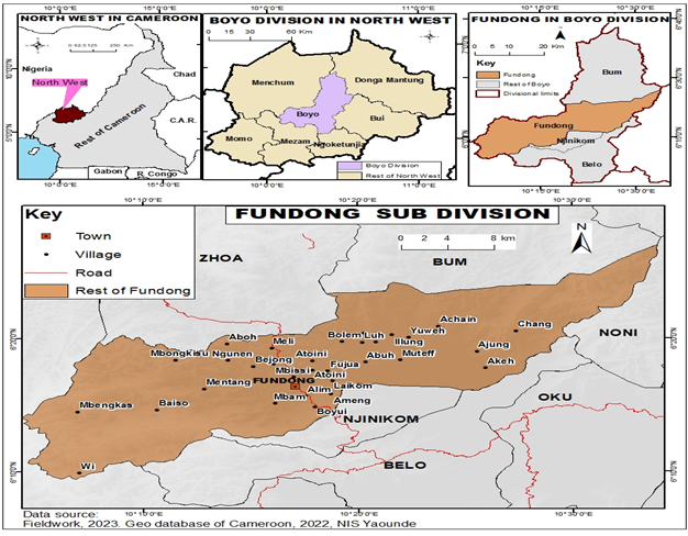
Found among the four (4) subdivisions of the Boyo Division, Fundong subdivision is made up 34 villages and numerous quarters.
With regards to climate, Fundong subdivision experiences two main seasons. These include the dry season which spans from mid-October to mid-March and a rainy season (wet) from mid-March to mid-October. The annual average rainfall stands at 2400mm per annum. These seasons have become unpredictable in the area, more especially, with vagaries in the climatic elements due to the effects of global warming.
As concerns the vegetation, Fundong subdivision is characterized with re-growth savannah, grasslands, and gallery forests, natural and domesticated woodland vegetation’s. Both natural and re-growth savannah vegetation’s spread around Mentang, Mbam Abeikang, Baiso, Mbongkisu, Laikom, Mbenkas villages. The grassland vegetation used mostly for animal grazing spread over the plains of Baijong, Mbam, and the highlands of Ngwah, Abuh, Muteff, Ibolem, Aduck and Achangne. The gallery forests spread along watercourses such as Nkoini, Jviaffief, Jvia Ngwah and Jvia Ibolem. Most watercourses within villages’ fringe are planted with raffia palm, which is an intrinsic economic plant for the indigenes of the area. The built-up areas within the urban and villages are inter-planted with fruits (mangoes, pears, guava, kola nut and plume), cypress and eucalyptus trees.
The soils are dominantly volcanic with laterites, sands and loams in depressions. In most low lying areas, soils are thick, humus and rich e.g. sedimentary warm humus rich/fertile soils which favours the cultivation of rain-fed crops like beans, maize, cocoyam, soya beans, Irish and sweat potatoes, cassava and vegetables. Generally, the dominant soil types within Fundong subdivision are lateritic and ferralitics soils.
According to the Council Development Plant-CDP (2012), Fundong subdivision is drained with rivers, streams and springs. The major rivers found within the area are: Nkoini which serves as the natural boundary between Fundong and Njinikom subdivisions; the Jviaffief, which flows from Ijim forest crossing through Fujua to Fundong Town and down to Menchum in the west; Jvia Ngwa which runs from Ijim via Muteff, Abuh, Ngwa and Meli and it also separates the Fundong subdivision and ZOA Council; Jvia Ngunabum which flows from Ijim passing through Ilung and Ngunabum and joins River Kimbi. Other streams of significant value are Jvia Ibolem, Jvia Mboh which both flow from Ijim Forest and into Jvia Ngwa. Also found are prominent springs and waterfalls like “Tchimni” in Fundong Centre and the Laikom, Akeh and Ajung waterfalls.
In respect to relief, Fundong subdivision is found in the mountainous stretch of the western highlands of Cameroon. The subdivision is characterized by topographical features such as grazing plains, steep and gentle highland areas, undulating hills and deep dry and wet valleys. The highland areas are highly used for grazing as well as features for weather forecast. The plains and deep fertile valleys are used as cultivable lands.
Considering the human background, the total population of Fundong is estimated at 45831 inhabitants (20531 males and 25300 females) covering a surface area of 519 km2 [14]. The population density is estimated at 72 to 79/km2. In Council Development Plan-CDP (2012), this population was projected at 124841 inhabitants. With regards to ethnicity, the area constitute about nine (9) different ethnic groups. These include Kom, Hausa, Mbororo, Fulani, Banso, Bayangi, Bali, Ngie and Bum. Among these ethnic groups, the Kom people constitute the highest number. The Muslim community is made up of mostly cattle rearers settled within the subdivision because of the availability of grazing lands. The main economic activities of the area constitute agriculture and commerce.
1.2.2. Materials and Methods: To realised this study, a twofold sampling technique was applied which involve; simple random and purposive sampling techniques. The simple random sampling was used to select the study population while purposive sampling was applied to select the resource persons for the study. A combination of data collected from primary and secondary sources was used for the realisation of the study. The data from primary sources was obtained from 187 randomly selected households chosen from a base population of 45831 inhabitants [14], around the target sites in the study area. This was perfected with data collected from secondary sources like the Municipal council and the Ministry of Agriculture and Rural Development (MINADER) as well as from article journals downloaded from online search through navigation tools like Google search, Google chrome, Google scholar and Opera mini. Field surveys were conducted to appraise the sources of indigenous weather knowledge and techniques of local weather forecast which help them prepare for the planting of rain-fed food crops which they depend on for livelihood. Focus group discussions were carried out with the agricultural population to obtain an accurate understanding of the types rain-fed food crop cultivated, sources and techniques used to forecast weather changes in the study area. The members selected were 30 years and above who are the indigenes of the targeted sites who have lived there for 30 years more. The exercise was participatory aimed to give all participants a chance to deeply express their opinions about the indigenous strategies of weather forecast. Direct field observations was carried out to explore the landmarks used by the agricultural population as instruments for weather forecast. The study preferred content analysis technique to carry out the analysis without eliminating the views expressed through individual interviews and focus group discussions. Descriptive analysis was employed to present the opinions of the studied population in the form of tables, pie and bar charts. Cartographic work to carve out the study area was realized with the help of Quantum Geographical Information System (QGIS).
RESULT AND DISCUSSION
2.1. Typology of rain-feed food crops cultivated in the study area
The variety of rain-fed food crops cultivated by rural farmers in the study area are varied and many (table 1).
Table 1: Different types of rain-fed crops cultivated in the study area
| Category | English Names | Scientific Names | Indigenous appellation |
|
Food Crops |
Cassava | Manih esculenta | Casala |
| Coco yams | Xanthosoma sp | Ƚlang | |
| Groundnuts | Arachis hypogaea | Boleng | |
| Maize | Zea mays | Asang | |
| White yam | Dioscorea alata | Alanghe fefea | |
| Beans | Phaseolus lunatus | Akuen | |
| Sweet Potatoes | Solanum tuberosum | Dongsɨ tufnesɨ | |
| Irish potatoes | Dongsɨ kwang | ||
| Guinea corn | Sorghum bicolor | Asang abola | |
| Soya beans | Glycine max | – | |
| Pumpkin | Cucurbita maxima | ɨboh | |
| Vegetables | Okro | Ablmoschus esculentus | Akola |
Source: Field survey, April 2023
According to field discussions, this variety of food crops in the study area are cultivated only during the rainy season.
2.2. Indigenous weather forecast and preparations for planting during the onset of the rainy season
2.2.1. Sources of weather knowledge in Fundong subdivision: A large number of agricultural population (79.5%) in the study area depend on local sources of weather knowledge (figure 2).
Figure 2: Sources of weather information
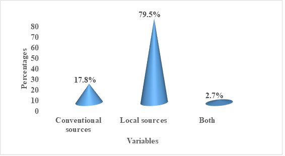
Source: Field survey, April 2023
Only a small proportion of farmers (17.8%) in Fundong subdivision uses conventional sources of weather knowledge. The high dependency of the population on indigenous sources of weather knowledge in the study area was assessed and the results presented in figure 3.
Figure 3: Motives for indigenous weather preference in Fundong subdivision
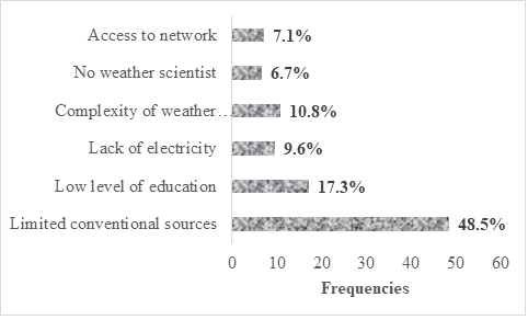
Source: Field survey, April 2023
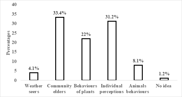
As can be seen in figure 3, field results show that limited access to conventional sources (48.5%) of weather knowledge is the main driver of population preference of indigenous weather knowledge in the study area. These include the absence of weather scientist (6.7%) who can teach them with weather changes for agricultural planning and meteorological stations were information on weather changes can be obtained. The situation is further made worse by the difficult access to network (7.1%) (MTN and orange) in some locations of the study area which can help the agricultural population get access to weather information through online search with the use of android phones. Majority of farmers in rural areas were observed using mainly simple phones that can be charged with a small solar panel. The use of Android phones in these areas was found limited due to the absence or poor network connection. Couple with the absence of electricity (9.6%) in most rural areas, difficult access to radio and TV television programs were found also to be a driving force of high dependency of farmers on local sources of weather knowledge. These include rural areas in the study area like Ngwah, Abuh, Bolem, Mbenkas; Mbongkisu, Aduk, Baiso, Mentang, Muteff, Ebosung and Ntehgum. This is similar to the study finding of [3] who found that majority of farmers in Bui division depend on local sources of weather knowledge in planning for agricultural activities due to the difficult access to electricity which makes it difficult to access weather information through the use of radio and TV televisions. It was further realised that the dominance of indigenous sources of weather activities is because of the low level of education of some farmers (17.3%) which makes it difficult for them to interpret the existing weather information. From this grounds, majority of the population used local sources to study weather changes during the onset of the rainy season which help them prepare their planting seeds pending rains in proper. These local sources include weather seers, community elders, behaviour of plants, individual perception, and animals’ behaviour (figure 4).
Figure 4: Indigenous sources of weather knowledge
Source: Field Survey, April 2023
From figure 4, community elders (33.4%) were identified to be the main source of weather information and was closely followed by individual perception with 31.2% of the studied population. Weather seers were identified to be least source of weather information in the study area. Village elders and local weather seers in the study areas are often seen as the main custodians of local knowledge systems. They are those who predict the status of agricultural season for farmers through the sacrifices offer to the traditional gods. Such sacrifices are performed at the beginning of the planting season, where the gods are invoked for a good agricultural season, before the start of the planting season. The sacrifices are invoked to forecast weathers issues like seasonal winds that may destroy crops, irregular rains as well as mite and pest that may attack crops. When this is done, farmers are being sensitized in public places like markets, road junctions as well as in funeral ceremonies by the Kwifon on strategies to overcome any uncalled event that may be a threat to their crops. For individual perceptions, it was assessed to be based on observing the behaviour of environmental entities to understand weather changes.
2.2.3. Local weather forecast and planning for planting during the onset of rainy season
In the study area, the major threat of climate variability on crop production is erratic rainfall. This is noticeable at the onset of the rainy season as in some years, rain comes early than expected while in orders years, it comes late. To this, farmers can no longer follow their tradition to plant and harvest rain-fed crops as before. Faced with this fluctuating rains at the onset of rainy season, farmers has resort to the used of indigenous strategies in weather forecast. In order to determine these strategies used in forecasting the onset of the rains during the wet season and the preparations of planting seeds for the first circle, the population were requested to identify the techniques used to forecast that rain will fall in hours, days or in week ahead (table 2).
Table 2: Indigenous techniques in forecasting the onset of the rains in Fundong subdivision
| Variables | Scaling (%) | ||||
| SA | A | D | SD | U | |
| Flowering of coffee | 34.8 | 26.4 | 17.6 | 9.1 | 12.0 |
| Mist covering mountains | 36.5 | 27.6 | 10.9 | 10.4 | 14.5 |
| Excessive body feels of heat during the night | 44.2 | 26.7 | 13.7 | 9.3 | 6.1 |
| Smell of toilet | 40.4 | 31.2 | 12.0 | 10.1 | 6.3 |
| Body feels of excessive heat during the night | 43.0 | 34.5 | 5.6 | 4.4 | 2.5 |
| Dew on leaves of bananas, trees and roof of houses in the morning | 42.7 | 37.2 | 7.5 | 7.6 | 5.0 |
| Concentration of dark clouds in the sky | 46.0 | 32.5 | 9.6 | 7.4 | 4.5 |
| Smell of rain | 29.5 | 28.0 | 24.9 | 12.1 | 5.5 |
| Others (Butterfly movement) | 20.9 | 22.7 | 36.0 | 8.3 | 12.1 |
Key: SA=Strongly Agree, A= Agree, D=Disagree, SD=Strongly Disagree, U= undecided
Source: Field survey, April 2023
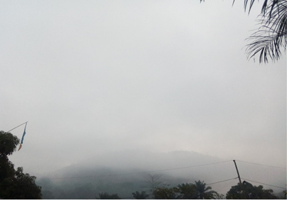
From table 2, the significant proportion of the studied population who identifies dark clouds (44.6%) and rapid increase in heat (44.2 %) can be attributed to the high concentration of the nimbus clouds in the sky during the onset of the rainy season on one hand, the rapid increase in heat can be inferred by the high concentration of the nimbus clouds that blocks heat escaping from the earth surface thus an increase in ground temperatures on the other hand. Information from the population revealed that when they observed dark clouds (plate 1) and high heat during nights especially in late February or early March, planting seeds are made ready while waiting for the rains in proper for planting to start. It was also deduced from the studied population that this observation of dark clouds and high heat in late or early March helps them to burn down heaps of grass in their farms which were not use during the preparation of land for planting.
Plate 1: Concentration of dark clouds in the sky

Source: Field Survey, April 2023
This above photo indicates one of the observable indicators of weather forecast in the study areas. Its degree of effectiveness make it one of the most used indicators to predict that there will be rain in few minutes or an hour’s time (table 3). This indicator used by farmers to predict rainfall remains functional throughout the rainy season. This is a similar scenario in Uganda and Zimbabwe as appearance of dark clouds (nimbus clouds) indicates that rain will fall in 1-3 days [15-16].
Mist-cover on mountain top is also one of the most appreciable way of predicting the onset of rains by farmers in the study area (plate 2).
Plate 2: Mist-cover on a hill
Source: Field survey, April 2023
This mist-covered (plate 2) when observed in February or early March signify the approaching of rainfall. This can be in minutes or hours depending on the nature. Table 3 presents the mist-covered highland areas used as landmarks of weather forecast in the study area.
Table 3: Distribution of mist-covered landmark indicators of weather forecast in the study
| Location | Mist-cover landmarks | Significance |
| Laikom | Akuamefeh | Rain will fall in few minutes or hours |
| Abuh/muteff | Ijim highland | |
| Ngwah Anjangum | Chuabuh Ngwah highland | |
| Yang | Yang highland | |
| Alim | Mbam highland | |
| Mbam Abeikang | Mbam highland | |
| Fundong town | Boyo highland |
Source: Field survey, April 2023
As can be seen in table 3, this indicator is very effective in areas like Laikom, Ngwah, Abuh, Ibolem and Aduke, Mbam, Alim, Yang, Fundong. This help farmers to start preparing for planting seeds and the burning of heaps of grass in farms gathered during farm preparation for the planting of rain-feed crops such like pumpkins, maize, beans, potatoes, soya beans vegetables and okra. Besides, the population also reported that when dark clouds are observed during the rainy season, that is, after the period for the onset of the rainy season, signify approaching heavy rain. This result is contrary to that of [17] as his study revealed that in South Africa, mist-covered mountains signifies good rains.
Increasing hot temperatures is also used by farmers in the study area to forecast the onset of the rains during the rainy season. This is observed through increased body feels of hot temperatures during the night. At nights, revealed by the population, places become very hot and people live without covering blankets. This indicates that rain is approaching. It was further opined that, this indicator disappears after when it rains from 1-3 days. This strategy was found to be very effective all-over the study area. In countries like Uganda, Zimbabwe, Nigeria, Kenya and Burkina Faso, this indicator is also used to forecast the onset of rains.
Dewfall observe on leaves of bananas or trees and roof of houses (plate 3) in the morning is another strategy used by the population to predict that rain may fall in hours, days or in weeks ahead. The studied population through Focus Group Discussions alluded that during the dry season, leaves of bananas, trees or any other plant that fall-off and when moving on it produces noise that can be heard at a distance, but when it is about to be rainy especially the coming of first rains in early March or late February, leaves of bananas or trees does not produced any noise when moving on it. This is because of the dew that fall on them at nights. Further discussions with the population outlines that when leaves of plants does not produced any sound when moving on during the period of the onset of the rainy seasons, this identifies that there shall be rainy in hours, days or weeks ahead. At this moment, farmers start preparing their planting seeds ahead planting.
Plate 3: Dewfall at night as an indicator of approaching rainfall
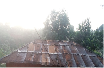
Source: Field Survey, April 2023
Dewfall, according to the population, when observe in late February or early March, signify that rain may fall in 1-7 days though at times this prediction extends more than two weeks. This indicates the appropriate time for farmers to complete unfinished work in their farms while waiting for rains in proper. It should be noted that this indigenous strategy in weather forecast became ineffective immediately after the first rains.
Apart from dewfall, it was also found that the increase smell of toilets during the onset of the rainy season signifies the approaching of rains to fall. This is because at this time the grounds are saturated with heat thus heat only leaves the ground an escaped into the atmosphere. Table 4 further clearly illustrates varied observable indicators and their significance in predicting the onset of rainy season by the population in Fundong subdivision.
Table 4: Identified indicators and significance in forecasting the onset of rainy season
| Indicators | Significance |
| Flowering of coffee | Indicates the approaching of the rainy season |
| Mist covering mountains | Rain will fall in minutes or hours’ time |
| Body feels of excessive heat during the night | Rain is at hand and farmers should prepare for planting seeds and burning of heaps of grass allow during farm preparation |
| Smell of toilet | Rains will fall in 1-3 days |
| Wet leaves of bananas, trees and roof of houses the morning due to falling dew at night | Rains are nearer and farmers should intensify farming preparations and ready farm seeds for planting |
| Concentration of dark clouds in the sky | Is about to be rainy in minutes or an hour time |
| Smell of rain/toilets | Rains are not far and farmers should prepare for their planting seeds |
| Appearance of termites | Approaching onset of rain |
Source: Field survey, April 2023
These indicators (table 4) are used by farmers in the study area to predict the onset of rain. These observed indicators helps them prepared rain-fed crops cultivation which they depend on for livelihood sustenance. Farmers indicated that these indicators are only used to determine the first rains at the beginning of the wet season which helps them plant their crops on time.
CONCLUSION AND RECOMMENDATIONS
All in all, much attentions has been given to the impacts of climate variability and change in the domain of agriculture which is the cornerstone of most local societies. Therefore, blending the local knowledge with evidence provided by formal climatology analysis, holds the potential to mitigate climate vagaries and increase the relevance of future assessments of vulnerability and climate variability and change adaptation in the domain of agriculture. In Fundong subdivision, rain-fed crop cultivation is a major source of livelihood rural population. The cultivation of the different rain fed crops is always done during the onset of the rainy season. Faced with the vagaries in climatic element (rainfall), which is one of the major environmental challenges faced during this period, majority of farmers has resorted to the use of local weather knowledge to fight against climatic risk. This high dependence of the rural population on local sources of weather knowledge is motivated by the difficult access to conventional sources of weather information, absences of weather scientist, low level of education of framers, absence or poor network connection and lack of electricity in some areas of the study area. These indigenous weather knowledge systems spans through the observation of mist-covered on highlands, simple smell of rain and toilets, dewfall, increased body feels of excessive heat, dark cloud-cover, flowering of trees and the appearance of termites. It should be noted that the effects of extreme weather events are beyond local experiences of the knowledge custodians and weather scientist. However, effective adaptation to the impacts of weather changes on rain-fed crop production requires the best knowledge, regardless of the source [18] cited in [2]. From these grounds, the study recommends for the effective integration of both the local and conventional sources and strategies in weather forecast as an adaptation strategy to the impacts of extreme weather conditions on rain-fed crop cultivation in Fundong subdivision in particular and the nation as a whole.
ACKNOWLEDGEMENTS
One could not have carried out this research alone as it is very challenging and complex and need assistance from people. To this, a special thanks go to my wife Aghaah Secunda Nyuo for her encouragement and contributions towards the realisation of this paper. I will like to thank in a special way the authors of journal articles consulted. In advance, I want to also thank the reviewers for the time and efforts to review this paper.
REFERENCES
- Kpadonou, R.A.B., Adégbola, P.Y., and Tovignan, S.D. (2012). Local Knowledge and Adaptation to Climate Change in Ouémé Valley, Benin, African Crop Science Journal, Vol. 20, Pp. 181–192.
- Mafongoya, P.L. and Ajayi, O.C. (editors), (2017). Indigenous Knowledge Systems and Climate Change Management in Africa, CTA, Wageningen, the Netherlands, 316pp.
- Tume, S.J.P., Kimengsi,J.D., and Fogwe, Z.N. (2019). Indigenous Knowledge and Farmer Perceptions of Climate and Ecological Changes in the Bamenda Highlands of Cameroon: Insights from the Bui Plateau, volume 7, 138; doi: 10.3390/cli7120138.
- Boansi, D.; Tambo, J.A.; Muller, M. Analysis of farmers’ Adaptation to Weather extremes in West African Sudan Savanna. Weather Clim. Extrem. 2017, 16, 1–13.
- Luka, M. (2018). Assessing the Role of Indigenous Knowledge Systems in Sustainable Conservation of Forest Resources in Binga District. (Master of Science Degree in Natural Resources Management and Environmental Sustainability), Bindura University of Science Education.
- Chia, P.T. and Nkwemoh, C.A. (2023). Indigenous Knowledge In Forest Resource Exploitation and Management in Manjo Subdivision Littoral Region, Cameroon, International Journal of Research and Innovation In Social Sciences (IJRISS). volume VII, issue IX, ISSSN 2454-6186 DOI10.47772/IJRISS
- Warren, D.M (1991). Using Indigenous Knowledge for Agricultural Development. World Bank Discussion Paper 127 Washington DC.
- Thornton, P.K., Jones, P.G., Owiyo, T., Kruska, R.L. and Herrero, M. (2008). Climate change poverty in Africa: Mapping hotspots of vulnerability. African Journal of Agricultural and Resource Economics 2 (1): 24–44.
- Hassan, R. and Nhemachena, C. (2008). Determinants of African farmers’ strategies for adapting to climate change: Multinomial choice analysis. African Journal of Agricultural and Resource Economics 2 (1): 83–104.
- Odero, K. (2011). The Role of Indigenous Knowledge in Responding to Climate Change: Local-global Perspectives. Panel 10: Roles of Local and Indigenous Knowledge in Addressing Climate In Proceedings of the African Adapt, Climate Change Symposium, Addis Ababa, Ethiopia.
- Baird, R. (2008). The Impact of Climate Change on Minorities and Indigenous Peoples. In Minority Rights Group International; Briefing: London, UK, p. 12.
- Armitage, D., Berkes. F., Dale, A., Kocho-Schellenberg, E. and Patton, E. (2011). ‘Co- management and the co-production of knowledge: learning to adapt in Canada’s Arctic.’ Global Environmental Change 21: 995–1004.
- Washington, R., Harrison, M., Conway, D. and Black, E. (2006). African climate change: taking the shorter route.’ Bull Am Meteorol Soc 87: 1355–1366.
- BUCREP. (2005). Répertoire Actualisé des Villages du Cameroun. Volume IV-Tome 7.
- Okonya, J.S. and Kroschel, J. (2013). ‘Indigenous knowledge of seasonal weather forecasting: a case study in six regions of Uganda.’ Agricultural Science 4 (12): 641 648
- Risiro, J.D., Mashoko, D., Tshuma, T. and Rurinda, E. (2012). ‘Weather forecasting and Indigenous knowledge systems in Chimanimani district of Manicaland, Zimbabwe.’ Journal of Emerging Trends in Educational Research and Policy Studies 3 (4): 561–566.
- Zuma-Netshiukhwi, G., Stigter, K. and Walker, S. (2013). ‘Use of traditional weather/climate Knowledge by farmers in south-western free state of South Africa: agro-meteorological learning by scientists. Atmosphere 4: 383–410.
- Huntington, H. H., S. Fox, F. Berkes, I. Krupnik, A. Whiting, M. Zacharof, G. McGlashan, and M. Brubaker. (2005). The changing Arctic: indigenous perspectives. ACIA. Arctic Climate Impact Assessment. Cambridge University Press, Cambridge, UK, chap. 3: 61–98.